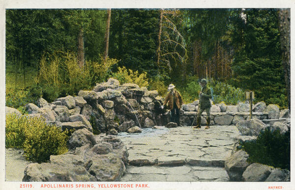
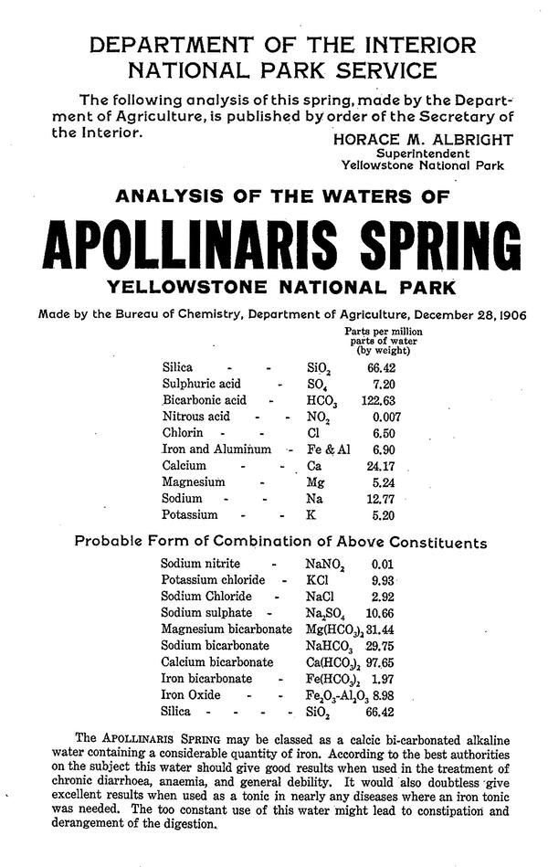
Mammoth Hot Springs at Yellowstone National Park, Wyoming.
Images
Images of Yellowstone.
Mammoth Hot Springs at Yellowstone National Park, Wyoming.
Newspaper clipping from the Billings Weekly Gazette about Leroy R. Piper's 1900 disappearance from Yellowstone National Park
Newspaper clipping from the Billings Weekly Gazette about Leroy R. Piper's 1900 disappearance from Yellowstone National ParkNewspaper clipping from the Billings Weekly Gazette, December 21, 1900, detailing possible reasons for the disappearance of Leroy R. Piper on July 30, 1900 (source: https://www.newspapers.com/clip/20351311/lr-piper-still-missing-relatives-of/).
Buffalo Soldiers with bicycles pose on Minerva Terrace, Yellowstone National Park.
Buffalo Soldiers with bicycles pose on Minerva Terrace, Yellowstone National Park.The Buffalo Soldiers of the 25th Infantry Regiment Bicycle Corps pose on Minerva Terrace, Mammoth Hot Springs, Yellowstone National Park. Pvt. John Findley, front left, was the primary bicycle mechanic for the unit, and so carried a heavy toolbox attached to his handlebars. Photo by F.
Buffalo Soldiers walk their cycles up Minerva Terrace, Yellowstone National Park
Buffalo Soldiers walk their cycles up Minerva Terrace, Yellowstone National ParkThe Buffalo Soldiers of the 25th Infantry Regiment Bicycle Corps walk their cycles up Minerva Terrace, Mammoth Hot Springs, Yellowstone National Park. Photo by F. Jay Haynes, 1896. Montana Historical Society Research Center, Haynes Foundation Photograph Collection, H-3615. Used with permission from the Montana Historical Society.
Buffalo Soldiers cycle on an inactive are of Minerva Terrace, Yellowstone National Park
Buffalo Soldiers cycle on an inactive are of Minerva Terrace, Yellowstone National ParkThe Buffalo Soldiers of the 25th Infantry Regiment Bicycle Corps ride on an inactive portion of Minerva Terrace, Mammoth Hot Springs, Yellowstone National Park. Photo by F. Jay Haynes, 1896. Montana Historical Society Research Center, Haynes Foundation Photograph Collection, H-3616. Used with permission from the Montana Historical Society.
Eruption of Excelsior Geyser, Midway Geyser Basin, in 1888
Eruption of Excelsior Geyser, Midway Geyser Basin, in 1888Eruption of Excelsior Geyser, Midway Geyser Basin, in 1888. Photograph by Frank Jay Haynes.
Eruption of Excelsior Geyser, Midway Geyser Basin, in 1888
Eruption of Excelsior Geyser, Midway Geyser Basin, in 1888Eruption of Excelsior Geyser, Midway Geyser Basin, in 1888. Photograph by Frank Jay Haynes.
Sapphire Pool in Biscuit Basin, Yellowstone National Park, in 1887
Sapphire Pool in Biscuit Basin, Yellowstone National Park, in 1887Sapphire Pool in Biscuit Basin, Yellowstone National Park, photographed by Frank Jay Haynes in about 1887. Bulbous-shaped geyserite knobs surrounding the pool reminded the photographer of biscuits. Haynes was the official Yellowstone National Park photographer at the time.
Geological map of Yellowstone National Park based on work by William Henry Holmes in 1878
Geological map of Yellowstone National Park based on work by William Henry Holmes in 1878Geological map of Yellowstone National Park based on work by William Henry Holmes in 1878 as part of Ferdinand Vandeveer Hayden’s United States Geological and Geographical Survey of the Territories, with topography mapped by Henry Gannett and triangulation by Allen David Wilson. From the Twelfth Annual Re
Hinmatóowyalahtq̓it (Chief Joseph) of the Nez Perce in 1877
Hinmatóowyalahtq̓it (Chief Joseph) of the Nez Perce in 1877Photo of Hinmatóowyalahtq̓it (Chief Joseph) taken in November 1877 by O.S. Goff in Bismarck. From Wikipedia (https://commons.wikimedia.org/wiki/File:Chief_Joseph-1877.jpg).
Hinmatóowyalahtq̓it (Chief Joseph) of the Nez Perce in 1877
Hinmatóowyalahtq̓it (Chief Joseph) of the Nez Perce in 1877Photo of Hinmatóowyalahtq̓it (Chief Joseph) taken in November 1877 by O.S. Goff in Bismarck. From Wikipedia (https://commons.wikimedia.org/wiki/File:Chief_Joseph-1877.jpg).
Painting of the Grand Canyon of the Yellowstone by artist Thomas Moran
Painting of the Grand Canyon of the Yellowstone by artist Thomas MoranPainting of the Grand Canyon of the Yellowstone by artist Thomas Moran, who was part of the Hayden Geological Survey of 1871. Painting from the Smithsonian American Art Museum.
Painting by Henry Wood Elliott (1846-1930), Yellowstone Lake, 1871
Painting by Henry Wood Elliott (1846-1930), Yellowstone Lake, 1871Painting by Henry Wood Elliott (1846-1930), Yellowstone Lake, 1871, watercolor (Phoenix Art Museum). The view is from northern Yellowstone Lake looking to the south. In the foreground, one can see the Annie in the northern lake and the three largest of the lake’s islands: Stevenson Island, with Frank Island and the smaller Dot
Illustration of Devil’s Slide, Montana, by Thomas Moran for Scriber's Monthly in 1871
Illustration of Devil’s Slide, Montana, by Thomas Moran for Scriber's Monthly in 1871Illustration of Devil’s Slide, Montana (just north of Yellowstone National Park along the Yellowstone River) by artist Thomas Moran for Scribner’s Monthly and based on a description of Nathanial Langford. The depiction is not particularly accurate, but Moran had a chance to see the feature in person when he accompanied the 1871 Hayden geological expedition to
The first photograph taken of Devil’s Slide, Montana, by William Henry Jackson
The first photograph taken of Devil’s Slide, Montana, by William Henry JacksonThe first photograph taken of Devil’s Slide, Montana (just north of Yellowstone National Park along the Yellowstone River). Photo by William Henry Jackson in either 1871 or 1873.
Henry Elliott’s 1871 map of Yellowstone Lake (https://hdylake.org/about/history-of-mapping-yellowstone-lake/). The headwaters of the Snake River, Upper Valley of the Yellowstone River, and Pelican River are shown.
Geologist Ferdinand Hayden at work with a rock hammer in 1870
Geologist Ferdinand Hayden at work with a rock hammer in 1870Geologist Ferdinand Hayden at work with a rock hammer. USGS photo by William Henry Jackson, 1870.
Geologist Ferdinand Hayden at work with a rock hammer in 1870
Geologist Ferdinand Hayden at work with a rock hammer in 1870Geologist Ferdinand Hayden at work with a rock hammer. USGS photo by William Henry Jackson, 1870.
Henry Wood Elliott during a geological expedition in 1870
Henry Wood Elliott during a geological expedition in 1870Henry Wood Elliott during a geological expedition in 1870. Photo by William Henry Jackson.
Henry Wood Elliott during a geological expedition in 1870
Henry Wood Elliott during a geological expedition in 1870Henry Wood Elliott during a geological expedition in 1870. Photo by William Henry Jackson.
Undated portrait of Jim Bridger (1804-1881). Published in Gaston's Portland, Oregon: Its History and Builders, volume 1 (1911), image in the public domain.
William Clark's 1814 map, John Colter route through Yellowstone
William Clark's 1814 map, John Colter route through YellowstoneWilliam Clark's 1814 map, indicating the route of John Colter during the winter of 1807-1808. (Library of Congress, Geography and Map Division, Washington, D.C.)
William Clark's 1814 map, John Colter route through Yellowstone
William Clark's 1814 map, John Colter route through YellowstoneWilliam Clark's 1814 map, indicating the route of John Colter during the winter of 1807-1808. (Library of Congress, Geography and Map Division, Washington, D.C.)
Yellowstone sinter research article graphic representing sample col...
Yellowstone sinter research article graphic representing sample col...Graphical abstract of the new research paper. The scientists collect samples from the rocks forming near hot springs and geysers. They dissolve small amounts of the rock in acid and organic carbon (created by living organisms) remains behind.
Time lapse of Jan 17, 2010, earthquake swarm on Madison Plateau, YNP.
Time lapse of Jan 17, 2010, earthquake swarm on Madison Plateau, YNP.Time lapse of January 17, 2010, earthquake swarm on Madison Plateau, Yellowstone National Park.
Time lapse of Jan 17, 2010, earthquake swarm on Madison Plateau, YNP.
Time lapse of Jan 17, 2010, earthquake swarm on Madison Plateau, YNP.Time lapse of January 17, 2010, earthquake swarm on Madison Plateau, Yellowstone National Park.