Moose resting in the woods outside USGS Alaska Science Center
Moose resting in the woods outside USGS Alaska Science CenterMoose is resting in the woods outside the USGS Alaska Science Center's Glenn Olds Hall.

Official websites use .gov
A .gov website belongs to an official government organization in the United States.
Secure .gov websites use HTTPS
A lock () or https:// means you’ve safely connected to the .gov website. Share sensitive information only on official, secure websites.
Browse images from a wide range of science topics covered by USGS. All items in this gallery are considered public domain unless otherwise noted.

Moose is resting in the woods outside the USGS Alaska Science Center's Glenn Olds Hall.
Moose is resting in the woods outside the USGS Alaska Science Center's Glenn Olds Hall.

Black and white images show damage caused by the 1964 earthquake and tsunami in Valdez, Alaska.
Black and white images show damage caused by the 1964 earthquake and tsunami in Valdez, Alaska.

Illustrates where Buff-breasted Sandpipers were tracked using Argos Wildlife Tracking
Illustrates where Buff-breasted Sandpipers were tracked using Argos Wildlife Tracking

Illustrates where Long-billed Curlews were tracked using Argos Wildlife Tracking.
Illustrates where Long-billed Curlews were tracked using Argos Wildlife Tracking.

Ric Wilson, a doctorate in geology and USGS research geologist at the Alaska Science Center in Anchorage, Alaska.
Ric Wilson, a doctorate in geology and USGS research geologist at the Alaska Science Center in Anchorage, Alaska.

The Alaska Forum on the Environment Forum is held each February in Anchorage, Alaska providing an opportunity for State, local, Federal, military, private, Native leaders and professionals to come together and discuss the latest projects, processes, and issues that affect Alaska.
The Alaska Forum on the Environment Forum is held each February in Anchorage, Alaska providing an opportunity for State, local, Federal, military, private, Native leaders and professionals to come together and discuss the latest projects, processes, and issues that affect Alaska.

Capelin, a small forage fish, are spawning on beaches around Alaska and your observations can contribute to our understanding of beach spawning behavior and the health of marine ecosystems.
Capelin, a small forage fish, are spawning on beaches around Alaska and your observations can contribute to our understanding of beach spawning behavior and the health of marine ecosystems.

Wolverine tracks in the snow on Crescent Lake near the Moose Pass Alaska. The wolverine is the largest terrestrial member of the family Mustelidae and is a relative of the mink and weasel.
Wolverine tracks in the snow on Crescent Lake near the Moose Pass Alaska. The wolverine is the largest terrestrial member of the family Mustelidae and is a relative of the mink and weasel.

A cross-section of an Arctic speleothem showing growth layers of calcite deposited over hundreds of thousands of years. This speleothem only grew during intervals of past permafrost thaw (i.e., interglacials), when drip water could percolate into the cave through the unfrozen epikarst.
A cross-section of an Arctic speleothem showing growth layers of calcite deposited over hundreds of thousands of years. This speleothem only grew during intervals of past permafrost thaw (i.e., interglacials), when drip water could percolate into the cave through the unfrozen epikarst.

Map of area where the USGS and USFWS may observe Pacific walrus during marine expeditions on the RV Norseman II starting in summer of 2024. Crosshatching in the map shows the general area where the Norseman II may sail to observe walruses in the summer of 2024, as part of a USGS and USFWS project to study Pacific walrus population dynamics.
Map of area where the USGS and USFWS may observe Pacific walrus during marine expeditions on the RV Norseman II starting in summer of 2024. Crosshatching in the map shows the general area where the Norseman II may sail to observe walruses in the summer of 2024, as part of a USGS and USFWS project to study Pacific walrus population dynamics.

The term “legacy data” refers to project data that are complete, or may be resurrected in the future, that were previously stored in old or obsolete formats and thus, difficult to access. These data are an important record of past ecosystem status and part of the USGS commitment to deliver actionable information relevant to decision makers.
The term “legacy data” refers to project data that are complete, or may be resurrected in the future, that were previously stored in old or obsolete formats and thus, difficult to access. These data are an important record of past ecosystem status and part of the USGS commitment to deliver actionable information relevant to decision makers.

Illustrates where Bar-tailed Godwits were tracked using Argos Wildlife Tracking.
Illustrates where Bar-tailed Godwits were tracked using Argos Wildlife Tracking.
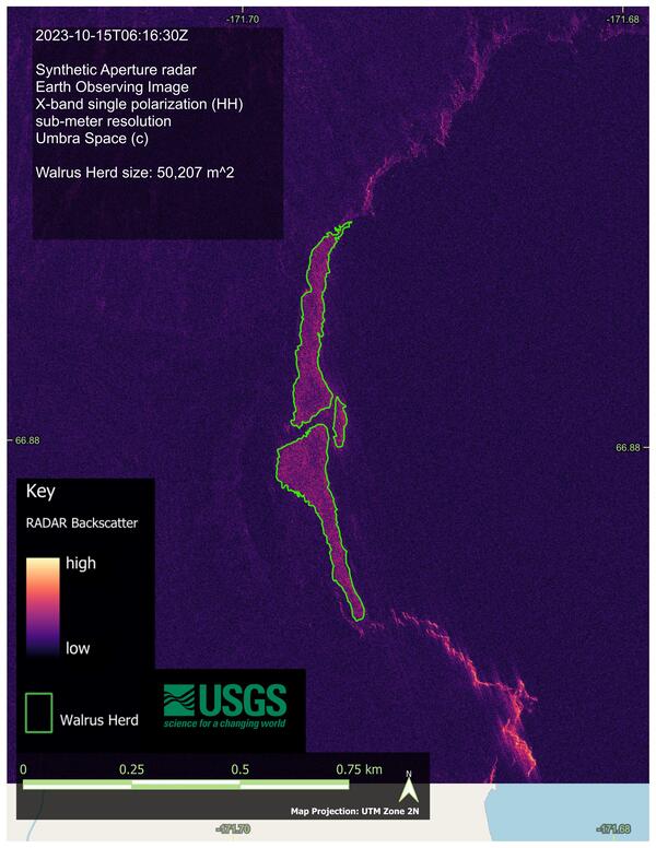
This image shows the estimated outline and area (in square meters) occupied by Pacific walrus at a large coastal haulout in Chukotka Russia in 2023 at Cape Serdtse Kamen. The image is derived from images in 2022 and 2023 from a variety of Earth observing satellite imagery sources collected at known walrus coastal haulouts in Alaska and Chukotka, Russia.
This image shows the estimated outline and area (in square meters) occupied by Pacific walrus at a large coastal haulout in Chukotka Russia in 2023 at Cape Serdtse Kamen. The image is derived from images in 2022 and 2023 from a variety of Earth observing satellite imagery sources collected at known walrus coastal haulouts in Alaska and Chukotka, Russia.

Workflow for integrating fire behavior modeling into post-fire hazard risk models. QUIC-Fire is a fast, 3-D simulation tool for prescribed fire planning. It can help managers understand the complex and dynamic behavior of wildland fires.
Workflow for integrating fire behavior modeling into post-fire hazard risk models. QUIC-Fire is a fast, 3-D simulation tool for prescribed fire planning. It can help managers understand the complex and dynamic behavior of wildland fires.

Example of a three-dimensional QUIC-Fire simulation. The example site is located in the Dixie Fire, CA. QUIC-Fire is a fast, 3-D simulation tool for prescribed fire planning. It can help managers understand the complex and dynamic behavior of wildland fires.
Example of a three-dimensional QUIC-Fire simulation. The example site is located in the Dixie Fire, CA. QUIC-Fire is a fast, 3-D simulation tool for prescribed fire planning. It can help managers understand the complex and dynamic behavior of wildland fires.

Map showing locations of placer mines in the Alaska Resource Data File (ARDF, red crosses), primary mineral districts that contain targeted critical minerals (black boxes) and locations that were sampled by the USGS in 2022 and 2023 (yellow stars).
Map showing locations of placer mines in the Alaska Resource Data File (ARDF, red crosses), primary mineral districts that contain targeted critical minerals (black boxes) and locations that were sampled by the USGS in 2022 and 2023 (yellow stars).
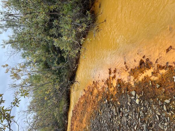
Orange streams are increasingly common in the Brooks Range of northern Alaska. The orange stream color reflects oxidized iron, but also often indicates elevated heavy metal concentrations. Our ongoing study aims to document these occurrences and the timing of their onset.
Orange streams are increasingly common in the Brooks Range of northern Alaska. The orange stream color reflects oxidized iron, but also often indicates elevated heavy metal concentrations. Our ongoing study aims to document these occurrences and the timing of their onset.

Scientist sieving a sample of gold placer tailings to analyze for critical mineral contents in Uhler Creek, a tributary to the South Fork of the Forty Mile River in east central Alaska.
Scientist sieving a sample of gold placer tailings to analyze for critical mineral contents in Uhler Creek, a tributary to the South Fork of the Forty Mile River in east central Alaska.

A fluorite-lepidolite-wolframite vein intersected in drill core from the Lost River Sn-W mine, Seward Peninsula, Alaska. Lepidolite is a lithium-bearing mica, and wolframite an ore of tungsten.
A fluorite-lepidolite-wolframite vein intersected in drill core from the Lost River Sn-W mine, Seward Peninsula, Alaska. Lepidolite is a lithium-bearing mica, and wolframite an ore of tungsten.

Research scientists overlooking Iceberg Lake in Wrangell - St Elias National Park & Preserve, Alaska.
Research scientists overlooking Iceberg Lake in Wrangell - St Elias National Park & Preserve, Alaska.

A fluorite-lepidolite-wolframite vein intersected in drill core from the Lost River Sn-W mine, Seward Peninsula, Alaska. Lepidolite is a lithium-bearing mica, and wolframite an ore of tungsten.
A fluorite-lepidolite-wolframite vein intersected in drill core from the Lost River Sn-W mine, Seward Peninsula, Alaska. Lepidolite is a lithium-bearing mica, and wolframite an ore of tungsten.