
Data collected from long distance swims by Polar bears suggest that they do not stop to rest during their journey.
Images
Browse images from a wide range of science topics covered by USGS. All items in this gallery are considered public domain unless otherwise noted.
Filter Total Items: 1612

Two Swimming Polar Bears
Data collected from long distance swims by Polar bears suggest that they do not stop to rest during their journey.

Swimming Polar Bear
Data collected from long distance swims by Polar bears suggest that they do not stop to rest during their journey.
Data collected from long distance swims by Polar bears suggest that they do not stop to rest during their journey.

An Adult Polar Bear and Her Two Cubs
An adult female polar bear and her two cubs travel across the sea ice of the Arctic Ocean north of the Alaska coast.
An adult female polar bear and her two cubs travel across the sea ice of the Arctic Ocean north of the Alaska coast.

Severely emaciated Common Murre carcass
A severely emaciated Common Murre carcass collected to determine the cause of death following a massive die-off of murres in 2015/2016. Prince William Sound
A severely emaciated Common Murre carcass collected to determine the cause of death following a massive die-off of murres in 2015/2016. Prince William Sound

Biologists walk the beach counting Common Murre carcasses
Biologists walk the beach counting Common Murre carcassesBiologists walk the beach counting Common Murre carcasses following a massive die-off of murres in 2015/2016. Prince William Sound.
Biologists walk the beach counting Common Murre carcasses
Biologists walk the beach counting Common Murre carcassesBiologists walk the beach counting Common Murre carcasses following a massive die-off of murres in 2015/2016. Prince William Sound.

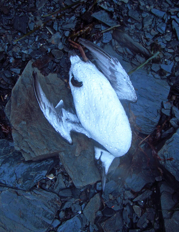
Freshly deceased Common Murre carcass
A freshly deceased Common Murre carcass recovered following the massive die-off of murres in 2015/2016. Cochrane Bay, Prince William Sound
A freshly deceased Common Murre carcass recovered following the massive die-off of murres in 2015/2016. Cochrane Bay, Prince William Sound

Freshly deceased Common Murre carcass recovered
A freshly deceased Common Murre carcass recovered following the massive die-off of murres in 2015/2016. Cochrane Bay, Prince William Sound.
A freshly deceased Common Murre carcass recovered following the massive die-off of murres in 2015/2016. Cochrane Bay, Prince William Sound.

Dead Common Murres found on the beach in Cochrane Bay, Prince William
Dead Common Murres found on the beach in Cochrane Bay, Prince WilliamDead Common Murres found on the beach in Cochrane Bay, Prince William Sound on Jan 10, 2016. These birds were part of the large die-off of Common Murres across the Gulf of Alaska in 2015-2016.
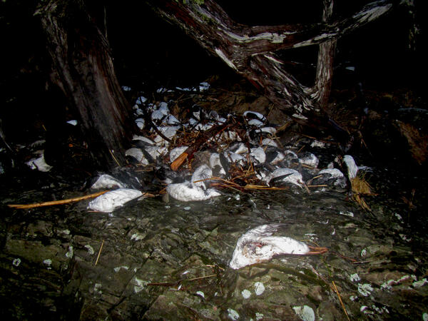
Thousands of Common Murre carcasses on beaches in Pigot Bay
Thousands of Common Murre carcasses on beaches in Pigot BayThousands of Common Murre carcasses piled up on beaches in Pigot Bay following the massive die-off of murres in 2015/2016.
Thousands of Common Murre carcasses on beaches in Pigot Bay
Thousands of Common Murre carcasses on beaches in Pigot BayThousands of Common Murre carcasses piled up on beaches in Pigot Bay following the massive die-off of murres in 2015/2016.
A dead Common Murre found on the beach in Prince William Sound
A dead Common Murre found on the beach in Prince William SoundA dead Common Murre found on the beach in Prince William Sound on Jan 7, 2016. This bird was part of the large die-off of Common Murres across the Gulf of Alaska in 2015-2016.

Drilling to take water chemistry samples for permafrost study in the Y
Drilling to take water chemistry samples for permafrost study in the YDrilling to take water chemistry samples for permafrost study in the Yukon River Basin
Drilling to take water chemistry samples for permafrost study in the Y
Drilling to take water chemistry samples for permafrost study in the YDrilling to take water chemistry samples for permafrost study in the Yukon River Basin
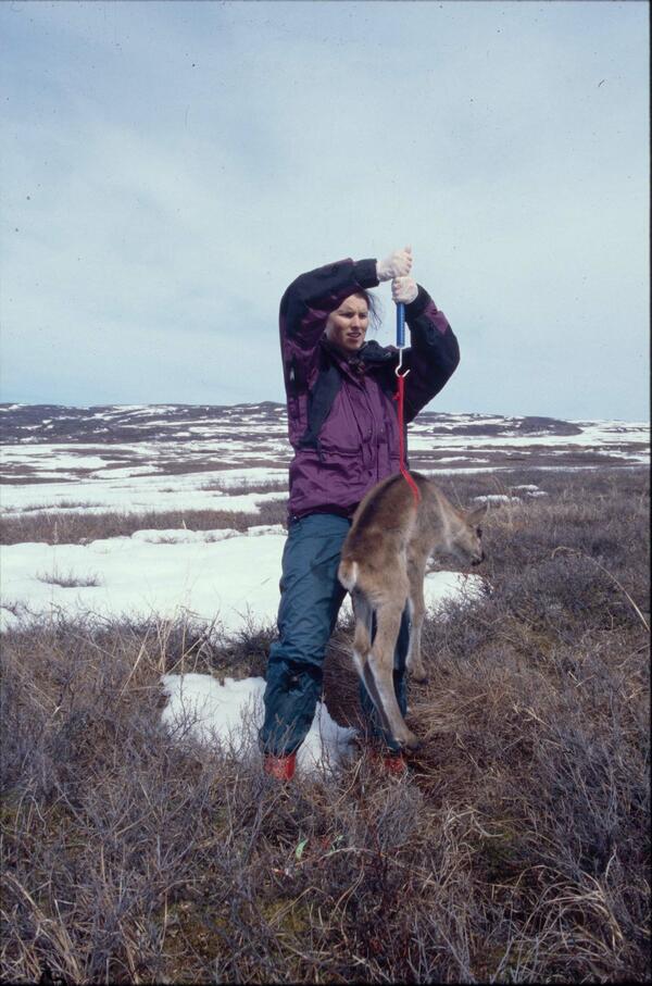
USGS biologist weighs a newborn caribou calf in Alaska
USGS biologist weighs a newborn caribou calf in AlaskaUSGS biologist Gretchen Roffler weighs a newborn caribou calf in Denali National Park, Alaska.
USGS biologist weighs a newborn caribou calf in Alaska
USGS biologist weighs a newborn caribou calf in AlaskaUSGS biologist Gretchen Roffler weighs a newborn caribou calf in Denali National Park, Alaska.

Collecting permafrost information on the Tahana River
Collecting permafrost information on the Tahana RiverDavid Pelunis-Messier and Milton Roberts navigating on the Tanana River, a main tributary of the Yukon River. The two are taking part in the Yukon River permafrost study.
Collecting permafrost information on the Tahana River
Collecting permafrost information on the Tahana RiverDavid Pelunis-Messier and Milton Roberts navigating on the Tanana River, a main tributary of the Yukon River. The two are taking part in the Yukon River permafrost study.

Researcher takes winter water chemistry samples on the Yukon River
Researcher takes winter water chemistry samples on the Yukon RiverResearcher Carol Hasburgh taking winter water chemistry samples on the Yukon River for a permafrost loss study.
Researcher takes winter water chemistry samples on the Yukon River
Researcher takes winter water chemistry samples on the Yukon RiverResearcher Carol Hasburgh taking winter water chemistry samples on the Yukon River for a permafrost loss study.

USGS scientist places radiocollar on a sedated bull caribou in Alaska
USGS scientist places radiocollar on a sedated bull caribou in AlaskaUSGS scientist Layne Adams places a radiocollar on a sedated large bull caribou in Denali National Park, Alaska.
USGS scientist places radiocollar on a sedated bull caribou in Alaska
USGS scientist places radiocollar on a sedated bull caribou in AlaskaUSGS scientist Layne Adams places a radiocollar on a sedated large bull caribou in Denali National Park, Alaska.

Permafrost Loss Dramatically Changes Yukon River Chemistry and Hydrolo
Permafrost Loss Dramatically Changes Yukon River Chemistry and HydroloYukon River freezing up at Pilot Station, AK
Permafrost Loss Dramatically Changes Yukon River Chemistry and Hydrolo
Permafrost Loss Dramatically Changes Yukon River Chemistry and HydroloYukon River freezing up at Pilot Station, AK

Whitefish drying on a fish rack in Pilot Station, AK
Whitefish drying on a fish rack in Pilot Station, AKWhitefish drying on a fish rack in Pilot Station, AK, in the Yukon River Basin.
Whitefish drying on a fish rack in Pilot Station, AK
Whitefish drying on a fish rack in Pilot Station, AKWhitefish drying on a fish rack in Pilot Station, AK, in the Yukon River Basin.

Heading out to do field work for a permafrost study in the Yukon River
Heading out to do field work for a permafrost study in the Yukon RiverHeading out to do field work for a permafrost loss study in the Yukon River Basin.
Heading out to do field work for a permafrost study in the Yukon River
Heading out to do field work for a permafrost study in the Yukon RiverHeading out to do field work for a permafrost loss study in the Yukon River Basin.

Shearing of the Melozitna Granite
Geologist and cataclastic shear zones in the Melozitna granite in the Ruby batholith. This granite contains abundant monazite and high levels of thorium and rare earth elements.
Geologist and cataclastic shear zones in the Melozitna granite in the Ruby batholith. This granite contains abundant monazite and high levels of thorium and rare earth elements.

Emperor geese at the shoreline in Kodiak
Emperor geese at the shoreline in Kodiak.
Emperor geese at the shoreline in Kodiak.
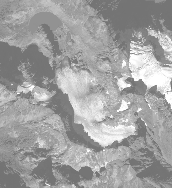
South Cascade Glacier October 14th, 2015
Aerial photograph of South Cascade Glacier, WA taken October 14th, 2015.
Aerial photograph of South Cascade Glacier, WA taken October 14th, 2015.