Fourth Avenue landslide scarp, Anchorage, Alaska. 1964.
Fourth Avenue landslide scarp, Anchorage, Alaska. 1964.Alaska Earthquake March 27, 1964.

Official websites use .gov
A .gov website belongs to an official government organization in the United States.
Secure .gov websites use HTTPS
A lock () or https:// means you’ve safely connected to the .gov website. Share sensitive information only on official, secure websites.
Browse images from a wide range of science topics covered by USGS. All items in this gallery are considered public domain unless otherwise noted.

Alaska Earthquake March 27, 1964.

A subsidence trough (or graben) formed at the head of the L Street landslide in Anchorage during the earthquake. The slide block, which is virtually unbroken ground to the left of the graben, moved to the left. The subsidence trough sank 7 to 10 feet in response to 11 feet of horizontal movement of the slide block.
A subsidence trough (or graben) formed at the head of the L Street landslide in Anchorage during the earthquake. The slide block, which is virtually unbroken ground to the left of the graben, moved to the left. The subsidence trough sank 7 to 10 feet in response to 11 feet of horizontal movement of the slide block.
Native Hospital landslide in Anchorage, showing graben and pressure ridge. The scar of an older landslide is transected by the slide of March 27.
Native Hospital landslide in Anchorage, showing graben and pressure ridge. The scar of an older landslide is transected by the slide of March 27.

Wreckage of Government Hill School in Anchorage, as viewed from the playground, looking west. The graben in the foreground is about 12 feet deep. The water tower is undamaged.
Wreckage of Government Hill School in Anchorage, as viewed from the playground, looking west. The graben in the foreground is about 12 feet deep. The water tower is undamaged.

Warehouses at the toe of the Fourth Avenue landslide in Anchorage were destroyed by compressional buckling and foreshortening that are illustrated in slides 49 and 50. Much of the supply of food and drink for the city of Anchorage was stored in these buildings, and they were guarded by Eskimo units of the Alaska National Guard.
Warehouses at the toe of the Fourth Avenue landslide in Anchorage were destroyed by compressional buckling and foreshortening that are illustrated in slides 49 and 50. Much of the supply of food and drink for the city of Anchorage was stored in these buildings, and they were guarded by Eskimo units of the Alaska National Guard.

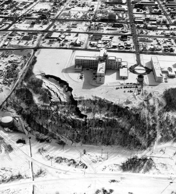
Destructive landslides and damage in Anchorage: graben at the head of the L Street landslide.
Anchorage District, Cook Inlet Region, Alaska, 1964.
Photo by A. Grantz.
Published in U. S.Geological Survey. Circular 491, Figures 18A & 18B, p.31. 1964.
Destructive landslides and damage in Anchorage: graben at the head of the L Street landslide.
Anchorage District, Cook Inlet Region, Alaska, 1964.
Photo by A. Grantz.
Published in U. S.Geological Survey. Circular 491, Figures 18A & 18B, p.31. 1964.

Alaska Earthquake March 27, 1964.
Compare the damage sustained by the Hillside Apartment Building and the adjacent three-story wood-frame dwelling with the tall chimney. In general, wood frame buildings in Anchorage sustained little damage from seismic vibration.
Alaska Earthquake March 27, 1964.
Compare the damage sustained by the Hillside Apartment Building and the adjacent three-story wood-frame dwelling with the tall chimney. In general, wood frame buildings in Anchorage sustained little damage from seismic vibration.
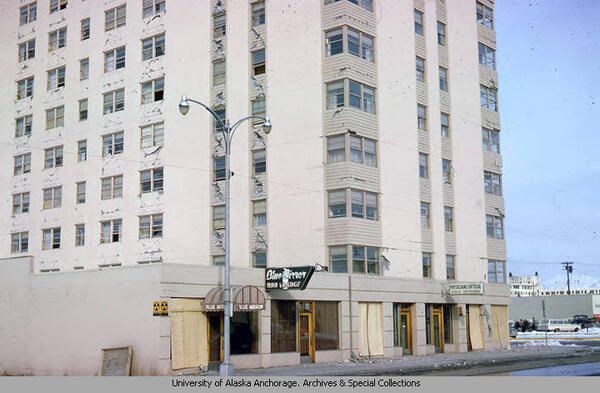
View of damage to the Mt. McKinley Apartments in Anchorage, Alaska caused by the March 27, 1964 earthquake. Image includes automobiles, people, and power lines. Yellow sign on building reads fallout shelter. Sign on building reads Blue mirror bar lounge. Sign on building, lower right, reads Physicians optical guild opticans.
View of damage to the Mt. McKinley Apartments in Anchorage, Alaska caused by the March 27, 1964 earthquake. Image includes automobiles, people, and power lines. Yellow sign on building reads fallout shelter. Sign on building reads Blue mirror bar lounge. Sign on building, lower right, reads Physicians optical guild opticans.

Low-level oblique aerial view of Fairweather fault. Photo taken east of North Dome, looking northwest, August 26, 1958.
Low-level oblique aerial view of Fairweather fault. Photo taken east of North Dome, looking northwest, August 26, 1958.
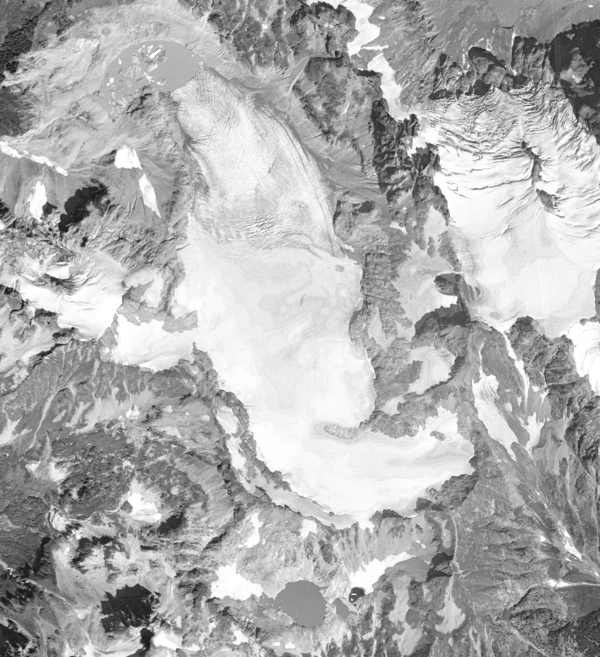
Aerial photograph of South Cascade Glacier, WA taken August 13th, 1958.
Aerial photograph of South Cascade Glacier, WA taken August 13th, 1958.

A raft of sea otters near Cohen Island in Kachemak Bay, Alaska. Sea otters rest together in groups called rafts. A raft can generally contain 10 to 100 sea otters. You will see either all male or all female with pups rafts.
A raft of sea otters near Cohen Island in Kachemak Bay, Alaska. Sea otters rest together in groups called rafts. A raft can generally contain 10 to 100 sea otters. You will see either all male or all female with pups rafts.

Emily Reynolds, a graduate student, looks through a spotting scope. The student is watching sea otters in Kachemak Bay forage. USGS researchers spend hundreds of hours annually observing sea otter foraging behavior to document prey composition and energy recovery rates.
Emily Reynolds, a graduate student, looks through a spotting scope. The student is watching sea otters in Kachemak Bay forage. USGS researchers spend hundreds of hours annually observing sea otter foraging behavior to document prey composition and energy recovery rates.

Unlike their smiling cartoon brethren on television, since 2013, real-life sea stars have been suffering from a wasting disease epidemic in which they lose limbs and literally disintegrate in a matter of days.
Unlike their smiling cartoon brethren on television, since 2013, real-life sea stars have been suffering from a wasting disease epidemic in which they lose limbs and literally disintegrate in a matter of days.

Old Chevak ancestral church reborn as research site in 1986 for 25 year cooperative banding program where Chevak youth worked with U.S. Geological Survey and U.S. Fish and Wildlife Service capturing and banding geese and swans along the Kashunuk River on Yukon-Kuskokwim Delta, Alaska.
Old Chevak ancestral church reborn as research site in 1986 for 25 year cooperative banding program where Chevak youth worked with U.S. Geological Survey and U.S. Fish and Wildlife Service capturing and banding geese and swans along the Kashunuk River on Yukon-Kuskokwim Delta, Alaska.

Eagle was our put-in point for our first synoptic cruise down the Yukon River.
Eagle was our put-in point for our first synoptic cruise down the Yukon River.

Chevak youth help funnel Cackling Geese into holding pen for banding.
Chevak youth help funnel Cackling Geese into holding pen for banding.