
View of L street looking south in downtown Anchorage, Alaska. Shows scarp from the 1964 Great Alaska Earthquake.
Images
Browse images from a wide range of science topics covered by USGS. All items in this gallery are considered public domain unless otherwise noted.
Filter Total Items: 1612

L street bend
View of L street looking south in downtown Anchorage, Alaska. Shows scarp from the 1964 Great Alaska Earthquake.

Alaska Hyperspectral Minerals Map
Preliminary map of selected minerals for a portion of the Nabesna area of interest, near Orange Hill and Bond Creek deposits in Alaska. The image, derived from HyMap imaging spectrometer data collected in July 2014, is draped on shaded relief.
Preliminary map of selected minerals for a portion of the Nabesna area of interest, near Orange Hill and Bond Creek deposits in Alaska. The image, derived from HyMap imaging spectrometer data collected in July 2014, is draped on shaded relief.

Eunbi Kwon holding a Western Sandpiper, Nome, Alaska
Eunbi Kwon holding a Western Sandpiper, Nome, AlaskaEunbi Kwon, a PhD student at Kansas State University at that time, researching the breeding ecology of shorebirds breeding at Nome as part of the Arctic Shorebird Demographics Network collaboration. The bird was marked to allow it to be individually identified when it returned to the study area.

West Twin Creek catchment with Table Top Mountain
The open black spruce forest of the West Twin Creek catchment with Table Top Mountain in the background
The open black spruce forest of the West Twin Creek catchment with Table Top Mountain in the background

Carson Baughman conducting lake survey, Kenai National Wildlife Refuge
Carson Baughman conducting lake survey, Kenai National Wildlife RefugeCarson Baughman conducting lake surveys in the Kenai National Wildlife Refuge in 2014.
Carson Baughman conducting lake survey, Kenai National Wildlife Refuge
Carson Baughman conducting lake survey, Kenai National Wildlife RefugeCarson Baughman conducting lake surveys in the Kenai National Wildlife Refuge in 2014.

Nenana River pier and sonar near Windy
Nenana River pier near Windy

Aerial image of Taku Glacier, Alaska 1948
Aerial image of Taku Glacier in 1948. The Norris Glacier can be seen on the lower left hand corner and the Hole-in-the-Wall Glacier in the upper center portion of the image. Citation: McNeil, C. J., and Baker, E. H., 2019, Geodetic data for Juneau Icefield Glaciers: orthophotos, digital elevation models, and glacier boundaries (ver 1.0, August, 2019): U.S.
Aerial image of Taku Glacier in 1948. The Norris Glacier can be seen on the lower left hand corner and the Hole-in-the-Wall Glacier in the upper center portion of the image. Citation: McNeil, C. J., and Baker, E. H., 2019, Geodetic data for Juneau Icefield Glaciers: orthophotos, digital elevation models, and glacier boundaries (ver 1.0, August, 2019): U.S.

Large polar bear being weighed by Anthony Pagano and Todd Atwood
Large polar bear being weighed by Anthony Pagano and Todd AtwoodLarge polar bear being weighed by Anthony Pagano and Todd Atwood
Large polar bear being weighed by Anthony Pagano and Todd Atwood
Large polar bear being weighed by Anthony Pagano and Todd AtwoodLarge polar bear being weighed by Anthony Pagano and Todd Atwood
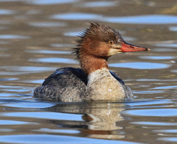
Female Common Merganser
Common Mergansers are sometimes called sawbills, fish ducks, or goosanders. The word “merganser” comes from the Latin and translates to “plunging goose”. Similar to Goldeneye ducks, mergansers usually nest in natural tree cavities.
Common Mergansers are sometimes called sawbills, fish ducks, or goosanders. The word “merganser” comes from the Latin and translates to “plunging goose”. Similar to Goldeneye ducks, mergansers usually nest in natural tree cavities.
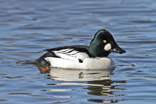
Male Common Goldeneye
The male Common Goldeneye performs a complex courtship display during winter and early spring. These diving ducks eat mostly aquatic invertebrates and fish and females nest in tree cavities.
The male Common Goldeneye performs a complex courtship display during winter and early spring. These diving ducks eat mostly aquatic invertebrates and fish and females nest in tree cavities.

Curlews perching on the predator fence in the Ki’i Unit
Curlews perching on the predator fence in the Ki’i UnitBristle-thighed Curlews perching on the predator fence in the Ki’i Unit of the James Campbell National Wildlife Refuge, Oahu, Hawaii
Curlews perching on the predator fence in the Ki’i Unit
Curlews perching on the predator fence in the Ki’i UnitBristle-thighed Curlews perching on the predator fence in the Ki’i Unit of the James Campbell National Wildlife Refuge, Oahu, Hawaii

Grazed grasses in coastal dunes at Makahoa Point on Oahu, Hawaii
Grazed grasses in coastal dunes at Makahoa Point on Oahu, HawaiiGrazed grasses interspersed with low shrubs in coastal dunes at Makahoa Point east of the James Campbell National Wildlife Refuge (JCNWR) on Oahu, Hawaii.
Grazed grasses in coastal dunes at Makahoa Point on Oahu, Hawaii
Grazed grasses in coastal dunes at Makahoa Point on Oahu, HawaiiGrazed grasses interspersed with low shrubs in coastal dunes at Makahoa Point east of the James Campbell National Wildlife Refuge (JCNWR) on Oahu, Hawaii.

Controlled fire studies provide data on archaeological sites impacts
Controlled fire studies provide data on archaeological sites impactsControlled experiments that simulate fire environments provide critical information for understanding how fire intensity and duration impact archaeological resources

Common Goldeneye on water in Alaska
Barrow's Goldeneye on water in Alaska.
Barrow's Goldeneye on water in Alaska.

Common Goldeneye pair swimming along an icy shoreline
Common Goldeneye pair swimming along an icy shorelineCommon Goldeneye pair swimming along an icy shoreline in Alaska.
Common Goldeneye pair swimming along an icy shoreline
Common Goldeneye pair swimming along an icy shorelineCommon Goldeneye pair swimming along an icy shoreline in Alaska.


Common Goldeneye pair
Common Goldeneye pair in Alaska.
Common Goldeneye pair in Alaska.

Epicenter of the 1964 Alaska Earthquake map
Map of southern Alaska showing the epicenter of the 1964 Alaska Earthquake (red star).
Map of southern Alaska showing the epicenter of the 1964 Alaska Earthquake (red star).

U.S. Geological Survey offices in Glenn Olds Hall on the Alaska Pacific University
U.S. Geological Survey offices in Glenn Olds Hall on the Alaska Pacific UniversityU.S. Geological Survey offices in Glenn Olds Hall on the Alaska Pacific University. Photo taken from across University Lake.
U.S. Geological Survey offices in Glenn Olds Hall on the Alaska Pacific University
U.S. Geological Survey offices in Glenn Olds Hall on the Alaska Pacific UniversityU.S. Geological Survey offices in Glenn Olds Hall on the Alaska Pacific University. Photo taken from across University Lake.

The old Kennecott copper mill in the winter
The old Kennecott copper mill in the winter. Kennecott was once a thriving mine and mill during the early 1900s. The mines are 5 miles up the mountain.
The old Kennecott copper mill in the winter. Kennecott was once a thriving mine and mill during the early 1900s. The mines are 5 miles up the mountain.

Cackling goose (Branta hutchinsii) on the Colville River Delta
Cackling goose (Branta hutchinsii) on the Colville River DeltaCackling goose (Branta hutchinsii) on the Colville River Delta. Photo by Ryan Askren, USGS.
Cackling goose (Branta hutchinsii) on the Colville River Delta
Cackling goose (Branta hutchinsii) on the Colville River DeltaCackling goose (Branta hutchinsii) on the Colville River Delta. Photo by Ryan Askren, USGS.