
Nearly all female walruses and their young migrate north through the Bering Strait with the seasonal retreat of sea ice. In the Chukchi Sea these walruses rest on sea ice as long as it is available. In most recent years, beginning in 2007, sea ice has disappeared from these offshore habitats and walruses have turned to shore to rest. USGS is studyi
Images
Browse images from a wide range of science topics covered by USGS. All items in this gallery are considered public domain unless otherwise noted.
Filter Total Items: 1612

Walrus rest on sea ice, Chukchi Sea, Alaska
Nearly all female walruses and their young migrate north through the Bering Strait with the seasonal retreat of sea ice. In the Chukchi Sea these walruses rest on sea ice as long as it is available. In most recent years, beginning in 2007, sea ice has disappeared from these offshore habitats and walruses have turned to shore to rest. USGS is studyi

Walrus rest on sea ice, Chukchi Sea
Nearly all female walruses and their young migrate north through the Bering Strait with the seasonal retreat of sea ice. In the Chukchi Sea these walruses rest on sea ice as long as it is available.
Nearly all female walruses and their young migrate north through the Bering Strait with the seasonal retreat of sea ice. In the Chukchi Sea these walruses rest on sea ice as long as it is available.

White-fronted Goose in northern Alaska
White-fronted Goose on a lake in northern Alaska.
White-fronted Goose on a lake in northern Alaska.

The old Kennecott copper mill and shop
The old Kennecott copper mill and shop. The buildings are painted with red, characteristic for this mill. Kennecott was once a thriving mine and mill during the early 1900s. The mines are 5 miles up the mountain.
The old Kennecott copper mill and shop. The buildings are painted with red, characteristic for this mill. Kennecott was once a thriving mine and mill during the early 1900s. The mines are 5 miles up the mountain.

Savannah Sparrow nest with eggs on the Seward Peninsula, Alaska
Savannah Sparrow nest with eggs on the Seward Peninsula, AlaskaSavannah Sparrow nest with egg. This photo was taken on the Seward Peninsula as part of the Changing Arctic Ecosystem Boreal-Arctic Transition Zone program.
Savannah Sparrow nest with eggs on the Seward Peninsula, Alaska
Savannah Sparrow nest with eggs on the Seward Peninsula, AlaskaSavannah Sparrow nest with egg. This photo was taken on the Seward Peninsula as part of the Changing Arctic Ecosystem Boreal-Arctic Transition Zone program.

Yellow-billed Loon swimming on the Arctic Coastal Plain, Alaska
Yellow-billed Loon swimming on the Arctic Coastal Plain, AlaskaA Yellow-billed Loon swimming in a small lake on the Arctic Coastal Plain.
Yellow-billed Loon swimming on the Arctic Coastal Plain, Alaska
Yellow-billed Loon swimming on the Arctic Coastal Plain, AlaskaA Yellow-billed Loon swimming in a small lake on the Arctic Coastal Plain.

Greater Scaup on a lake in Northern Alaska
Greater Scaup on the Arctic Coastal Plain.
Greater Scaup on the Arctic Coastal Plain.

Male Long-tailed Duck
Male Long-tailed Duck floating in the water in Northern Alaska.
Male Long-tailed Duck floating in the water in Northern Alaska.

A group of Tundra Swans
Tundra swans on Alaskan breeding grounds. Tundra Swans breed on the tundra of Northern latitudes.
Tundra swans on Alaskan breeding grounds. Tundra Swans breed on the tundra of Northern latitudes.

Fish weir on the Pilgrim River
The fish weir is operated on the Pilgrim River by the Norton Sound Economic Development Corporation with assistance from the Alaska Department of Fish and Game.
The fish weir is operated on the Pilgrim River by the Norton Sound Economic Development Corporation with assistance from the Alaska Department of Fish and Game.

Chilkat River in Southeast Alaska
Chilkat River is one of the transboundary watersheds of Southeast Alaska.
Chilkat River is one of the transboundary watersheds of Southeast Alaska.
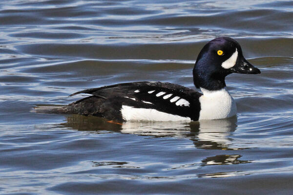
Male Barrow's Goldeneye
Barrow's Goldeneye breeding habitat consists of wooded lakes and ponds in northwestern North America, eastern Canada and Iceland. Females sometimes lay eggs in the nests of other cavity-nesting ducks and it's not uncommon for Barrow's and Common Goldeneyes to hybridize.
Barrow's Goldeneye breeding habitat consists of wooded lakes and ponds in northwestern North America, eastern Canada and Iceland. Females sometimes lay eggs in the nests of other cavity-nesting ducks and it's not uncommon for Barrow's and Common Goldeneyes to hybridize.

Curlews loafing on the largest mowed dike in the Ki’i Unit
Curlews loafing on the largest mowed dike in the Ki’i UnitBristle-thighed Curlews on the largest mowed dike in the Ki’i Unit in James Campbell National Wildlife Refuge on Oahu, Hawaii
Curlews loafing on the largest mowed dike in the Ki’i Unit
Curlews loafing on the largest mowed dike in the Ki’i UnitBristle-thighed Curlews on the largest mowed dike in the Ki’i Unit in James Campbell National Wildlife Refuge on Oahu, Hawaii

Curlews on small island in shallow ponds of the Ki’i Unit
Curlews on small island in shallow ponds of the Ki’i UnitBristle-thighed Curlews on small island in shallow ponds of the Ki’i Unit of the James Campbell National Wildlife Refuge on Oahu, Hawaii.
Curlews on small island in shallow ponds of the Ki’i Unit
Curlews on small island in shallow ponds of the Ki’i UnitBristle-thighed Curlews on small island in shallow ponds of the Ki’i Unit of the James Campbell National Wildlife Refuge on Oahu, Hawaii.

Common Redpolls in a spruce tree in Anchorage, Alaska
Common Redpolls in a spruce tree in Anchorage, AlaskaTwo Common Redpolls sitting in a snow covered spruce tree in Anchorage, Alaska
Common Redpolls in a spruce tree in Anchorage, Alaska
Common Redpolls in a spruce tree in Anchorage, AlaskaTwo Common Redpolls sitting in a snow covered spruce tree in Anchorage, Alaska

Black-capped Chickadee with a deformed beak that has grown long and curved down
Black-capped Chickadee with a deformed beak that has grown long and curved downA Black-capped Chickadee with a beak that has grown long and curved down. Avian keratin disorder (AKD) is a disease characterized by debilitating beak overgrowth and other abnormalities of keratinized tissues. Affected birds have difficulty feeding and preening and may suffer high rates of mortality.

Blue-winged teal in Texas. Inset shows avian influenza virus
Blue-winged teal in Texas. Inset shows avian influenza virusBlue-winged teal in Texas. Inset shows avian influenza virus
Blue-winged teal in Texas. Inset shows avian influenza virus
Blue-winged teal in Texas. Inset shows avian influenza virusBlue-winged teal in Texas. Inset shows avian influenza virus

Alsek River in Southeast Alaska
Alsek River is one of the transboundary watersheds of Southeast Alaska.
Alsek River is one of the transboundary watersheds of Southeast Alaska.

Red-breasted Merganser pair on the North Slope of Alaska
Red-breasted Merganser pair on the North Slope of AlaskaRed-breasted Merganser pair in North Slope of Alaska
Red-breasted Merganser pair on the North Slope of Alaska
Red-breasted Merganser pair on the North Slope of AlaskaRed-breasted Merganser pair in North Slope of Alaska

Panning for Rare Earths
A field assistant pans for monazite and rare earth minerals in Wolf Creek, which cuts through the Melozitna granite. This area is part of the Bureau of Land Management's Central Yukon Planning Area, where USGS did a critical mineral assessment in 2015.
A field assistant pans for monazite and rare earth minerals in Wolf Creek, which cuts through the Melozitna granite. This area is part of the Bureau of Land Management's Central Yukon Planning Area, where USGS did a critical mineral assessment in 2015.

Bristle-thighed Curlew on a fence post on the island of Oahu, Hawaii
Bristle-thighed Curlew on a fence post on the island of Oahu, HawaiiBristle-thighed Curlew on a fence post on the island of Oahu, Hawaii.
Bristle-thighed Curlew on a fence post on the island of Oahu, Hawaii
Bristle-thighed Curlew on a fence post on the island of Oahu, HawaiiBristle-thighed Curlew on a fence post on the island of Oahu, Hawaii.