
Nutrient, Sediment, and Flow
Nutrient, Sediment, and Flow
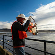
The Chesapeake Bay Program (CBP) is working to reduce nutrients and sediment to improve conditions in the Bay and the health of streams. The USGS, working with partners, monitors nutrients and sediment through a watershed network and works to assess and explain trends. The findings are used to help the CBP address its water-quality goal.
Filter Total Items: 49
USGS Chesapeake Bay Science Accomplishments for 2025
The Chesapeake Bay watershed is home to 18 million people and some of America’s most treasured natural resources – lands, waters, and wildlife that support a strong economy and cherished outdoor traditions, such as hunting and fishing. From local organizations to federal agencies, partners throughout the watershed are working to protect these resources. These partners rely on our unbiased, gold...
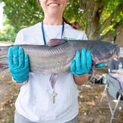
Using monitoring data to measure conditions over time in Chesapeake Bay streams
This study provides a comprehensive assessment of the health of streams throughout the Chesapeake Bay. Monitoring data were used to assess seven key indicators of stream condition, revealing consistent patterns of degradation in urban and agricultural areas. The findings offer critical insights that can inform watershed restoration efforts and improve long-term monitoring strategies.
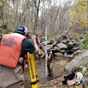
Informing Chesapeake Bay Watershed Management by Monitoring Trends in River Nutrient and Sediment Loads
The USGS has computed nutrient and suspended-sediment loads and trends through water year 2023 in Chesapeake Bay rivers. These monitoring-based estimates help federal, state, and local managers evaluate and plan water-quality restoration strategies.

Discovering Connections Across America's Lands and Waters
Through collaboration and coordination, USGS research helps preserve and restore America’s most iconic landscapes. We apply insights across ecosystems to understand how these systems function and change, helping natural resource managers protect our Nation’s natural heritage for generations to come.
USGS Chesapeake Accomplishments and Highlights for 2024
As a home to 18 million people and a destination for countless visitors seeking recreational opportunities, the health of the Chesapeake Bay watershed is of critical importance. The U.S. Geological Survey (USGS) is a leading provider of data-driven insights about the condition of the watershed’s lands, waters, fish, and wildlife. These insights and our collaborative work with partners throughout...

Susquehanna River Story — What does the science say about water quality?
The wide and majestic Susquehanna River is one of the oldest rivers in the world and provides water for over 4 million people. Despite its beauty, the Susquehanna River and the Chesapeake Bay downstream has been facing the detrimental effects of excess nutrients (nitrogen and phosphorus).

Susquehanna River and Basin
In Pennsylvania, the USGS's water-resources roots date back to the late 1800's, with the initiation of streamflow gaging on the Susquehanna and Delaware Rivers and assessments of groundwater resources near Philadelphia. The USGS Pennsylvania Water Science Center continues to provide scientific information about the water resources of the Susquehanna River Basin, in cooperation with regional and...

Using Multiple Indicators to Assess Stream Condition in the Chesapeake Bay
USGS is working with federal, state and local partners to develop multiple assessments of stream and river conditions in non-tidal areas of the Chesapeake Bay watershed. These assessments will help managers preserve stream health and improve biological conditions in impaired streams as the human population and climate continue to change in this region.

Agricultural and Urban Management Practices have Hidden Costs and Benefits to Stream Health
The findings of the study highlight that management practices can have both hidden costs and benefits to fish and macroinvertebrates depending on regional and local factors like how many and what type of management practices are implemented.

New insights for reducing nutrient and sediment loads in agricultural watersheds prioritized for management activities
Agricultural activities and natural factors may offset nutrient and sediment reductions from management activities.

Phosphorus in the Susquehanna River may be tied to legacy sediment and changing pH
The Susquehanna River is the predominant source of freshwater and nutrients entering the Chesapeake Bay.

Monitoring the Effectiveness of Conservation Practices in Small Agricultural Watersheds
Farmers are an important part of the economy and heritage of the Chesapeake Bay. Farmers also act as stewards of the land and water. Across the Chesapeake Bay Watershed, members of the agricultural community are volunteering to adopt conservation practices on their land. The goal of these practices is to protect the health of the soil, local streams and rivers, and the Chesapeake Bay. These...