U.S. flag

An official website of the United States government

Videos

Videos intro.
Video thumbnail reads: NGWOS AEMs for Illinois. Aerially Mapping The Illinois River Basin NGWOS AEMs For Illinois - Aerially Mapping the Illinois River Basin
NGWOS AEMs For Illinois - Aerially Mapping the Illinois River Basin

The USGS is bringing expertise in the use of airborne electromagnetic (AEM) surveys to support groundwater studies. Like medical imaging allows us to non-invasively measure inside the human body, AEM surveys help to investigate Earth's subsurface without the need for expensive drilling.

The USGS is bringing expertise in the use of airborne electromagnetic (AEM) surveys to support groundwater studies. Like medical imaging allows us to non-invasively measure inside the human body, AEM surveys help to investigate Earth's subsurface without the need for expensive drilling.

Video thumbnail reads: NGWOS AEMs for Illinois. Aerially Mapping The Illinois River Basin. Audio Description. NGWOS AEMs For Illinois - Aerially Mapping the Illinois River Basin (AD)
NGWOS AEMs For Illinois - Aerially Mapping the Illinois River Basin (AD)

The USGS is bringing expertise in the use of airborne electromagnetic (AEM) surveys to support groundwater studies. Like medical imaging allows us to non-invasively measure inside the human body, AEM surveys help to investigate Earth's subsurface without the need for expensive drilling.

The USGS is bringing expertise in the use of airborne electromagnetic (AEM) surveys to support groundwater studies. Like medical imaging allows us to non-invasively measure inside the human body, AEM surveys help to investigate Earth's subsurface without the need for expensive drilling.
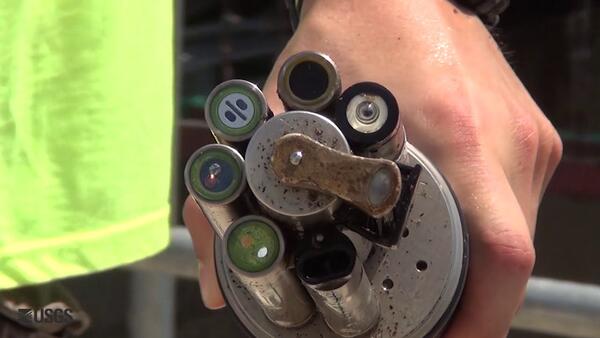
USGS Continuous Nutrient Monitoring in the Mississippi River Basin

USGS “supergages” are very complex. Continuous concentrations of nutrients and streamflow are measured at supergages and the information is available to the public in real-time.

USGS “supergages” are very complex. Continuous concentrations of nutrients and streamflow are measured at supergages and the information is available to the public in real-time.

The Phragmites Adaptive Management Framework (PAMF)

This is an introductory video to an adaptive management approach for the invasive plant Phragmites australis in the Great Lakes basin. An adaptive management framework is an iterative process of robust decision making aimed at reducing uncertainty over time, for a variety of stakeholders with differing backgrounds and interests, via system monitoring.

This is an introductory video to an adaptive management approach for the invasive plant Phragmites australis in the Great Lakes basin. An adaptive management framework is an iterative process of robust decision making aimed at reducing uncertainty over time, for a variety of stakeholders with differing backgrounds and interests, via system monitoring.

Timelapse of Brandon Road Lock during USGS Dye Study

This is a timelapse video of a dye tracer study at Brandon Road Lock, a U.S. Army Corps of Engineers (USACE) facility in Joliet, IL, on the Des Plaines River on October 20, 2015.

This is a timelapse video of a dye tracer study at Brandon Road Lock, a U.S. Army Corps of Engineers (USACE) facility in Joliet, IL, on the Des Plaines River on October 20, 2015.

Visualizing Flow Through the Brandon Road Lock & Dam

This video portrays two areas near the Brandon Road Lock and Dam, a US Army Corps of Engineers facility in Joliet, IL. This video was collected as the lock was emptied through the downstream valves, refilled with water, and then emptied again. This data collection is supporting efforts to combat the spread of invasive Asian carp into the Great Lakes Basin.

This video portrays two areas near the Brandon Road Lock and Dam, a US Army Corps of Engineers facility in Joliet, IL. This video was collected as the lock was emptied through the downstream valves, refilled with water, and then emptied again. This data collection is supporting efforts to combat the spread of invasive Asian carp into the Great Lakes Basin.

Was this page helpful?