
Plenty of Water in Prairie Potholes
Annual NLCD reveals how surface water has expanded in this wetlands region of North and South Dakota
The landscape of the Prairie Pothole Region of North and South Dakota formed when glaciers from the last ice age receded. The potholes are shallow depressional wetlands left behind by the glaciers now popular with migratory waterfowl.
Floods in this region subside slowly due to the flat terrain. One season’s high water carries over into the next year, amplifying the problem of flooding (NASA, 2020). The expansion of these surface waters has been well documented (Damaschen and Galloway, 2016; Nustad et al., 2016; Renton et al., 2015; Vanderhoof and Alexander, 2016; Vecchia, 2011).
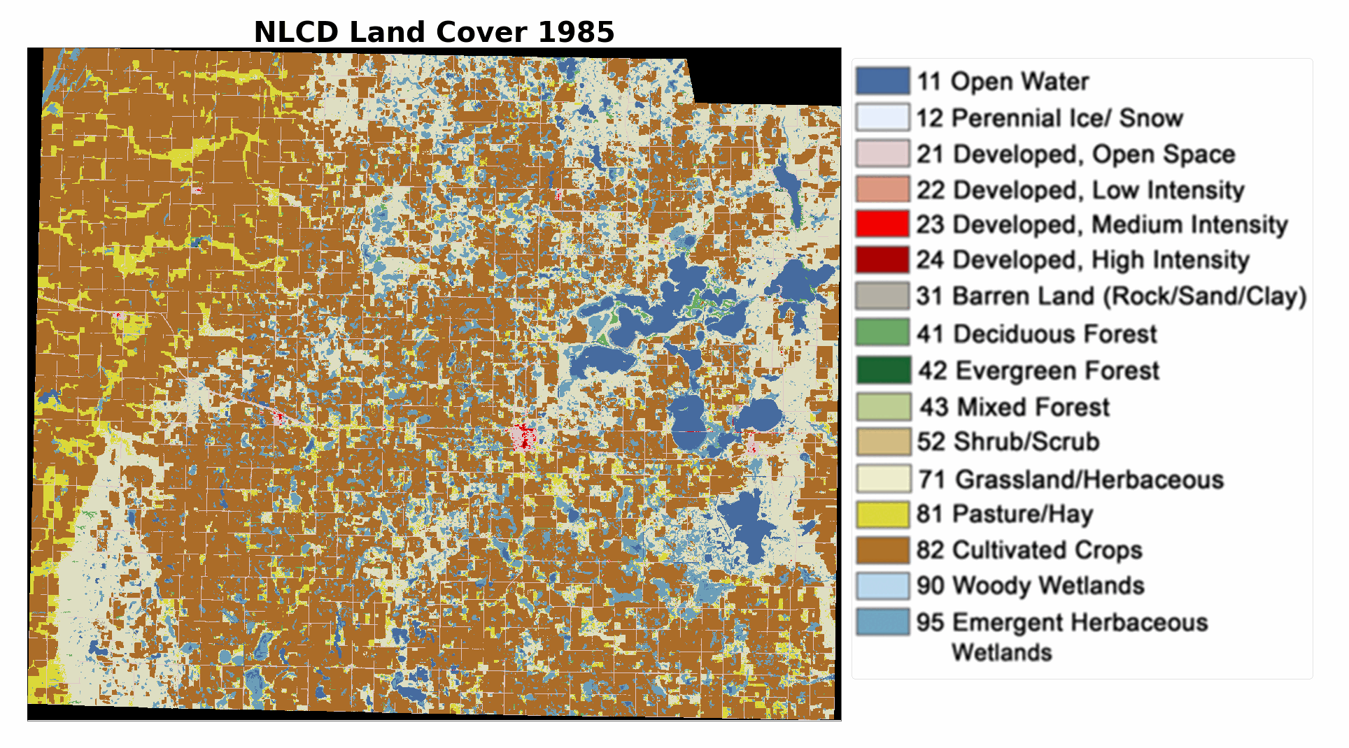
The U.S. Geological Survey’s Annual National Land Cover Database (NLCD), based on Landsat satellite imagery, offers an effective way to visualize rising waters. The land cover class of “open water” is a minor but still important one for the lower 48 states as a whole, dominated by the Great Lakes and the coastal water zone. In the Prairie Pothole Region, surface water expansion in recent decades is a complex story.
Dynamics of Prairie Potholes
Surface water in the prairie potholes is highly responsive to both air temperature and precipitation (Renton et al., 2105). In addition, a strong connection between groundwater and potholes is described as filling and subsequently spilling (Vanderhoof et al., 2016). When aquifers are full, surface water recedes slowly. Throughout the Dakotas, recent wet periods may be a part of natural variability that is likely to be repeated over longer time spans (Nustad et al., 2016; Ryberg et al., 2016; Liu and Schwartz, 2011).
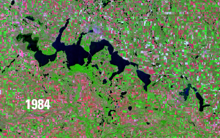
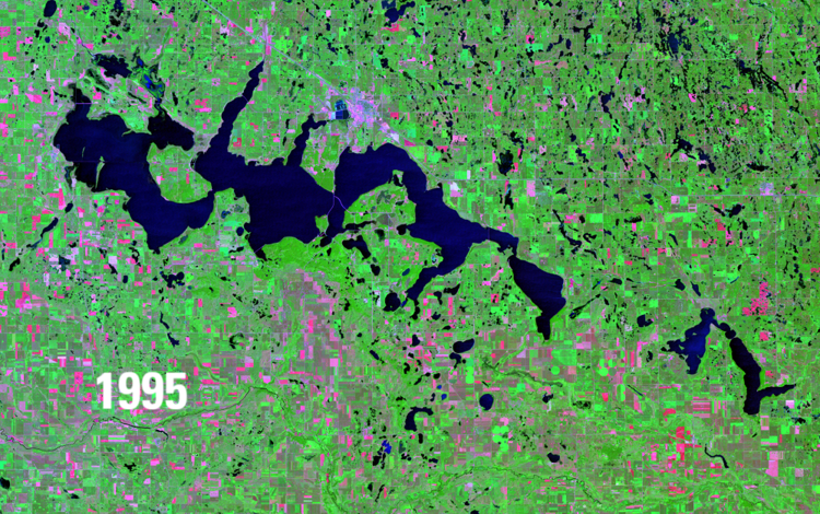
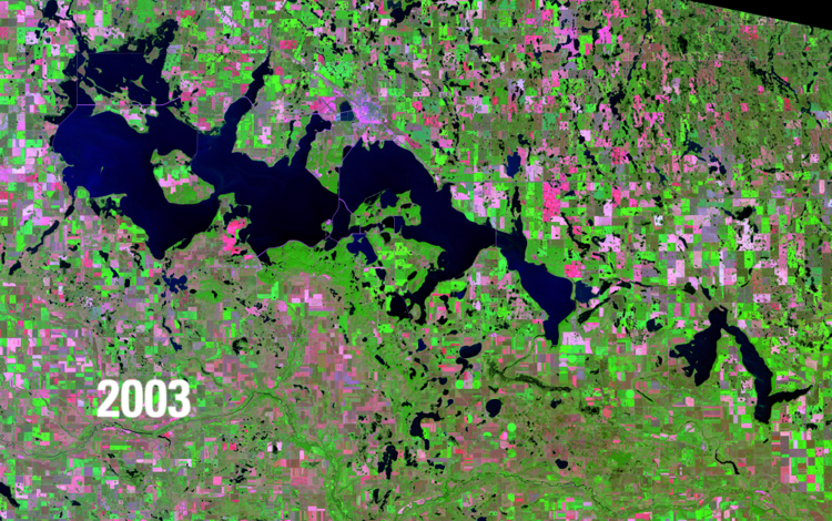
Thirty-nine years of Annual NLCD land cover provide two good visual examples of prairie pothole flooding events: the Devils Lake area in northeastern North Dakota and Day County in northeastern South Dakota. Lakes, potholes and wetlands in those areas saw large increases in open water (Newsdakota.com, 2020).
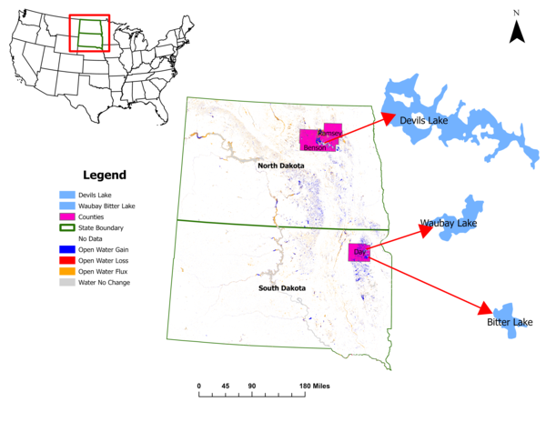
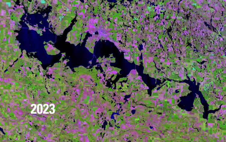
Right: This map shows open water in North Dakota and South Dakota from 1985 to 2023. The colors indicate whether the open water areas gained or lost water, fluctuated between gains and losses or remained unchanged during that time period. Areas of special interest to this article are Devils Lake in North Dakota and Waubay Lake and Bitter Lake in South Dakota.
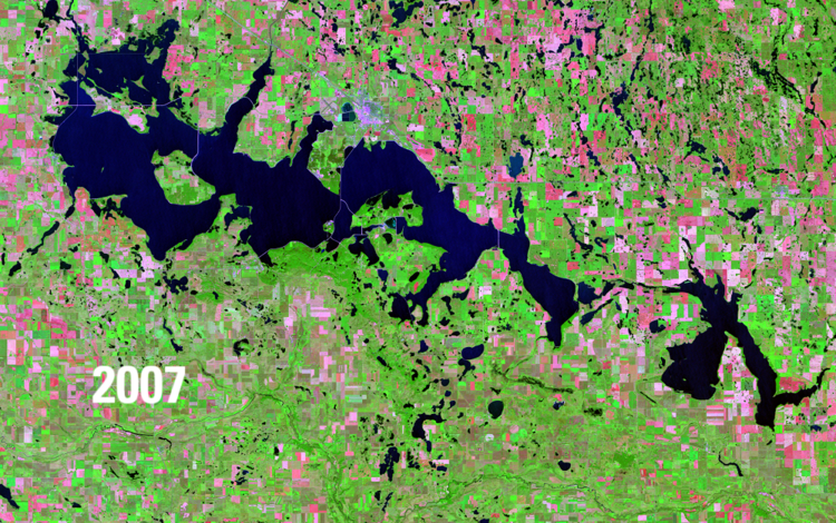
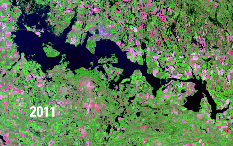
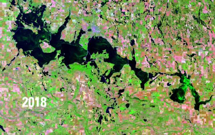
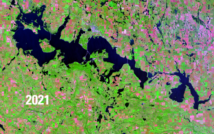
Devils Lake, North Dakota
Devils Lake is a closed-basin lake without a natural outlet (Todhunter, 2021). Devils Lake has experienced broad variation between high and low water levels. Flooding after precipitation events combined with runoff from a series of other lakes has intensified over the years (Todhunter, 2018; Vanderhoof et al., 2016). The lake typically loses water only from evaporation and seepage (Renton et al., 2015). Since 1993, homes, businesses and agricultural lands have experienced flooding, and some roads have closed permanently.
In these Landsat satellite images below from USGS Earthshots beginning with 1984, expansion of surface water in the greater Devils Lake area in northeastern North Dakota can be viewed (U.S. Geological Survey, 2022).
Increased precipitation is only part of the story. The conversion of the Dakota prairies and potholes to agriculture through man-made drainage of wetlands has amplified flooding (Todhunter, 2018). The natural flow of water has been altered by tiles, pipes and ditches that move water out of wetlands, leaving the land dry enough for row crops (Johnston, 2013). This drainage combined with increased precipitation leads to surface water increases in adjacent wetlands and lakes (Vanderhoof et al., 2017).
In the greater Devils Lake area, drainage of the basin’s wetlands has caused water to move into the lake faster. As water levels in the lake increase, wetlands are subsumed, leading to surface water expansion (Vanderhoof and Alexander, 2016).
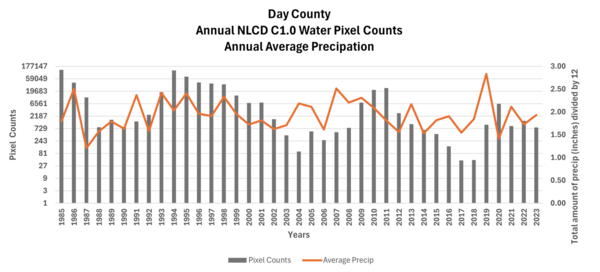
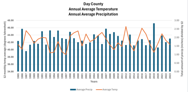
Day County, South Dakota
Day County in South Dakota is relatively flat, with the Waubay Lake chain consisting of eight basins separated by low divides. This area has experienced a series of wet years (Auch, 2015).
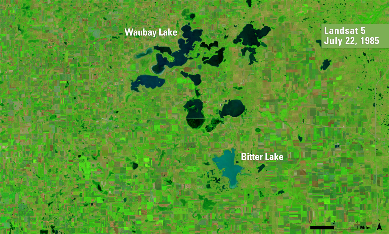
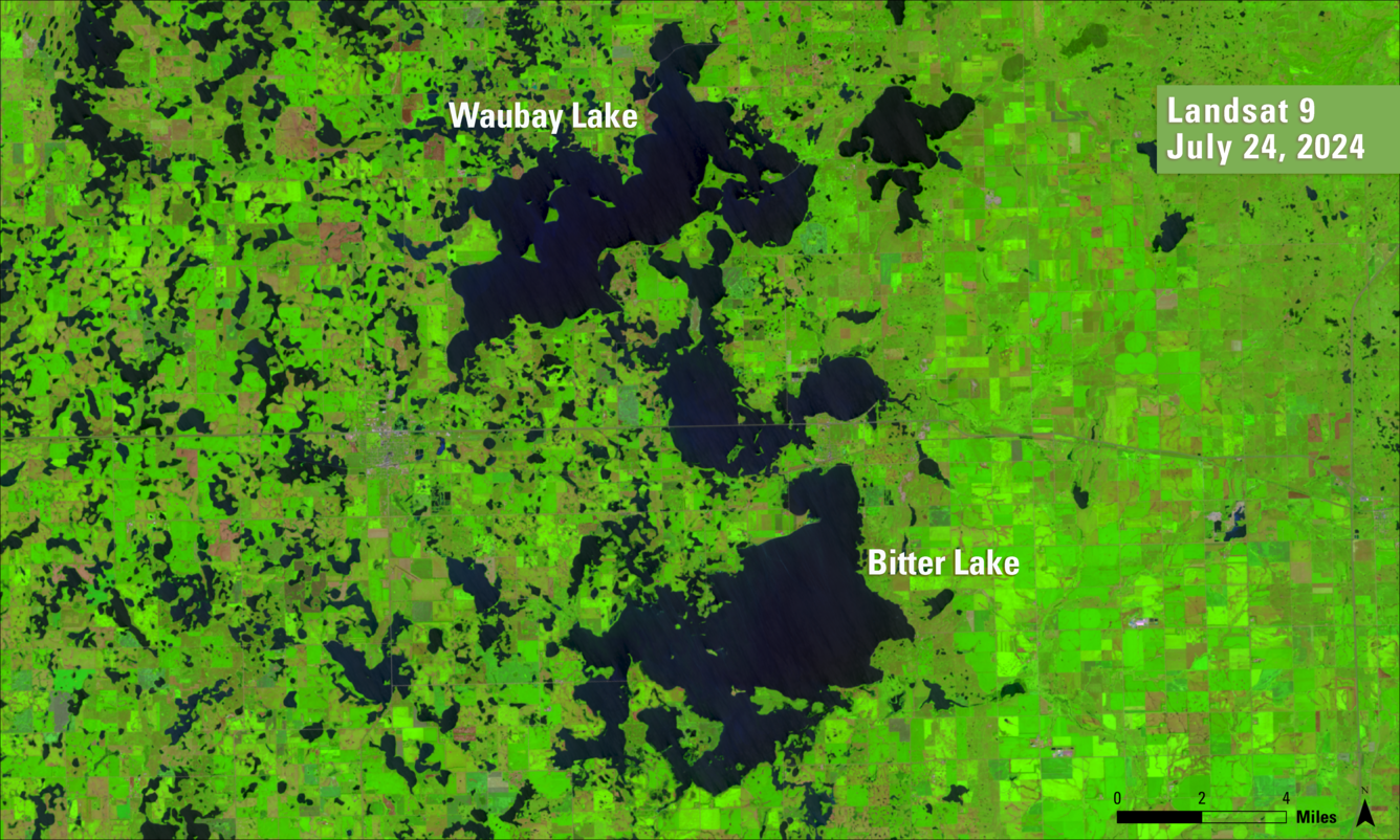
Large precipitation events led to persistent flooding and long-standing wet conditions (Shapley and others, 2005). Groundwater well levels also rose. The filling and spilling of these lakes and surrounding potholes will continue to intensify with the conversion of native prairie and wetlands to cropland.
Effects and Monitoring
Water quality issues arise with surface water expansion as a high concentration of nutrients wash out of agriculture fields into wetlands, lakes and populated areas (Baulch and others, 2019). On the other hand, surface water expansion can create new recreational opportunities with enhanced sport fishing in expanded or “created” lakes (Blackwell and others, 2020).
Overall, the power of USGS sustained satellite observations in remote sensing of the United States and land cover mapping can show the dynamics of land cover change over time. Landsat satellites and Annual NLCD enable researchers engaged in land change studies, land managers and residents to better understand various natural resource impacts of land cover and land use change.
About Annual NLCD
More Land Change Stories
References:
Auch, R.F., 2015. Chapter 7, northern glaciated plains ecoregion. In Status and Trends of Land Change in the Great Plains of the United States—1973 to 2000, Taylor, J.L., Acevedo, W., Auch, R.F., and Drummond, M.A. pp. 69-76. U.S. Geological Survey Professional Paper 1794-B, Reston, Va.
Baulch, H.M., Elliott, J.A., Corderio, M.R.C., Flaten, D.N., Lobb, D.A., and Wilson, H.F., 2019. Soil and water management: opportunities to mitigate nutrient losses to surface waters in the Northern Great Plains. Environ. Rev. 27: 447–477. https://cdnsciencepub.com/doi/10.1139/er-2018-0101
Blackwell, B.G., Smith, B.J., Kaufman, T.M., and Moos, T.S., 2020. Use of a restrictive regulation to manage walleyes in a new glacial lake in South Dakota. North American Journal of Fisheries Management 40:1202–1215. https://onlinelibrary.wiley.com/doi/abs/10.1002/nafm.10486
Damschen, W.C., and Galloway, J.M., 2016, Water-surface elevation and discharge measurement data for the Red River of the North and its tributaries near Fargo, North Dakota, water years 2014–15: U.S. Geological Survey Open-File Report 2016–1139, 16 p., https://pubs.usgs.gov/publication/ofr20161139
Hoogestraat, G.K., and Stamm, J.F., 2015, Climate and streamflow characteristics for selected streamgages in eastern South Dakota, water years 1945–2013; U.S. Geological Survey Scientific Investigations Report 2015–5146, 35 p., with appendix, https://pubs.usgs.gov/publication/sir20155146
Johnston, C.A., 2013, Wetland Losses Due to Row Crop Expansion in the Dakota Prairie Pothole Region; Natural Resource Management Faculty Publications, 95.https://openprairie.sdstate.edu/nrm_pubs/95/
Liu, G. and Schwartz, F.W., 2011, An integrated observational and model-based analysis of the hydrologic response of prairie pothole systems to variability in climate; Water Resources Research, 47, W02504, https://agupubs.onlinelibrary.wiley.com/doi/full/10.1029/2010WR009084
NASA, 2020, https://earthobservatory.nasa.gov/images/146515/relentless-floods
Newsdakota.com, 2020, https://www.newsdakota.com/2020/08/07/excess-water-continues-to-plague-prairie-pothole-region/
National Centers for Environmental Information (NOAA), 2025, Climate at a Glance: National Time Series, published May 2025, accessed May 8, 2025, from https://www.ncei.noaa.gov/access/monitoring/climate-at-a-glance/national/time-series
Nustad, R.A., Kolars, K.A., Vecchia, A.V., and Ryberg, K.R., 2016, 2011 Souris River flood—Will it happen again?; U.S. Geological Survey Fact Sheet 2016–3073, 4 p., https://pubs.usgs.gov/publication/fs20163073
Renton, D.A., Mushet, D.M., and DeKeyser, E.S., 2015, Climate change and prairie pothole wetlands—Mitigating water-level and hydroperiod effects through upland management: U.S. Geological Survey Scientific Investigations Report 2015–5004, 21 p., https://pubs.usgs.gov/publication/sir20155004
Ryberg, K.R., Vecchia, A.V., Akyüz, F.A., and Lin, W., 2016, Tree-ring-based estimates of long-term seasonal precipitation in the Souris River Region of Saskatchewan, North Dakota and Manitoba, Canadian Water Resources Journal / Revue canadienne des ressources hydriques, 41:3, 412-428, 17 p., https://www.tandfonline.com/doi/full/10.1080/07011784.2016.1164627
Shapley, M.D., Johnson, W.C., Engstrom, D.R., and Osterkamp, W.R., 2005, Late-Holocene flooding and drought in the Northern Great Plains, USA, reconstructed from tree rings, lake sediments and ancient shorelines. The Holocene, 15 (1): 29-41.
Todhunter, P.E. 2018, A volumetric water budget of Devils Lake (USA): non-stationary precipitation–runoff relationships in an amplifier terminal lake. Hydrological Sciences Journal, vol. 63 (9):1275–1291. https://www.tandfonline.com/doi/full/10.1080/02626667.2018.1494385
Todhunter, P.E., 2021, Hydrological basis of the Devils Lake, North Dakota (USA), terminal lake flood disaster. Nat Hazards 106, 2797–2824 (2021). https://link.springer.com/article/10.1007/s11069-021-04567-2
USGS Earth Resources Observation and Science (EROS) Center, 2022, Lake levels rise: U.S. Geological Survey Earthshots webpage, 2022, accessed online 6/26/2025, at https://eros.usgs.gov/earthshots/lake-levels-rise
Vanderhoof, M.K., Alexander, L.C., and Todd, M.J., 2016a, Temporal and spatial patterns of wetland extent influence variability of surface water connectivity in the Prairie Pothole Region, United States; Landscape Ecology 31, 805–824 (2016). https://link.springer.com/article/10.1007/s10980-015-0290-5
Vanderhoof, M.K., and Alexander, L.C., 2016b, The Role of Lake Expansion in Altering the Wetland Landscape of the Prairie Pothole Region, United States; Wetlands 36 (Suppl 2), 309–321. https://link.springer.com/article/10.1007/s13157-015-0728-1
Vanderhoof, M.K., Christensen, J.R. and Alexander, L.C., 2017, Patterns and drivers for wetland connections in the Prairie Pothole Region, United States; Wetlands Ecology and Management 25, 275–297. https://link.springer.com/article/10.1007/s11273-016-9516-9
Vecchia, Aldo V., 2011, Simulation of the effects of Devils Lake outlet alternatives on future lake levels and water quality in the Sheyenne River and Red River of the North; 2011; SIR; 2011-5050.
Wimberly, M.C., Janssen, L.L., Hennessy, D.A., Luri, M., Chowdhury, N.M., and Feng, H., 2017, Cropland expansion and grassland loss in the eastern Dakotas: New insights from a farm-level survey; Land Use Policy, Volume 63, Pages 160-173.
Related
Visit the Annual National Land Cover Database (NLCD) website to learn more.

Annual National Land Cover Database
Read articles about Annual NLCD and examples of its uses.
Annual NLCD Collection 1.2 Now Available Annual NLCD Collection 1.2 Now Available
Related
Visit the Annual National Land Cover Database (NLCD) website to learn more.
Annual National Land Cover Database
Read articles about Annual NLCD and examples of its uses.