An official website of the United States government
Here's how you know
Official websites use .gov
A .gov website belongs to an official government organization in the United States.
Secure .gov websites use HTTPS
A lock () or https:// means you’ve safely connected to the .gov website. Share sensitive information only on official, secure websites.
We become intimately familiar with the land where we live, work and play. The backyard maple where three baby robins left their nest on the fourth branch up this summer. The depression in a farm field that frequently stays too wet for a good yield. The patch of prairie in a favorite state park where wildflowers bloom freely.
With open eyes, we absorb the finest details of our surroundings, but confined to the ground, we miss a much bigger picture.
Aerial photographs provided an early way to view portions of the land on a grander scale—to see from above not just a few trees but a forest, or the lay of the land across a field. Mapping what covered the land, or the ways in which land was used, could provide economic and conservation insights to states, organizations and researchers.
When the space-based remote sensing era came along in the 1970s, it offered the potential to map land cover more completely and less expensively. The USGS Earth Resources Observation and Science (EROS) Center, celebrating its 50th anniversary this year, was developed at the beginning of the Landsat Earth observation satellite program as a place to store and distribute the imagery. Through the years, EROS has become much more—including a place to advance land cover mapping and monitoring through an unbiased scientific lens.
USGS EROS research geographer Jesslyn Brown explains the concept: “Land cover includes describing the type and geographical patterns of features like vegetation, bare soil or rock; developed surfaces like those in urban situations, such as roads; and agriculture.”
One significant land cover effort at EROS began in the mid-1970s, soon after the 1972 launch of Landsat 1, as a collaboration between EROS and its home state of South Dakota. The South Dakota Cooperative Land Use Effort involved the State Planning Bureau and EROS working together to create an ongoing Land Use and Natural Resource Inventory and Information System Program using Landsat data, along with high-altitude and low-altitude photography in areas where more detail was desired.
A 1978 mosaic of South Dakota made from Landsat 1 and 2 scenes.
Examples of anticipated uses of the inventory included state policy on land use and natural resource management, planning related to local land use and flood plain delineation, environmental monitoring of water quality and wildlife habitat, agricultural crop inventories and disease monitoring, and economic development issues such as land capability and transportation corridors.
Many agencies and universities didn’t yet have computing power for the digital age in the 1970s. Former EROS Chief Scientist Tom Loveland reminisced in March 2022 about starting his first job in 1976 at the South Dakota State Planning Bureau, when he worked to remake the Landsat photographic map of land cover for South Dakota—one of the first states to do a photographic map—with Landsat data on computer-compatible tapes.
“South Dakota rapidly invested in developing the capability to analyze the digital imagery,” Loveland said. “South Dakota was another pioneer in mapping at a very detailed level, about an acre’s resolution, land use across the state.”
Mapping from Areas in the U.S. to Africa
Also in the 1970s, EROS started working with other federal agencies on cooperative mapping projects. In a pilot program later in the decade, for example, the Bureau of Land Management (BLM) wanted to classify different types of vegetation in Denali National Park. EROS researchers helped increase BLM managers’ confidence in the interpretation of wilderness satellite data by traveling to Alaska to record vegetation and terrain conditions on sample plots to compare to Landsat imagery. This was followed by the BLM cooperative project Arizona Vegetation Resources Inventory, classifying vegetation in states along the Colorado River.
A 1987 mosaic of the United States using AVHRR data.
EROS identified similar land cover classification projects for agencies such as the National Park Service, the Bureau of Indian Affairs and the U.S. Fish and Wildlife Service and helped broaden their capabilities of using Landsat data.
In the 1980s, as EROS began its International Program, a different type of satellite data factored in. The Advanced Very High Resolution Radiometer (AVHRR) sensor aboard National Oceanic and Atmospheric Administration (NOAA) meteorological satellites could cover the entire Earth in one day at a coarse scale and reveal information about vegetation cover and conditions.
EROS scientist Don Moore started acquiring AVHRR data on tapes from NOAA to put together greenness maps of the Sahel region of Africa. The maps monitored the area’s vegetation for signs of drought and potential locust outbreak conditions. The idea of using AVHRR for U.S. research, too, led to the 1987 installation of an AVHRR antenna on the EROS roof so reception and processing of data from the conterminous United States and much of Canada and Mexico could be done onsite. Regional collaborative greenness mapping projects began looking for U.S. drought and fire danger conditions in the AVHRR data. The National Weather Service, for example, was an early user of AVHRR-based greenness to estimate fire danger.
And then came the ambitious land cover project that led Brown to EROS more than 30 years ago.
First, a Map of the Entire U.S.—and Then the World
Brown came aboard a team, including Loveland, that started working in 1991 to create the first 1-km resolution land cover map and database of the conterminous United States using AVHRR data. This soon evolved into an 18-month collection of time series 1-km global AVHRR imagery, and work after that led to the first 1-km global land cover data set.
USGS research geographer Jesslyn Brown works early in her career, in about 1992, at the USGS Earth Resources Observation and Science (EROS) Center on land cover science and mapping.
These products were highly anticipated and intended to fill a void in global information. Loveland had connected with the International Geosphere-Biosphere Program, which was concerned about the lack of sufficient global land cover data in the face of changing landscapes that included deforestation, desertification, agricultural production, carbon cycle modeling, flood risk and more.
“It was a huge amount of work, although given what we’re tackling today, I don’t know if I’d say it was easier then,” Brown said. “We were pathfinding. We were doing things that hadn’t been done before. So there was a lot of experimentation.”
“I see those two efforts—1 kilometer conterminous U.S. mapping and then the global 1 kilometer—as being really foundational to many, many mapping efforts today,” Brown added.
Examples of applications of the global database included the World Resource Institute Global Watersheds Vulnerability Assessment, the United Nations Food and Agriculture Organization Global Forest Resources Assessment and the National Geographic Society Satellite Atlas of the World.
USGS EROS science staff, including Jesslyn Brown, developed a 1-km resolution global land perspective using AVHRR data.
“In the 1990s, there were fewer players in this arena of mapping land cover. And because of the efforts of the conterminous U.S. land cover mapping at 1 kilometer, EROS had demonstrated our capacity and capability to map. So, I believe we established a reputation from that initial mapping effort that then allowed us to expand,” Brown said. “We felt the pressure to do it right and to give people the highest quality data that we could.”
A New Partnership, a Flagship National Database
Alongside the AVHRR land cover mapping projects, a new land cover effort based at EROS arose in the early 1990s.
The Multi-Resolution Land Characteristics (MRLC) Consortium began as a partnership among the USGS, Environmental Protection Agency (EPA) and NOAA, and soon after the U.S. Forest Service, to pool resources to purchase Landsat imagery to meet the agencies’ land characterization and environmental assessment needs. In addition to the 1-km global database, the partnership aimed to develop a 30-m resolution regional land characteristics database using primarily Landsat data from about 1992 and set up a multi-resolution system to monitor land cover change.
The regional land characteristics were released incrementally for use by the agencies, with the long-term goal being the production of a national 30-m database. Based on Landsat 5 imagery, this would provide the most detailed data ever collected for a national land cover program. The data release for the National Land Cover Database (NLCD) 1992 Land Cover Conterminous United States occurred in 2000, but the EROS project team’s work and collaboration with other agencies did not end there.
The first National Land Cover Dataset, NLCD 1992, was based on Landsat 5 data.
A next-generation NLCD was planned that would add Landsat 7 data to create a more complete land cover product and include the daunting wilderness of Alaska. USGS EROS Physical Scientist Jon Dewitz now serves as the NLCD acting project manager but started working with NLCD in 2001 under the leadership of Collin Homer. Time has not faded the memory of the work Dewitz put into the next generation NLCD product, called NLCD 2001, released in its final version in 2007.
There were significant differences between NLCD 1992, which was “widely recognized and very used,” and NLCD 2001, Dewitz said.
NLCD 1992 used mostly manual techniques to produce a single land cover product, he said. The NLCD 2001, based largely on 2001 imagery, was a database created with more automated interpretation that included percentages of forest canopy, developed area and impervious surface in addition to land cover to be more informative at a smaller scale. In addition, NLCD 1992 classified more by different land usages—such as a rail corridor—than by satellite-detected land cover conditions such as grassland or impervious surface, which can fit multiple types of usages.
EROS scientist Jon Dewitz has spent time in Alaska (shown here) and elsewhere doing field work for the National Land Cover Database (NLCD).
Dewitz started out doing quality assurance and quality control for NLCD 2001’s training data, to help get a more accurate assessment of the land cover in the satellite imagery. Training data used higher-resolution aerial photography products in the EROS archive. Dewitz also did field work, going out to sample areas to verify accuracy and solve mysteries in the satellite data—such as whether vegetation was shrub or herbaceous, like grasses.
A field trip to California solved a couple of real puzzlers. Fields showing up bright red and yellow on imagery were actually filled with tulips. And peculiar white fields turned out not to contain alkaline soil, or some other natural phenomenon. “We finally found one, and they were cutting grapes off, putting them on a white paper towel and setting them on the ground to dry into raisins. So this whole field, we’ve got these little white patches sitting on the ground that made the whole field look white in the imagery,” Dewitz said.
There was no high-resolution imagery to fall back on for training data in Alaska, Dewitz said, so that required him to spend a lot of time flying or driving around the state’s remote areas with an Alaska-based USGS researcher, Dave Selkowitz, to collect the training data. From tent camping to sleeping in a room of 30 bunks, he saw more of Alaska than most. “It was definitely an adventure,” he said.
Evolution of NLCD and Creation of Other Projects
NLCD, which stands as the definitive land cover database for the United States, has released updates since the 2001 version, and NLCD 2021 was released in July 2023. NLCD is used as an input in many ways by state and federal agencies, researchers and organizations. The diversity of use cases is staggering, from supporting analysis of the flow of waterborne pollutants to assessing carbon dynamics in ecosystems on land, and from modeling wildlife distributions to predicting disease vectors.
“NLCD gets a lot of usage from the private sector and from the university sector, and it can be a starting point for many other maps and use cases,” Dewitz said.
At the same time, land cover projects at other agencies now complement the NLCD, and vice versa. While the USGS, through EROS, originally generated forest canopy data, now the U.S. Forest Service provides it. The U.S. Department of Agriculture delineates the types of crops grown in farm fields and can rely on NLCD for cover outside of agricultural areas. Work at EROS that has evolved into the Rangeland Condition Monitoring, Assessment and Projection (RCMAP) provides information about the shrub and grassland areas of the western United States with more detail than NLCD provides.
A map showing the LANDFIRE 2020 Existing Vegetative Type across the United States.
NLCD data gets adapted for use in North American Land Change Monitoring System (NALCMS) products as well, which USGS EROS produces in collaboration with organizations in Canada and Mexico. The 2020 NALCMS land cover map was just released this year, on a five-year schedule that began with the initial 2005 version.
Soon after work began on the NLCD 2001 product, a more specialized land cover-type project started working on a prototype at EROS. A partnership between the Department of the Interior and the U.S. Forest Service led to the creation of LANDFIRE (Landscape Fire and Resource Management Planning Tools) to benefit the agencies’ wildland fire management programs. LANDFIRE offers detailed information about disturbances and fuel conditions on the land, in addition to vegetation, that is widely used by fire and land managers.
With a now 50-year historical record, the Landsat archive has enabled people to characterize change to the Earth’s surface over a long time period, whether they’re peering around the globe or just a certain state or region. One example capitalized on EROS’ long history with projects in Africa, culminating in the “Landscapes of West Africa: A Window on a Changing World” atlas and dataset that show land change from 1975 to 2000 and 2013 using Landsat, CORONA and MODIS satellite imagery from the archive at EROS.
Modeled land cover for the Delaware River Basin from 1700 through 2100. The full map of the basin depicts land cover from the 2016 National Land Cover Database.
Another land change project at EROS peers into the future, using NLCD and Land Change Monitoring, Assessment and Projection (LCMAP) as a basis. The FOREcasting SCEnarios of Land-use Change (FORE-SCE) modeling framework has been used for modeling historical and future change (1680 to 2100) in the Delaware River Basin, multiple future climate and land use scenarios in the Great Plains, and future land use and land cover projections for the entire conterminous United States. These kinds of projections can help scientists and resource managers with planning for scenarios such as changing water resources and urban growth.
Future of Land Cover Mapping at USGS EROS
Perhaps the most significant development in EROS land cover to affect NLCD is the LCMAP project. LCMAP started in 2014 with the ambition of mining the entire Landsat archive to provide a year-by-year look at changing conditions in land cover across the United States since 1985. LCMAP annual products of land cover and land cover change provide insight into when changes occurred and how significant they were.
The next phase of land cover research at EROS is focused on developing annual land cover and land cover change information with the thematic and geospatial detail NLCD is known for. The initial 2024 product release will provide annual time steps through 2023 for the conterminous United States.
Dewitz is eager to see the results and thinks the time-series analysis based on the entirety of the Landsat archive demonstrated by LCMAP linked with some of NLCD’s class structure will be a powerful combination. “I’m very much looking forward to that new yearly land cover and seeing some of the trends and new insights we can learn from that data. That’s going to be very exciting,” he said.
Dewitz said that the job of USGS scientists, including at EROS, is to “follow the best scientific practices so that, regardless of who’s using the data, they can look at it and know that it is accurate and that it is unbiased.
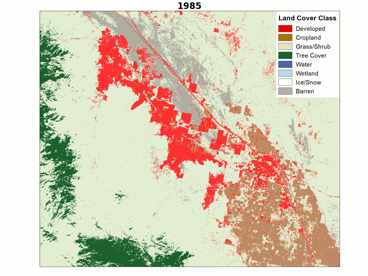
Land cover animation of growth in the Palm Springs, CA area.
“Both the LCMAP and NLCD team, all the folks care and are passionate about what we’re doing and about the impact that we make and give back,” Dewitz added. “Nobody does science for the money. People do science because of something they believe in, and they think is the right thing to do. And that’s really what keeps both projects relevant and important and thriving.”
Early land cover work by EROS scientists paved the way for the projects of today.
“A lot of these early mapping efforts led EROS to have an incredibly strong science department and to perform work that is strongly rooted in user requirements where we focus on transparency, repeatability, robust accuracy assessment, and continuous improvement of land cover mapping and monitoring,” said Brown, who serves as the project manager for the NLCD and LCMAP merger.
“Certainly, LCMAP is rooted in that foundation. In LCMAP, we focused on change and annual change of land cover across the country,” she said. “And Tom Loveland has said many times, it's not just about cover and one-time mapping of land cover, it's about determining what change is happening on the landscape, when it's happening and what are the causes and consequences of those changes.”
The National Land Cover Database (NLCD) has a long history as the definitive U.S. land cover product. But the newer Land Change Monitoring, Assessment and Projection (LCMAP) effort takes a longer look back in time. In this episode of Eyes on Earth, we learn how the two projects at EROS, both based on 30-meter resolution Landsat satellite data, are merging to bring the strengths of each to future...
Eyes on Earth Episode 106 – EROS 50th: Land Cover, Part 1
Several decades ago, USGS EROS employees were pioneers in land cover mapping—turning satellite imagery into a record of what covers the land, from farmland to forest to urban areas. National and global datasets with a variety of uses resulted from these efforts.
Several decades ago, USGS EROS employees were pioneers in land cover mapping—turning satellite imagery into a record of what covers the land, from farmland to forest to urban areas. National and global datasets with a variety of uses resulted from these efforts.
For 50 years, the people of EROS have overcome difficulties and celebrated triumphs together, always centered on providing a perspective of the Earth that helps us better understand its condition. This video, timed with the 50th anniversary celebration at EROS in August of 2023, explores the center's history.
For 50 years, the people of EROS have overcome difficulties and celebrated triumphs together, always centered on providing a perspective of the Earth that helps us better understand its condition. This video, timed with the 50th anniversary celebration at EROS in August of 2023, explores the center's history.
Eyes on Earth Episode 69 - Thirty Years of Land Change in the U.S.
Land change is a constant. Even land areas that see little major change can see disruptions from storms, heat waves, wildfires, or invasive species. But major changes aren't uncommon, either. Each year in the U.S., farm fields become tracts of suburban homes, wetlands become more permanent bodies of water, and shrublands burn to be replaced with grasslands.
Land change is a constant. Even land areas that see little major change can see disruptions from storms, heat waves, wildfires, or invasive species. But major changes aren't uncommon, either. Each year in the U.S., farm fields become tracts of suburban homes, wetlands become more permanent bodies of water, and shrublands burn to be replaced with grasslands.
The rangelands of the western United States are changing more quickly than many other parts of the lower 48. Miles upon miles of the area or semi-arid landscapes in states like Idaho, Montana and Nevada are now carpeted by fire fueling invasive grasses. Cheatgrass is the most prevalent, which is troublesome for several reasons.
The rangelands of the western United States are changing more quickly than many other parts of the lower 48. Miles upon miles of the area or semi-arid landscapes in states like Idaho, Montana and Nevada are now carpeted by fire fueling invasive grasses. Cheatgrass is the most prevalent, which is troublesome for several reasons.
Eyes on Earth Episode 56 - Modeling the Past to Plan for the Future
Mapping land cover in the United States in the present isn’t a simple job, but satellites like Landsat make it possible. Mapping conditions in the pre-satellite era, which the LANDFIRE program does through its Biophysical Settings (BpS) GIS data products, is a far trickier proposition.
Mapping land cover in the United States in the present isn’t a simple job, but satellites like Landsat make it possible. Mapping conditions in the pre-satellite era, which the LANDFIRE program does through its Biophysical Settings (BpS) GIS data products, is a far trickier proposition.
Eyes on Earth Episode 54 - National Land Cover Database 2019
The National Land Cover Database, or NLCD, was the first and remains the most well-known set of satellite-based land cover mapping products released by EROS. It sorts the each 30-by-30-meter plot of land in the United States into a land cover class, such as cropland, pasture, high-intensity developed, deciduous forest, and the like.
The National Land Cover Database, or NLCD, was the first and remains the most well-known set of satellite-based land cover mapping products released by EROS. It sorts the each 30-by-30-meter plot of land in the United States into a land cover class, such as cropland, pasture, high-intensity developed, deciduous forest, and the like.
The fire science community is always on the lookout for the freshest satellite-derived fire disturbance maps. Aiming to meet those needs, the multi-agency partnership known as LANDFIRE has just released an update that adds three new years of disturbances across the U.S. to its 20-plus layers of GIS data.
The fire science community is always on the lookout for the freshest satellite-derived fire disturbance maps. Aiming to meet those needs, the multi-agency partnership known as LANDFIRE has just released an update that adds three new years of disturbances across the U.S. to its 20-plus layers of GIS data.
About 15 million people rely on the Delaware River Basin for drinking water, including residents of Philadelphia, PA, Camden, NJ, and Wilmington, DE. What might happen to the water supply if climate change and population growth continue unabated? How might that impact land cover and land use patterns?
About 15 million people rely on the Delaware River Basin for drinking water, including residents of Philadelphia, PA, Camden, NJ, and Wilmington, DE. What might happen to the water supply if climate change and population growth continue unabated? How might that impact land cover and land use patterns?
The extensive rangelands across the Western United States are threatened by invasive grasses, climate change, and altered fire regimes that can disturb the landscape. The largely semi-arid lands are also important for the survival of species that need undisturbed sagebrush ecosystems to thrive.
The extensive rangelands across the Western United States are threatened by invasive grasses, climate change, and altered fire regimes that can disturb the landscape. The largely semi-arid lands are also important for the survival of species that need undisturbed sagebrush ecosystems to thrive.
In the days before LANDFIRE, fire scientists often struggled to find the vegetation and fuels data they needed to map the path of fires, keep firefighters safe, and to model fire recovery.
In the days before LANDFIRE, fire scientists often struggled to find the vegetation and fuels data they needed to map the path of fires, keep firefighters safe, and to model fire recovery.
Eyes on Earth Episode 29 – Tracking Landscape Change with LCMAP
The U.S. Geological Survey took a bold step toward documenting change across the landscape with the launch of the first Landsat satellite in 1972. Since then, it’s collected nearly five decades of imagery. But it takes more than just imagery to understand change. It takes time, effort—and serious computing horsepower.
The U.S. Geological Survey took a bold step toward documenting change across the landscape with the launch of the first Landsat satellite in 1972. Since then, it’s collected nearly five decades of imagery. But it takes more than just imagery to understand change. It takes time, effort—and serious computing horsepower.
Summary: Scientists at EROS use tools like Landsat to produce land cover maps, which tell us if landscapes are rural or urban, cropped or forested, wetland or shrubland. Those maps help scientists at EROS and around the U.S. study the impact of changes in land use on not just landscapes, but on ecosystems, patterns of resource use, wildlife habitat, and much more.
Summary: Scientists at EROS use tools like Landsat to produce land cover maps, which tell us if landscapes are rural or urban, cropped or forested, wetland or shrubland. Those maps help scientists at EROS and around the U.S. study the impact of changes in land use on not just landscapes, but on ecosystems, patterns of resource use, wildlife habitat, and much more.
Eyes on Earth - Episode 3 - The National Land Cover Database
Sorting Landsat data into an accurate and reliable record of land cover in the United States is one of the most important jobs at EROS. This episode of Eyes on Earth explores the what, how, and why of the National Land Cover Database (NLCD).
Sorting Landsat data into an accurate and reliable record of land cover in the United States is one of the most important jobs at EROS. This episode of Eyes on Earth explores the what, how, and why of the National Land Cover Database (NLCD).
The National Land Cover Database (NLCD), developed through the Multi-Resolution Land Characteristics Consortium, was initiated 30 years ago and has continually provided critical, Landsat-based landcover and land-change information for the United States. Originally launched to address the lack of national-scale, moderate-resolution land-cover data, NLCD has evolved from the pioneering...
Authors
Terry L. Sohl, Suming Jin, Jon Dewitz, James Wickham, Jesslyn F. Brown, Stephen Stehman, Nathaniel Herold, Karen Schleeweis, Heather J. Tollerud, Carol Deering
Introduction The widely used National Land Cover Database (NLCD) has long been the foundational land cover source for scientists, resource managers, and decision makers across the United States. In 2024, a reinvention as Annual NLCD added the key improvement of annual time steps to show decades of change at a higher frequency than the intervals of 2–3 years used in the legacy NLCD...
For 50 years, the EROS Center has been archiving and distributing satellite, aerial, and mapping data amidst farmland north of Sioux Falls, South Dakota. We invite you to explore the surprising history and cutting-edge science and research performed at EROS every day.