U.S. flag

An official website of the United States government

Images

Florence Bascom Geoscience Center images.

Filter Total Items: 155
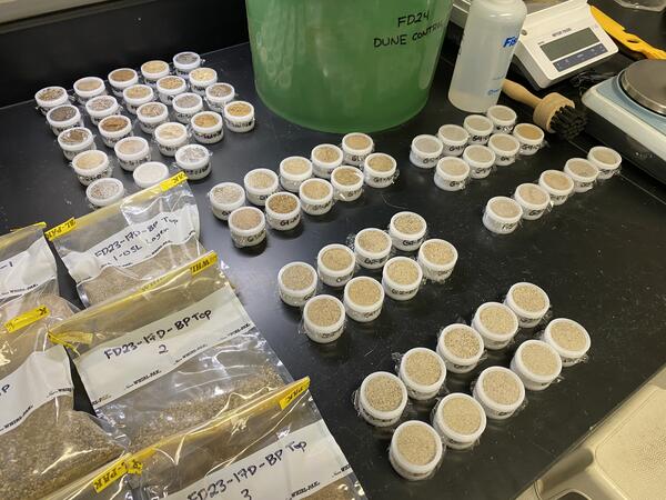
Sediment samples being prepared for portable X-ray fluorescence (XRF) analysis

A photo of sediment samples being prepared for portable X-ray fluorescence (XRF) analysis in the Laser Diffraction Lab at FBGC

Scientist wading in water next to the bank covered in leaves and a large fallen branch
USGS geologists document potential paleoliquefaction features from past seismicity at the southernmost edge of the Central Virginia Seismic Zone

USGS geologists document potential paleoliquefaction features from past seismicity at the southernmost edge of the Central Virginia Seismic Zone. Radiocarbon data suggest these features along Fountain Creek near Skippers, VA may be related to an earthquake that occurred near Petersburg, VA in the late 1700s.

Fountain Creek, Skippers, Virginia

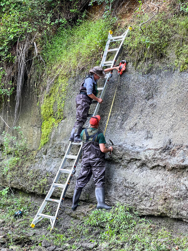
Brandon using tool to collect from sediment exposure
Brandon Graham collecting a sample from a sediment exposure at Army Base Fort Drum, New York

Brandon Graham collecting a sample from a sediment exposure at Army Base Fort Drum, New York. These samples were collected as part of an OSL (optically-stimulated luminescence) dating campaign in collaboration with Shannon Mahan of the USGS Luminescence Lab in Denver, CO.

Fall 2023 Photo Contest Winner: Grant Colip, USGS at Work category

Brandon Graham collecting a sample from a sediment exposure at Army Base Fort Drum, New York. These samples were collected as part of an OSL (optically-stimulated luminescence) dating campaign in collaboration with Shannon Mahan of the USGS Luminescence Lab in Denver, CO.

Fall 2023 Photo Contest Winner: Grant Colip, USGS at Work category

A woman standing in a stream holds a tape measure to a tree root.
Examining Tree Roots

Physical Scientist Molly Huber of the Florence Bascom Geoscience Center examines tree roots in a location where a root cookie was recently cut.

Molly was there as part of a stream habitat/riparian assessment at Orson Creek in south central Pennsylvania.

Physical Scientist Molly Huber of the Florence Bascom Geoscience Center examines tree roots in a location where a root cookie was recently cut.

Molly was there as part of a stream habitat/riparian assessment at Orson Creek in south central Pennsylvania.

excavated hole in forest with hydraulic piping equipment and muddy water
Gold mining site along the Cuyuni River, Guyana

Permitted small-scale gold mining site along the Cuyuni River in northwestern Guyana, June 2022. The picture depicts two gold mining hydraulic “dredges” in an excavated pit approximately 1 hectare in size. (Pete Chirico, USGS).

Permitted small-scale gold mining site along the Cuyuni River in northwestern Guyana, June 2022. The picture depicts two gold mining hydraulic “dredges” in an excavated pit approximately 1 hectare in size. (Pete Chirico, USGS).

Mapping the geology near historical graphite deposits on Lead Hill in Ticonderoga, New York

Mapping the geology near historical graphite deposits on Lead Hill in Ticonderoga, New York

Photo Contest Winner | Spring 2022 | Where We Work

map of Chesapeake Bay region showing study site locations
Map showing the location of the Atlantic Subsurface Stratigraphic Initiative study area in Maryland and Virginia.

Map showing the location of the study area in Maryland and Virginia.  Each dot represents an outcrop (red), core (black) or water well (orange) where Paleogene formation thicknesses were obtained.  The circular feature in the southern portion of the map is the Chesapeake Bay Impact Crater.  Paleogene sediments are not present in the crater.

Map showing the location of the study area in Maryland and Virginia.  Each dot represents an outcrop (red), core (black) or water well (orange) where Paleogene formation thicknesses were obtained.  The circular feature in the southern portion of the map is the Chesapeake Bay Impact Crater.  Paleogene sediments are not present in the crater.

two people standing outside taking notes
Geologists taking field notes

USGS Geologists Jean Self-Trail and Mercer Parker taking field notes, Prince George’s County

USGS Geologists Jean Self-Trail and Mercer Parker taking field notes, Prince George’s County

tan rock with numerous cm-scale shells and shell fragments
Paleocene gastropods and bivalve molluscs of the Aquia Formation

A densely packed shell bed of the Paleocene gastropods Kapalmerella mortonii and K. humerosa, along with various bivalve molluscs, King George County, Virginia

shells on black beach sand
Paleocene bivalve mollusc shells, Aquina Formation, Charles County, Maryland
geologist standing on rock outcrop near water
Indurated bed of the Paleocene Aquia Formation, Prince George’s County, Maryland

USGS Scientist Laurel Bybell standing on an indurated bed of the Paleocene Aquia Formation with a thick layer of highly fossilferous Aquia sediment above, Prince George’s County, Maryland

pick lying on a coarsening upward, fossil-rich outcrop
Aquia Formation (Paleocene) shell hash, Prince George’s County, Maryland

A typical Aquia Formation shell hash consisting mainly of the Paleocene gastropod Kapalmerella mortoni, Prince George’s County, Maryland

small waterfall over grey and tan rock, surrounded by greenery
Aquia Formation (Paleocene), Prince George’s County, Maryland
Paper mill reservoir in the Black River Valley

Photo Contest Winner | July 2021 | Where We Work
Paper mill reservoir in the Black River Valley, western Adirondacks, near Lyonsdale, New York

Photo Contest Winner | July 2021 | Where We Work
Paper mill reservoir in the Black River Valley, western Adirondacks, near Lyonsdale, New York

Jean Self-Trail and Laurel Bybell in Prince Georges County, Maryland

Photo Contest Winner | July 2021 | People
Jean Self-Trail and Laurel Bybell in Prince Georges County, Maryland

Four close-up images of a longer sediment core (bottom).
Hurricane deposits in a sediment core

Four close-up images of a longer sediment core (bottom). The light coloring indicates coarser sand that likely occurred from overwash flooding during a previous hurricane. This is one of a few cores collected in northwest Florida by the USGS and partners to help understand past hurricane activity in the Gulf of Mexico and northern Atlantic Ocean.

Four close-up images of a longer sediment core (bottom). The light coloring indicates coarser sand that likely occurred from overwash flooding during a previous hurricane. This is one of a few cores collected in northwest Florida by the USGS and partners to help understand past hurricane activity in the Gulf of Mexico and northern Atlantic Ocean.

Randy Orndorff examines limestone on Lake Champlain, VT

Photo Contest Winner | Nov. 2019 | USGS at Work
Randy Orndorff examines limestone on Lake Champlain, VT

Landslide at Howard Gap Road

Northeast Region Photo Contest Winner | June 2019 | USGS at Work
Landslide at Howard Gap Road, Hendersonville NC; People (R to L): Kelsey O'Pry, Corey Scheip, Jesse Hill, Jessica DeWitt; UAV imaging and geologic field observations are done to map the extent and activity of this landslide; Hendersonville, NC

Northeast Region Photo Contest Winner | June 2019 | USGS at Work
Landslide at Howard Gap Road, Hendersonville NC; People (R to L): Kelsey O'Pry, Corey Scheip, Jesse Hill, Jessica DeWitt; UAV imaging and geologic field observations are done to map the extent and activity of this landslide; Hendersonville, NC

Satellite imagery of eastern berm of Jim Foot Key in Florida Bay before and after Hurricane Irma.
Impacts to island in Florida Bay following Hurricane Irma, 2017

Scientists from the Florence Bascom Geoscience Center first sampled four islands in Florida Bay, Everglades National Park, in April 2014 to collect cores to study sea level rise and storm history in the region.  In September 2017, Hurricane Irma (a category 4 storm at landfall in the Florida Keys) passed just to the west of our field sites.  The western-mo

Scientists from the Florence Bascom Geoscience Center first sampled four islands in Florida Bay, Everglades National Park, in April 2014 to collect cores to study sea level rise and storm history in the region.  In September 2017, Hurricane Irma (a category 4 storm at landfall in the Florida Keys) passed just to the west of our field sites.  The western-mo

Was this page helpful?