
Sagebrush landscapes are prone to fire, which can increase the invasion of exotic annual grasses. Photo by Janey Prevéy (USGS)
Images
Here, you'll find images related to research going on at the Fort Collins Science Center. Our team of scientists are working on multiple areas of environmental interest, ranging from land conservation effectiveness to invasive reptiles.
Filter Total Items: 317

Sagebrush landscape
Sagebrush landscapes are prone to fire, which can increase the invasion of exotic annual grasses. Photo by Janey Prevéy (USGS)

Landscape view of encroaching invasive annual grasses
Landscape view of encroaching invasive annual grassesLandscape view of encroaching invasive annual grasses. Photo by Janet Prevéy (USGS).
Landscape view of encroaching invasive annual grasses
Landscape view of encroaching invasive annual grassesLandscape view of encroaching invasive annual grasses. Photo by Janet Prevéy (USGS).

Burned sagebrush habitat
Measuring annual grass abundance in a burned sagebrush plot. Photo by Janet Prevéy.
Measuring annual grass abundance in a burned sagebrush plot. Photo by Janet Prevéy.

Average abundance values within neighborhood clusters across the sage-grouse range over 6 low points
Average abundance values within neighborhood clusters across the sage-grouse range over 6 low pointsAverage abundance values within neighborhood clusters across the sage-grouse range over six low points.

Burros in Lake Pleasant HMA
Burros of the Lake Pleasant Herd Management Area, Arizona. Photo by K. Whyle (USGS).
Burros of the Lake Pleasant Herd Management Area, Arizona. Photo by K. Whyle (USGS).

Tricolored bat (Perimyotis subflavus) hanging in a cave
Tricolored bat (Perimyotis subflavus) hanging in a caveTricolored Bat hanging upside down in a cave. Photo by Andrea Schuhmann (USGS).
Tricolored bat (Perimyotis subflavus) hanging in a cave
Tricolored bat (Perimyotis subflavus) hanging in a caveTricolored Bat hanging upside down in a cave. Photo by Andrea Schuhmann (USGS).

PReSET Infographic
Process map of the application of the Prioritizing Restoration of Sagebrush Ecosystems Tool (PReSET) within the Wyoming Landscape Conservation Area.
Process map of the application of the Prioritizing Restoration of Sagebrush Ecosystems Tool (PReSET) within the Wyoming Landscape Conservation Area.

USGS researcher Janet Prevey deploys timelapse camera to capture cheatgrass phenology
USGS researcher Janet Prevey deploys timelapse camera to capture cheatgrass phenologyWe are deploying timelapse cameras across elevational and latitudinal gradients to capture variation in cheatgrass phenology.
USGS researcher Janet Prevey deploys timelapse camera to capture cheatgrass phenology
USGS researcher Janet Prevey deploys timelapse camera to capture cheatgrass phenologyWe are deploying timelapse cameras across elevational and latitudinal gradients to capture variation in cheatgrass phenology.

Invasive Annual Grasses
Field of invasive annual grasses. Photo by Janet Prevéy (USGS - Fort Collins Science Center).
Field of invasive annual grasses. Photo by Janet Prevéy (USGS - Fort Collins Science Center).

Tracking northwestern pond turtles at Fall Creek Reservoir
Tracking northwestern pond turtles at Fall Creek ReservoirUSGS scientist Nick Esser using radio telemetry to track northwestern pond turtles at Fall Creek Reservoir in Oregon. USGS researchers partner with the U.S. Army Corps of Engineers to study movement of turtles in response to fluctuating water levels.

Agua Fria National Monument Science Plan Kickoff Meeting - 2023
Agua Fria National Monument Science Plan Kickoff Meeting - 202311 individuals collaborating on potential science needs in preparation for drafting the Agua Fria National Monument Science Plan. This kickoff meeting occurred at the BLM field office on June 30, 2023.
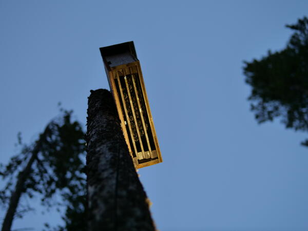
Bats roosting in a bat box
Bats roosting in a bat box during NABat Fieldwork in 2023.
Bats roosting in a bat box during NABat Fieldwork in 2023.
NABat scientists set up an acoustic detector
Photo Credit: Frankie Tousley
Photographed (from left to right): Rachel Shively, Joe Chabarek, and Andrea Schuhmann
Rachel, Joe, and Andrea set up an acoustic detector for a stationary point survey.
Photo Credit: Frankie Tousley
Photographed (from left to right): Rachel Shively, Joe Chabarek, and Andrea Schuhmann
Rachel, Joe, and Andrea set up an acoustic detector for a stationary point survey.
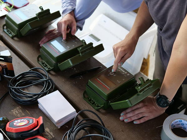
Wildlife Acoustic SM4BAT detectors used by the NABat team
Wildlife Acoustic SM4BAT detectors used by the NABat teamWildlife Acoustic SM4BAT detectors used by the NABat team. Photo Credit: Frankie Tousley
Wildlife Acoustic SM4BAT detectors used by the NABat team
Wildlife Acoustic SM4BAT detectors used by the NABat teamWildlife Acoustic SM4BAT detectors used by the NABat team. Photo Credit: Frankie Tousley
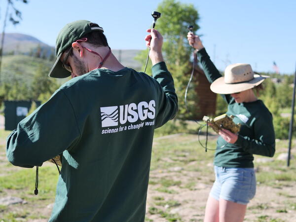
Testing acoustic microphones
Ben Lohre and Andrea Schuhmann test acoustic microphones prior to bat surveys, as part of the 2023 NABat field season.
Ben Lohre and Andrea Schuhmann test acoustic microphones prior to bat surveys, as part of the 2023 NABat field season.

Walking the shallows of Lake Abert, Oregon
Lake Abert, Oregon is one of the 20 terminal lakes identified by USGS partners as priority ecosystems for study by the Saline Lakes Ecosystems IWAA.
By
Ecosystems Mission Area, Water Resources Mission Area, Species Management Research Program, Water Availability and Use Science Program, Forest and Rangeland Ecosystem Science Center, Fort Collins Science Center, Nevada Water Science Center, Oregon Water Science Center, Utah Water Science Center, Western Ecological Research Center (WERC), Saline Lake Ecosystems Integrated Water Availability Assessment

Avocets flying above Farmington Bay Wildlife Management Area, Utah
Avocets flying above Farmington Bay Wildlife Management Area, UtahThe Saline Lake Ecosystems IWAA Waterbird Movement Project began tagging American Avocets in March 2023 to track their movements across the landscape. Tracking data from these birds will help scientists better understand why these birds choose to use the terminal lake and wetland habitats they do in the Great Basin.
By
Ecosystems Mission Area, Water Resources Mission Area, Species Management Research Program, Water Resources Research Act Program, Forest and Rangeland Ecosystem Science Center, Fort Collins Science Center, Nevada Water Science Center, Oregon Water Science Center, Utah Water Science Center, Western Ecological Research Center (WERC), Saline Lake Ecosystems Integrated Water Availability Assessment
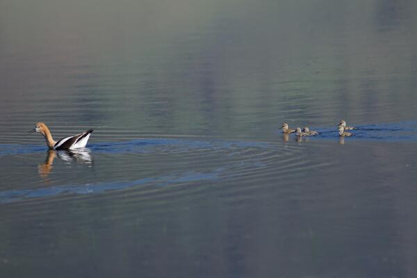
American Avocet trailed by chicks
American Avocet are a bird that relies heavily on the Saline Lakes ecosystem during their spring migration periods. Over 50% of these birds exist here. Part of their use includes using the terminal lakes there to breed.
By
Ecosystems Mission Area, Water Resources Mission Area, Species Management Research Program, Forest and Rangeland Ecosystem Science Center, Fort Collins Science Center, Nevada Water Science Center, Oregon Water Science Center, Utah Water Science Center, Western Ecological Research Center (WERC), Saline Lake Ecosystems Integrated Water Availability Assessment
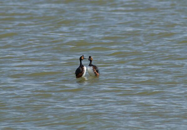
Eared grebes engaged in a courtship behavior
Eared grebes in a courtship behavior in the Great Salt Lake. They are one of many migratory birds in the Great Basin that rely on terminal lakes and wetlands in the area to stop rest and feed.
By
Ecosystems Mission Area, Water Resources Mission Area, Species Management Research Program, Forest and Rangeland Ecosystem Science Center, Fort Collins Science Center, Oregon Water Science Center, Utah Water Science Center, Western Ecological Research Center (WERC), Saline Lake Ecosystems Integrated Water Availability Assessment

Rapid Wildfire Risk Assessment: A Visual Guide
A visual guide to rapid wildfire risk assessment from the Wildfire Research Team (WiRē).
A visual guide to rapid wildfire risk assessment from the Wildfire Research Team (WiRē).

Sagebrush with and without cheatgrass
Sagebrush ecosystems with (top) and without (bottom) invasive annual grasses near Billings, MT (Photos: David Wood, USGS).
Sagebrush ecosystems with (top) and without (bottom) invasive annual grasses near Billings, MT (Photos: David Wood, USGS).