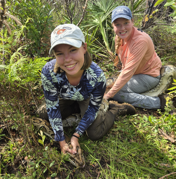
U.S. flag

An official website of the United States government

Images

Here, you'll find images related to research going on at the Fort Collins Science Center. Our team of scientists are working on multiple areas of environmental interest, ranging from land conservation effectiveness to invasive reptiles. 

Filter Total Items: 269
Microscopic view of tree rings, with a scale bar of 0.5 mm
Tree rings
Tree rings
Tree rings

Microscopic view of tree rings from a ponderosa pine in northern New Mexico. Photo by Ellis Margolis (USGS).

Microscopic view of tree rings from a ponderosa pine in northern New Mexico. Photo by Ellis Margolis (USGS).

a gloved hand holds four capped test tubes containing brown liquids, blue door in background
lignin phenol extracts from Great Dismal Swamp peats

Lignin phenol extracts from Great Dismal Swamp peats. Photo by Craig Stricker (USGS).

Lignin phenol extracts from Great Dismal Swamp peats. Photo by Craig Stricker (USGS).

a swampy wetland with dead tree trunks coming up from the water, cloudy skies
Great Dismal Swamp
Great Dismal Swamp
Great Dismal Swamp

The Great Dismal Swamp Wildlife Refuge spans Virginia and North Carolina. Photo by Craig Stricker (USGS). 

The Great Dismal Swamp Wildlife Refuge spans Virginia and North Carolina. Photo by Craig Stricker (USGS). 

a laboratory space containing technical equipment, drawers, desks, and chairs
Geology, Geophysics, and Geochemistry Stable Isotope Laboratory

Geology, Geophysics, and Geochemistry Stable Isotope Laboratory. Photo by Craig Stricker (USGS).

Geology, Geophysics, and Geochemistry Stable Isotope Laboratory. Photo by Craig Stricker (USGS).

a man in usgs coat stands in front of a grove of leafless cottonwood trees, snow on the ground around the trees
The Cottonwood Common Garden in 2025

Researchers, including Jonathan Friedman (pictured here) planted cottonwoods in this Common Garden plot in 2005, and since have monitored the growth and phenology of these trees. Every year since 2017, they cut back the trees to remove the confounding effect of age.

Researchers, including Jonathan Friedman (pictured here) planted cottonwoods in this Common Garden plot in 2005, and since have monitored the growth and phenology of these trees. Every year since 2017, they cut back the trees to remove the confounding effect of age.

two tan horses with dark legs and hair stand in a grassy landscape
Wild horses of the Conger Herd Management Area

Wild horses of the Conger Herd Management Area, Utah. Photo by Sarah King (Colorado State University).

Wild horses of the Conger Herd Management Area, Utah. Photo by Sarah King (Colorado State University).

twelve horses stand in front of a shrub-filled landscape, with mountains in the background
Wild horses of the Frisco HMA

Wild horses stand in sagebrush landscape in the Frisco Herd Management Area, Utah. Photo by E. Long.

Wild horses stand in sagebrush landscape in the Frisco Herd Management Area, Utah. Photo by E. Long.

five horses stand in a sagebrush landscape, with snow-capped mountains in the background
Wild horses of the Frisco HMA

Wild horses in a sagebrush landscape in the Frisco Herd Management Area, Utah. Photo by L. Prevot.

Wild horses in a sagebrush landscape in the Frisco Herd Management Area, Utah. Photo by L. Prevot.

three images, one showing flags in a river, one showing a man with instrument in a river, and another showing a plot
Green and Yampa River Data Collection

Working with the National Park Service Northern Colorado Plateau Network we are analyzing data from over 20 sites along the Green and Yampa rivers in Utah and Colorado, integrating annual data from thousands of 1-m2 plots, including plant species occurrence, surface elevation and percentage of time under water.

Working with the National Park Service Northern Colorado Plateau Network we are analyzing data from over 20 sites along the Green and Yampa rivers in Utah and Colorado, integrating annual data from thousands of 1-m2 plots, including plant species occurrence, surface elevation and percentage of time under water.

Scribbled writing in a journal entry on yellowish paper
Loch Vale Watershed Field Notebook Entry from 12/14/87

A field notebook entry from 12/14/87 from data collection and equipment maintenance for long term monitoring in the Loch Vale Watershed, Rocky Mountain National Park. Screenshot taken from FieldBook19871006_19891031_p1 from https://doi.org/10.5066/P1CXWAVP

A field notebook entry from 12/14/87 from data collection and equipment maintenance for long term monitoring in the Loch Vale Watershed, Rocky Mountain National Park. Screenshot taken from FieldBook19871006_19891031_p1 from https://doi.org/10.5066/P1CXWAVP

field notebook data on worn paper
Loch Vale Watershed Field Notebook Entry from 8/29/19

A field notebook entry from 8/29/19 from data collection and equipment maintenance for long term monitoring in the Loch Vale Watershed, Rocky Mountain National Park. Screenshot taken from FieldBook20190819_20201208_p1 from https://doi.org/10.5066/P1CXWAVP

A field notebook entry from 8/29/19 from data collection and equipment maintenance for long term monitoring in the Loch Vale Watershed, Rocky Mountain National Park. Screenshot taken from FieldBook20190819_20201208_p1 from https://doi.org/10.5066/P1CXWAVP

field data notes on lined scratch paper
Loch Vale Watershed Field Notebook Entry from 3/2/10

A field notebook entry from 3/2/10 from data collection and equipment maintenance for long term monitoring in the Loch Vale Watershed, Rocky Mountain National Park. Screenshot taken from FieldBook20100112_20100413 from https://doi.org/10.5066/P1CXWAVP

Entry Text:

A field notebook entry from 3/2/10 from data collection and equipment maintenance for long term monitoring in the Loch Vale Watershed, Rocky Mountain National Park. Screenshot taken from FieldBook20100112_20100413 from https://doi.org/10.5066/P1CXWAVP

Entry Text:

scribbled notes on worn paper
Loch Vale Watershed Field Notebook Entry from 3/25/97

A field notebook entry from 3/25/97 from data collection and equipment maintenance for long term monitoring in the Loch Vale Watershed, Rocky Mountain National Park. Screenshot taken from FieldBook19960507_20060627_p2 from https://doi.org/10.5066/P1CXWAVP

Entry text: 1st day of 1997 sampling

A field notebook entry from 3/25/97 from data collection and equipment maintenance for long term monitoring in the Loch Vale Watershed, Rocky Mountain National Park. Screenshot taken from FieldBook19960507_20060627_p2 from https://doi.org/10.5066/P1CXWAVP

Entry text: 1st day of 1997 sampling

map of rocky mountain national park and the loch vale watershed with a key describing features
Long-term monitoring sites in the Loch Vale Watershed

A map of the locations of all sample sites within Loch Vale and additional long-term sites in Rocky Mountain National Park is included with the field notebook files. From: 

A map of the locations of all sample sites within Loch Vale and additional long-term sites in Rocky Mountain National Park is included with the field notebook files. From: 

flat, bushy landscape with partly cloudy sunset above
Sagebrush in Seedskadee National Wildlife Refuge

A sea of sagebrush in Seedskadee National Wildlife Refuge. Photo by Emma Dietrich (USGS).

A sea of sagebrush in Seedskadee National Wildlife Refuge. Photo by Emma Dietrich (USGS).

mountains jut into a partly cloudy ski. Shrubs and succulents in the foreground.
Red Rock Canyon National Conservation Area

The spectacular Mojave Desert landscapes within Red Rock Canyon National Conservation area draw millions of visitors each year. 

The spectacular Mojave Desert landscapes within Red Rock Canyon National Conservation area draw millions of visitors each year. 

red mountains against a blue sky, shrubs in front
Red Rock Canyon National Conservation Area

The spectacular Mojave Desert landscapes within Red Rock Canyon National Conservation area draw millions of visitors each year. 

The spectacular Mojave Desert landscapes within Red Rock Canyon National Conservation area draw millions of visitors each year. 

layers of exposed rock with a car track and buildings at bottom of photo
Cotoni-Coast Dairies Retired Mine

For most of the 1900s, sections of the Cotoni-Coast Dairies unit of the California Coast National Monument were mined for limestone and shale. Minerals were transported to the cement plant from the top of quarries through conveyer belts like this one.

For most of the 1900s, sections of the Cotoni-Coast Dairies unit of the California Coast National Monument were mined for limestone and shale. Minerals were transported to the cement plant from the top of quarries through conveyer belts like this one.

a hilly landscape with degraded forest and grasses, trees and blue sky in the background
Hillsides invaded by nonnative plants in Cotoni Coast Dairies

Hillside of the Cotoni Coast Dairies onshore unit of the California Coastal National Monument. Prior to becoming a monument, parts of the landscape like those seen here degraded as a result of human development and invasive species. Monument managers are now looking to incorporate the best available science into their restoration plans.

Hillside of the Cotoni Coast Dairies onshore unit of the California Coastal National Monument. Prior to becoming a monument, parts of the landscape like those seen here degraded as a result of human development and invasive species. Monument managers are now looking to incorporate the best available science into their restoration plans.

view of shrubs leading into the ocean, blue skys
View of the Pacific Ocean from Cotoni Coast Dairies

View of the Pacific Ocean from the Cotoni-Coast Dairies unit of the California Coast National Monument.

View of the Pacific Ocean from the Cotoni-Coast Dairies unit of the California Coast National Monument.

Was this page helpful?