
Fisher Mesa as viewed from the west slopes of the La Sal Mountains, UT. Photo by Andreas Wion (USGS).
Images
Here, you'll find images related to research going on at the Fort Collins Science Center. Our team of scientists are working on multiple areas of environmental interest, ranging from land conservation effectiveness to invasive reptiles.
Filter Total Items: 317

Fisher Mesa
Fisher Mesa as viewed from the west slopes of the La Sal Mountains, UT. Photo by Andreas Wion (USGS).

Post-Fire Landscape
Snag fall after the 2011 Las Conchas Fire, which burned over 150,000 acres in New Mexico.
Snag fall after the 2011 Las Conchas Fire, which burned over 150,000 acres in New Mexico.

Field intern prepares to sample fire-scarred stump near the Mogollon Rim in Arizona
Field intern prepares to sample fire-scarred stump near the Mogollon Rim in ArizonaField intern prepares to sample fire-scarred stump near the Mogollon Rim in Arizona. Photo by Melanie Wright (USGS).
Field intern prepares to sample fire-scarred stump near the Mogollon Rim in Arizona
Field intern prepares to sample fire-scarred stump near the Mogollon Rim in ArizonaField intern prepares to sample fire-scarred stump near the Mogollon Rim in Arizona. Photo by Melanie Wright (USGS).
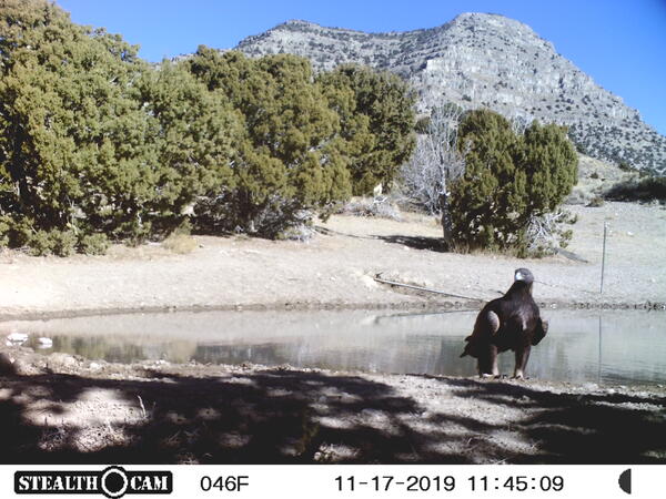
Golden eagle sits next to a pond in photo captured by a trail camera - cloned
Golden eagle sits next to a pond in photo captured by a trail camera - clonedGolden eagle next to pond, captured by a trail camera next to a pond in the Conger Herd Management Area, Utah.
Golden eagle sits next to a pond in photo captured by a trail camera - cloned
Golden eagle sits next to a pond in photo captured by a trail camera - clonedGolden eagle next to pond, captured by a trail camera next to a pond in the Conger Herd Management Area, Utah.

Setting up NABat stationary monitoring
Setting up NABat stationary monitoring
Photo Credit: Paul Cryan, USGS
Setting up NABat stationary monitoring | Photo Credit: Paul … | Flickr
Setting up NABat stationary monitoring
Photo Credit: Paul Cryan, USGS
Setting up NABat stationary monitoring | Photo Credit: Paul … | Flickr
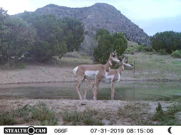
Pronghorn captured by a trail camera
Pronghorn captured by a trail camera next to a pond in the Conger Herd Management Area, Utah.
Pronghorn captured by a trail camera next to a pond in the Conger Herd Management Area, Utah.
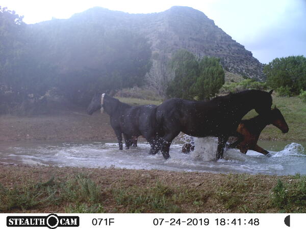
Wild horses bathing in a pond in photo captured by a trail camera
Wild horses bathing in a pond in photo captured by a trail cameraWild horses bath in a pond, captured by a trail camera next to a pond in the Conger Herd Management Area, Utah.
Wild horses bathing in a pond in photo captured by a trail camera
Wild horses bathing in a pond in photo captured by a trail cameraWild horses bath in a pond, captured by a trail camera next to a pond in the Conger Herd Management Area, Utah.
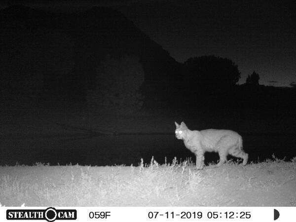
Bobcat photo captured by a trail camera
Bobcat captured by a trail camera next to a pond in the Conger Herd Management Area, Utah.
Bobcat captured by a trail camera next to a pond in the Conger Herd Management Area, Utah.

Mule deer crossing road
NPS image by Adams. A mule deer stands at the side of a road at Grand Teton National Park.
NPS image by Adams. A mule deer stands at the side of a road at Grand Teton National Park.
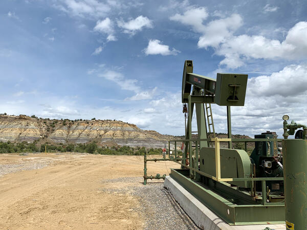
A pumpjack on an active oil or gas drilling site in New Mexico
A pumpjack on an active oil or gas drilling site in New MexicoA pumpjack on an active oil or gas drilling site near Farmington, New Mexico. Photo by Mike Duniway, USGS, SBSC.
A pumpjack on an active oil or gas drilling site in New Mexico
A pumpjack on an active oil or gas drilling site in New MexicoA pumpjack on an active oil or gas drilling site near Farmington, New Mexico. Photo by Mike Duniway, USGS, SBSC.

Fire scar sample
Tree-ring fire scars from a ponderosa pine in northern New Mexico. The years indicate the year the tree burned and scarred, and the letters indicate the position of the fire scar in the tree ring (D = spring dormant and EE = early earlywood). Photo by Ellis Margolis (USGS)
Tree-ring fire scars from a ponderosa pine in northern New Mexico. The years indicate the year the tree burned and scarred, and the letters indicate the position of the fire scar in the tree ring (D = spring dormant and EE = early earlywood). Photo by Ellis Margolis (USGS)

Tree rings
Microscopic view of tree rings from a ponderosa pine in northern New Mexico. Photo by Ellis Margolis (USGS).
Microscopic view of tree rings from a ponderosa pine in northern New Mexico. Photo by Ellis Margolis (USGS).

Wind_turbines_thermal_cams_UV_lights_P_Cryan.JPG
Bat, bird, and insect activity can be monitored with pairs of thermal-imaging cameras mounted on the wind turbines, and automatically recorded to a computer inside the base of the turbine.
Bat, bird, and insect activity can be monitored with pairs of thermal-imaging cameras mounted on the wind turbines, and automatically recorded to a computer inside the base of the turbine.

Big sagebrush with rainbow in southeast Oregon
Big sagebrush with rainbow at the SageSTEP project Five Creeks study site north of Steens Mountain in southeast Oregon. Photo by Steve Hanser (USGS).
Big sagebrush with rainbow at the SageSTEP project Five Creeks study site north of Steens Mountain in southeast Oregon. Photo by Steve Hanser (USGS).
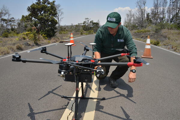
USGS scientist setting up an uncrewed aircraft system (UAS)
USGS scientist setting up an uncrewed aircraft system (UAS)FORT scientist Chris Holmquist-Johnson leverages uncrewed aircraft systems (UAS), such as the one shown here, to advance hydrological research through innovative aerial data collection. As a certified UAS Instructor for the Department of the Interior (DOI), he also leads training programs to expand UAS capabilities among DOI scientists.

Using telemetry to track movement, habitat use and dispersal of frogs
Using telemetry to track movement, habitat use and dispersal of frogsUsing telemetry to track movement, habitat use and dispersal of frogs in an Iowa wetland.
Using telemetry to track movement, habitat use and dispersal of frogs
Using telemetry to track movement, habitat use and dispersal of frogsUsing telemetry to track movement, habitat use and dispersal of frogs in an Iowa wetland.

Blue Vane trap in Conservation Reserve Program (CRP) field
Blue Vane trap in Conservation Reserve Program (CRP) fieldBlue Vane trap in Conservation Reserve Program (CRP) field
Blue Vane trap in Conservation Reserve Program (CRP) field
Blue Vane trap in Conservation Reserve Program (CRP) fieldBlue Vane trap in Conservation Reserve Program (CRP) field

Select CRP fields for on-site assessments
This map shows the distribution of select Conservation Reserve Program (CRP) fields for on-site assessments.
This map shows the distribution of select Conservation Reserve Program (CRP) fields for on-site assessments.

Native sunflowers in a Kansas Conservation Reserve Program (CRP) field
Native sunflowers in a Kansas Conservation Reserve Program (CRP) fieldNative sunflowers in a Kansas Conservation Reserve Program (CRP) field
Native sunflowers in a Kansas Conservation Reserve Program (CRP) field
Native sunflowers in a Kansas Conservation Reserve Program (CRP) fieldNative sunflowers in a Kansas Conservation Reserve Program (CRP) field

Recently plowed crop field in Kansas suffering from wind erosion
Recently plowed crop field in Kansas suffering from wind erosionAbandoned center-pivot irrigated cropland results in destabilized sandy soils that are badly eroded by wind. An example of a recently plowed field in Kansas.
Recently plowed crop field in Kansas suffering from wind erosion
Recently plowed crop field in Kansas suffering from wind erosionAbandoned center-pivot irrigated cropland results in destabilized sandy soils that are badly eroded by wind. An example of a recently plowed field in Kansas.

USDA Conservation Reserve Program (CRP) field planted for pollinators
USDA Conservation Reserve Program (CRP) field planted for pollinatorsUSDA Conservation Reserve Program (CRP) field planted for pollinators
USDA Conservation Reserve Program (CRP) field planted for pollinators
USDA Conservation Reserve Program (CRP) field planted for pollinatorsUSDA Conservation Reserve Program (CRP) field planted for pollinators