UAS in flight at the Alamosa National Wildlife Refuge in Colorado
UAS in flight at the Alamosa National Wildlife Refuge in ColoradoUAS in flight at the Alamosa National Wildlife Refuge in Colorado

Official websites use .gov
A .gov website belongs to an official government organization in the United States.
Secure .gov websites use HTTPS
A lock () or https:// means you’ve safely connected to the .gov website. Share sensitive information only on official, secure websites.

UAS in flight at the Alamosa National Wildlife Refuge in Colorado
UAS in flight at the Alamosa National Wildlife Refuge in Colorado

Boardwalk through the Bonanza Creek Long-Term Ecological Research Site near Fairbanks, Alaska
In August 2023 the NUSO flew UAS equipped with custom methane-detecting sensors over Interior Alaska to support USGS and U.S. Environmental Protection Agency (EPA) Office of Research and Development research into low-cost ways to measure methane emissions.

USGS researcher Joe Adams preparing a UAS for flight at the Bonanza Creek Long-Term Ecological Research Site in Alaska
USGS researcher Joe Adams preparing a UAS for flight at the Bonanza Creek Long-Term Ecological Research Site in Alaska

Matt Burgess (NUSO) providing shade to remote pilot Victoria Scholl (NUSO) as she flies a UAS over crops in California
Matt Burgess (NUSO) providing shade to remote pilot Victoria Scholl (NUSO) as she flies a UAS over crops in California

Collaborators Kristen Manies (Geology, Minerals, Energy, and Geophysics Science Center), Joe Adams (National Uncrewed Systems Office, NUSO), Victoria Scholl (NUSO), Brian Gullett U.S.
Collaborators Kristen Manies (Geology, Minerals, Energy, and Geophysics Science Center), Joe Adams (National Uncrewed Systems Office, NUSO), Victoria Scholl (NUSO), Brian Gullett U.S.

Physical Scientist Michelle Leung prepares to drill tree cores in the southern Sangre de Cristo Mountains, Colorado. Tree cores provide seasonal to centennial records of past precipitation and provide local to regional reconstructions of hydroclimate.
Physical Scientist Michelle Leung prepares to drill tree cores in the southern Sangre de Cristo Mountains, Colorado. Tree cores provide seasonal to centennial records of past precipitation and provide local to regional reconstructions of hydroclimate.

Michelle Leung and Becky Brice collect samples from fire-scarred trees in the southern Sangre de Cristo Mountains, Colorado. Trees provide records of past droughts, fires, and the response of vegetation to a changing snowpack.
Michelle Leung and Becky Brice collect samples from fire-scarred trees in the southern Sangre de Cristo Mountains, Colorado. Trees provide records of past droughts, fires, and the response of vegetation to a changing snowpack.

Physical Scientist Michelle Leung and Geographer Becky Brice collect samples from fire-scarred trees in the southern Sangre de Cristo Mountains, Colorado. Trees provide records of past droughts, fires, and the response of vegetation to a changing snowpack.
Physical Scientist Michelle Leung and Geographer Becky Brice collect samples from fire-scarred trees in the southern Sangre de Cristo Mountains, Colorado. Trees provide records of past droughts, fires, and the response of vegetation to a changing snowpack.
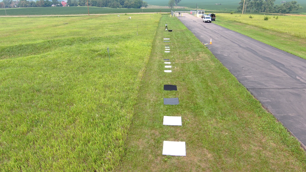
Drone-captured photo of reference targets with various materials and reflectance levels used during a field campaign in support of radiometric calibration research led by USGS Earth Resources Observation and Science (EROS) researchers in Sioux Falls, South Dakota.
Drone-captured photo of reference targets with various materials and reflectance levels used during a field campaign in support of radiometric calibration research led by USGS Earth Resources Observation and Science (EROS) researchers in Sioux Falls, South Dakota.

USGS ECCOE and NUSO personnel at the UAS ground control station discussing flight parameters for the day’s drone flights near EROS
Left to Right:
Back Row -- Mahesh Shrestha (ECCOE), Tom Cecere (NLI HQ), Jeff Irwin (ECCOE), Joe Adams (NUSO)
Front Row -- Matt Burgess (NUSO), Victoria Scholl (NUSO)
USGS ECCOE and NUSO personnel at the UAS ground control station discussing flight parameters for the day’s drone flights near EROS
Left to Right:
Back Row -- Mahesh Shrestha (ECCOE), Tom Cecere (NLI HQ), Jeff Irwin (ECCOE), Joe Adams (NUSO)
Front Row -- Matt Burgess (NUSO), Victoria Scholl (NUSO)

USGS NUSO scientists Matt Burgess and Victoria Scholl check the hyperspectral sensor mounted on a UAS prior to flight in South Dakota
USGS NUSO scientists Matt Burgess and Victoria Scholl check the hyperspectral sensor mounted on a UAS prior to flight in South Dakota

USGS researchers Lance Brady and Joe Adams (NUSO) calibrate the compass of an AgEagle/MicaSense multispectral payload mounted on a UAS prior to a flight in South Dakota. This involves lifting and rotating the aircraft in specific sequences as indicated on the connected tablet.
USGS researchers Lance Brady and Joe Adams (NUSO) calibrate the compass of an AgEagle/MicaSense multispectral payload mounted on a UAS prior to a flight in South Dakota. This involves lifting and rotating the aircraft in specific sequences as indicated on the connected tablet.

A freshly opened lake core from Alaska with continuous sediment layers that get older from the top of the core to the bottom.
A freshly opened lake core from Alaska with continuous sediment layers that get older from the top of the core to the bottom.

NUSO remote pilot Mark Bauer getting ready to launch a UAS at Ackerson Meadow in California
NUSO remote pilot Mark Bauer getting ready to launch a UAS at Ackerson Meadow in California

Bridge over the Green Mountain Reservoir used as a test site for UAS infrastructure inspections
The NUSO, along with U.S. Bureau of Reclamation participated in a June 2023 test and evaluation of an uncrewed aircraft’s 3D scan capability for assisting with infrastructure inspections near Heeney, Colorado at the Green Mountain Reservoir.

The NUSO, along with U.S. Bureau of Reclamation participated in a June 2023 test and evaluation of an uncrewed aircraft’s 3D scan capability for assisting with infrastructure inspections near Heeney, Colorado at the Green Mountain Reservoir.
The NUSO, along with U.S. Bureau of Reclamation participated in a June 2023 test and evaluation of an uncrewed aircraft’s 3D scan capability for assisting with infrastructure inspections near Heeney, Colorado at the Green Mountain Reservoir.

Mark Bauer (USGS NUSO) observing a UAS in flight at California's Ackerson Meadow controlled by remote pilot Victoria Scholl (USGS NUSO)
Mark Bauer (USGS NUSO) observing a UAS in flight at California's Ackerson Meadow controlled by remote pilot Victoria Scholl (USGS NUSO)

USGS NUSO scientist Mark Bauer measuring the height of a GNSS receiver secured onto a survey tripod during a UAS mission in California
USGS NUSO scientist Mark Bauer measuring the height of a GNSS receiver secured onto a survey tripod during a UAS mission in California

USGS remote pilot Todd Burton flying a UAS at a bridge over the Green Mountain Reservoir
The NUSO, along with U.S. Bureau of Reclamation participated in a June 2023 test and evaluation of an uncrewed aircraft’s 3D scan capability for assisting with infrastructure inspections near Heeney, Colorado at the Green Mountain Reservoir.

UAS mounted with a lidar sensor in flight at the Ackerson Meadow in California
UAS mounted with a lidar sensor in flight at the Ackerson Meadow in California

UAS operations near Moab, Utah for carbon sequestration research on public lands
UAS operations near Moab, Utah for carbon sequestration research on public lands