
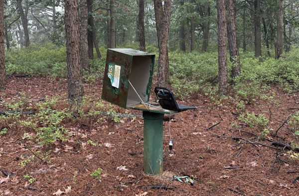
A field computer connected to the water level probe in the Tom's River 84 Obs well to download the data collected since the last inspection.
Images
Images intro.
Filter Total Items: 291
Toms River Groundwater
A field computer connected to the water level probe in the Tom's River 84 Obs well to download the data collected since the last inspection.

Pennsylvania state-wide surface water PFAS study
This map shows 161 sites across Pennsylvania that were sampled for PFAS concentrations. The color coding indicates PFAS concentration levels at each site. USGS image.
This map shows 161 sites across Pennsylvania that were sampled for PFAS concentrations. The color coding indicates PFAS concentration levels at each site. USGS image.

Sampler_Platform_2
Floating platform deployment for the automatic bacteria analyzer, facing downstream, at Passaic River below Pompton River at Two Bridges, New Jersey.
Floating platform deployment for the automatic bacteria analyzer, facing downstream, at Passaic River below Pompton River at Two Bridges, New Jersey.

Sampler Power
Hydrographer Dan Skulski replaces the battery of the automatic bacteria analyzer.
Hydrographer Dan Skulski replaces the battery of the automatic bacteria analyzer.

Sampler Platform
Floating sampling platform deployment for the automatic bacteria analyzer,facing upstream, at Passaic River below Pompton River at Two Bridges, New Jersey.
Floating sampling platform deployment for the automatic bacteria analyzer,facing upstream, at Passaic River below Pompton River at Two Bridges, New Jersey.

Cleaning the Sampler
Hydrographer Dan Skulski cleans the device of fouling prior to changing out the sample cartriges.
Hydrographer Dan Skulski cleans the device of fouling prior to changing out the sample cartriges.

Sampler_Platform 3
Field readings are being collected using a water-quality multimeter prior to initiating a sample from the bacteria analyzer.
Field readings are being collected using a water-quality multimeter prior to initiating a sample from the bacteria analyzer.

Setting the sampler
Hydrographer Jake Gray removes the automatic bacteria analyzer to perform regular servicing.
Hydrographer Jake Gray removes the automatic bacteria analyzer to perform regular servicing.

Lodi n-value
Crest Stage Gage attached to tree near the bridge near 01391500 Saddle River at Lodi, New Jersey for part of the n-value Study.
Crest Stage Gage attached to tree near the bridge near 01391500 Saddle River at Lodi, New Jersey for part of the n-value Study.

Blue_Mussels
Scientists Kathryn Cahalane and Lucas Sirotniak sort blue mussels (Mytilus edulis) from the Atlantic Ocean for the analysis of cyanotoxins in mussel tissue.
Scientists Kathryn Cahalane and Lucas Sirotniak sort blue mussels (Mytilus edulis) from the Atlantic Ocean for the analysis of cyanotoxins in mussel tissue.

Hatchery Brook 1
Trail camera image used for monitoring stream flow, looking upstream towards a culvert along 01456100 Hatchery Brook at Hackettstown, New Jersey. Many cameras have been placed in urban streams to better understand the changing conditions.
Trail camera image used for monitoring stream flow, looking upstream towards a culvert along 01456100 Hatchery Brook at Hackettstown, New Jersey. Many cameras have been placed in urban streams to better understand the changing conditions.

Troutbrook Cam and sensor
USGS Trail Camera and air Tidbit temperature shelter attached to a tree looking facing downstream on Trout Brook at Grand Ave near Hackettstown, New Jersey. Having both sensors allows for quick identification of on-site conditions during temperature anomalies.
USGS Trail Camera and air Tidbit temperature shelter attached to a tree looking facing downstream on Trout Brook at Grand Ave near Hackettstown, New Jersey. Having both sensors allows for quick identification of on-site conditions during temperature anomalies.

Two-Bridges Gage
The automatic bacteria analyzer is positioned in line with the continuous water quality monitor onsite, allowing for the simultaneous collection of field readings during automatic bacteria analyzer samples.
The automatic bacteria analyzer is positioned in line with the continuous water quality monitor onsite, allowing for the simultaneous collection of field readings during automatic bacteria analyzer samples.

Toms River n-value
USGS Scientist Michal Niemoczynski is setting up a level transit to conduct a survey of the streambed cross-section at the 01408500 Toms River at Tom’s River, New Jersey.
USGS Scientist Michal Niemoczynski is setting up a level transit to conduct a survey of the streambed cross-section at the 01408500 Toms River at Tom’s River, New Jersey.

JBMDL Particles
Model particle tracking end point results, Joint Base McGuire-Dix-Lakehurst, New Jersey.
Model particle tracking end point results, Joint Base McGuire-Dix-Lakehurst, New Jersey.
Elizabeth River
USGS 01393450 Elizabeth River at Ursino Lake at Elizabeth New Jersey looking upstream from the gage along the riverbed.
USGS 01393450 Elizabeth River at Ursino Lake at Elizabeth New Jersey looking upstream from the gage along the riverbed.

Ducks at Strykers Road
Trail camera image on Lopcatcong Creek in New Jersey. Although not a primary function of the project and model, Flow Photo Explorer flags images containing animals for the user. Here on a chilly day, several mallard ducks were photographed.
Trail camera image on Lopcatcong Creek in New Jersey. Although not a primary function of the project and model, Flow Photo Explorer flags images containing animals for the user. Here on a chilly day, several mallard ducks were photographed.

Folsom n-value
A calibrate tape strung across the river at 01411000 Great Egg Harbor River at Folsom, New Jersey as part of the cross-section profile for the study.
A calibrate tape strung across the river at 01411000 Great Egg Harbor River at Folsom, New Jersey as part of the cross-section profile for the study.

PFAS in Select U.S. Tapwater Locations
This USGS map shows the number of PFAS detected in tap water samples from select sites across the nation. The findings are based on a USGS study of samples taken between 2016 and 2021 from private and public supplies at 716 locations. The map does not represent the only locations in the U.S. with PFAS.
This USGS map shows the number of PFAS detected in tap water samples from select sites across the nation. The findings are based on a USGS study of samples taken between 2016 and 2021 from private and public supplies at 716 locations. The map does not represent the only locations in the U.S. with PFAS.

Squankum n-value
Looking upstream from the farthest n-value CSG at 01408000 Manasquan River at Squankum, New Jersey
Looking upstream from the farthest n-value CSG at 01408000 Manasquan River at Squankum, New Jersey

Setting up for sampling
USGS Scientist Lucas Sirotniak visually inspects the SPATTs that are attached to a post and retrieved from Deal Lake, NJ.
USGS Scientist Lucas Sirotniak visually inspects the SPATTs that are attached to a post and retrieved from Deal Lake, NJ.