
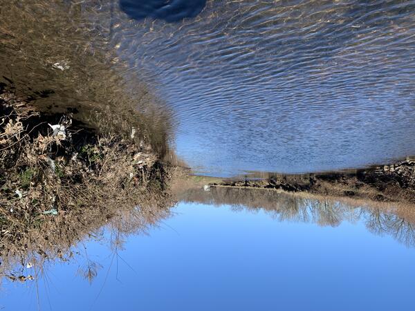
USGS 01393450 Elizabeth River at Ursino Lake at Elizabeth New Jersey looking upstream from the gage along the riverbed.
Images
Images intro.
Filter Total Items: 297
Elizabeth River
USGS 01393450 Elizabeth River at Ursino Lake at Elizabeth New Jersey looking upstream from the gage along the riverbed.

Ducks at Strykers Road
Trail camera image on Lopcatcong Creek in New Jersey. Although not a primary function of the project and model, Flow Photo Explorer flags images containing animals for the user. Here on a chilly day, several mallard ducks were photographed.
Trail camera image on Lopcatcong Creek in New Jersey. Although not a primary function of the project and model, Flow Photo Explorer flags images containing animals for the user. Here on a chilly day, several mallard ducks were photographed.

Folsom n-value
A calibrated tape strung across the river at 01411000 Great Egg Harbor River at Folsom, New Jersey, as part of the cross-section profile for the study.
A calibrated tape strung across the river at 01411000 Great Egg Harbor River at Folsom, New Jersey, as part of the cross-section profile for the study.

PFAS in Select U.S. Tapwater Locations
This USGS map shows the number of PFAS detected in tap water samples from select sites across the nation. The findings are based on a USGS study of samples taken between 2016 and 2021 from private and public supplies at 716 locations. The map does not represent the only locations in the U.S. with PFAS.
This USGS map shows the number of PFAS detected in tap water samples from select sites across the nation. The findings are based on a USGS study of samples taken between 2016 and 2021 from private and public supplies at 716 locations. The map does not represent the only locations in the U.S. with PFAS.

Squankum n-value
Looking upstream from the farthest n-value CSG at 01408000 Manasquan River at Squankum, New Jersey
Looking upstream from the farthest n-value CSG at 01408000 Manasquan River at Squankum, New Jersey

Setting up for sampling
USGS Scientist Lucas Sirotniak visually inspects the SPATTs that are attached to a post and retrieved from Deal Lake, NJ.
USGS Scientist Lucas Sirotniak visually inspects the SPATTs that are attached to a post and retrieved from Deal Lake, NJ.

Sampling Rocks
USGS scientists climb on boulders of the jetty at Asbury Park to collect blue mussels (Mytilus edulis) and biological measurements from the Atlantic Ocean for analysis of cyanotoxins in mussel tissue.
USGS scientists climb on boulders of the jetty at Asbury Park to collect blue mussels (Mytilus edulis) and biological measurements from the Atlantic Ocean for analysis of cyanotoxins in mussel tissue.

Sample run
Scientists Brad Bjorklund and Erika Bernal prepare to deploy continuous water-quality sensors at Deal Lake, NJ.
Scientists Brad Bjorklund and Erika Bernal prepare to deploy continuous water-quality sensors at Deal Lake, NJ.

Ocean Sample Collection
USGS scientists climb on boulders of the jetty to collect blue mussels (Mytilus edulis) from the surf of the Atlantic Ocean.
USGS scientists climb on boulders of the jetty to collect blue mussels (Mytilus edulis) from the surf of the Atlantic Ocean.

NJ HABs Team
Team of USGS scientists collect blue mussels (Mytilus edulis) and biological measurements from the Atlantic Ocean for analysis of cyanotoxins in mussel tissue.
Team of USGS scientists collect blue mussels (Mytilus edulis) and biological measurements from the Atlantic Ocean for analysis of cyanotoxins in mussel tissue.

Study Basin Map
The map overview highlights the three basins involved in the monitoring project across southern New Jersey. The USGS gages listed are the nearest telemetry stations recording tidal elevation, specific conductance, and water temperature.
The map overview highlights the three basins involved in the monitoring project across southern New Jersey. The USGS gages listed are the nearest telemetry stations recording tidal elevation, specific conductance, and water temperature.

Maurice River Cross Sections
An example of a Maurice River longitudinal profile survey on 6/30/2022. The average specific conductivity is shown at each cross-section. The transects help demonstrate the relationship between specific conductivity and distance upstream from the mouth of the Maurice River.
An example of a Maurice River longitudinal profile survey on 6/30/2022. The average specific conductivity is shown at each cross-section. The transects help demonstrate the relationship between specific conductivity and distance upstream from the mouth of the Maurice River.

Belelville n-Value
Looking upstream along the channel at the n-value cross-sections at 01392500 Second River at Belleville, New Jersey
Looking upstream along the channel at the n-value cross-sections at 01392500 Second River at Belleville, New Jersey

Margate Webcam
Webcam overlooking slips along the Margate Bay at the Beach Thorofare at Margate, New Jersey
Webcam overlooking slips along the Margate Bay at the Beach Thorofare at Margate, New Jersey

Atlantic City Webcam
Looking out on Atlantic City from the 01410560 Inside Thorofare at Atlantic City, New jersey gage
Looking out on Atlantic City from the 01410560 Inside Thorofare at Atlantic City, New jersey gage

Mountainview Webcam
Webcam view looking downstream along the Pompton Rover at Mountainview, New Jersey.
Webcam view looking downstream along the Pompton Rover at Mountainview, New Jersey.

Sea Isle Webcam
New Jersey gage webcam looking out along the river community near 01411350 Ludlam Thorofare at Sea Isle City, New Jersey
New Jersey gage webcam looking out along the river community near 01411350 Ludlam Thorofare at Sea Isle City, New Jersey

Rockaway Webcam
Rockaway River flowing over the weir at 01380450 Rockaway River at Main St. at Boonton, New Jersey.
Rockaway River flowing over the weir at 01380450 Rockaway River at Main St. at Boonton, New Jersey.

Belvidere Webcam
View from the top of the embankment looking down the stairs to the Delaware River below 01446500 Delaware River at Belvidere, New Jersey
View from the top of the embankment looking down the stairs to the Delaware River below 01446500 Delaware River at Belvidere, New Jersey

Pompton Lakes Webcam
Webcam image of the control constricting the flow of the Ramapo River at Pompton Lakes, New Jersey
Webcam image of the control constricting the flow of the Ramapo River at Pompton Lakes, New Jersey

Alloway Creek Survey
Alloway Creek during a recon survey heading upstream from the Quinton boat launch and downstream of the Route 540 Bridge.
Alloway Creek during a recon survey heading upstream from the Quinton boat launch and downstream of the Route 540 Bridge.