
Flooding in New Jersey
The USGS reports document New Jersey floods from 1896 to the present. Early spring and winter flooding in New Jersey tends to occur as a result of widespread, steady rain of moderate intensity that falls on frozen ground. Snow and ice melt may increase the chance of winter flooding. Summer flooding resulting from thunderstorms typically occurs in small streams and is of local extent. Late summer and fall flooding associated with frontal storms, tropical storms and hurricanes can be widespread, resulting from heavy intense rains across the entire state. New Jersey's major floods are those that are the most severe in terms of magnitude, areal extent, loss of life, and property damage.
USGS Flood Inundation Mapper
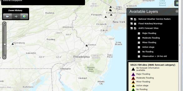
The FIM Mapper allows users to explore the full set of inundation maps that shows where flooding would occur given a selected stream condition.
NJ Coastal Plain Flood Inundation Map
The flood-inundation maps show areas of potential coastal flooding from wind driven storm surge for two different simulated coastal storms.
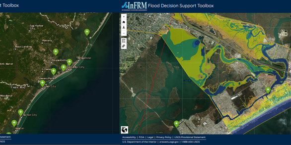
Flood Decision Support Toolbox

Flood-inundation maps for 10 New Jersey counties show areas of potential coastal flooding from wind driven storm surge, which can be used to display a range of tidal elevations to better understand areas of potential flooding.
Flooding can be a serious problem in many parts of New Jersey. Information on floods and analyses of flood data are needed to aid in the design of bridges, culverts, dams, highways, and buildings, and for the prudent management of flood-prone areas. Documentation of floods and a more thorough understanding of flood hydrology and hydraulics will result in more effective management of flood plains and design of structures.
The New Jersey Water Science Center (NJWSC) provides information on the magnitude and frequency of floods to agencies and individuals involved in flood-protection, planning, and design. The NJWSC also develops regional flood-frequency relations for streams in New Jersey to allow flood-frequency determinations at locations without stream gages and conducts local site studies using hydrologic and hydraulic analyses.
Found here are links to Reports Studies, and other useful links to New Jersey Flood Science.
NOTE: Flood peak discharges and estimates of flood recurrence intervals given in older USGS reports and web summaries may have been revised since their original publication.
National Weatehr Service Flood Safety Information

New Jersey Water Science Center Imagery Network

Long-term Water Monitoring Networks in New Jersey

New Jersey: Coastal Flood Inundation Mapping

USGS Flood Information

New Jersey Coastal Surge, Wave, and Tide Hydrodynamics Network (SWaTH)

Floods: Recurrence intervals and 100-year floods Floods: Recurrence intervals and 100-year floods

New Jersey Flood Reports

Hurricanes and Storm-Tide Monitoring
The USGS reports document New Jersey floods from 1896 to the present. Early spring and winter flooding in New Jersey tends to occur as a result of widespread, steady rain of moderate intensity that falls on frozen ground. Snow and ice melt may increase the chance of winter flooding. Summer flooding resulting from thunderstorms typically occurs in small streams and is of local extent. Late summer and fall flooding associated with frontal storms, tropical storms and hurricanes can be widespread, resulting from heavy intense rains across the entire state. New Jersey's major floods are those that are the most severe in terms of magnitude, areal extent, loss of life, and property damage.
USGS Flood Inundation Mapper
The FIM Mapper allows users to explore the full set of inundation maps that shows where flooding would occur given a selected stream condition.
NJ Coastal Plain Flood Inundation Map
The flood-inundation maps show areas of potential coastal flooding from wind driven storm surge for two different simulated coastal storms.
Flood Decision Support Toolbox
Flood-inundation maps for 10 New Jersey counties show areas of potential coastal flooding from wind driven storm surge, which can be used to display a range of tidal elevations to better understand areas of potential flooding.
Flooding can be a serious problem in many parts of New Jersey. Information on floods and analyses of flood data are needed to aid in the design of bridges, culverts, dams, highways, and buildings, and for the prudent management of flood-prone areas. Documentation of floods and a more thorough understanding of flood hydrology and hydraulics will result in more effective management of flood plains and design of structures.
The New Jersey Water Science Center (NJWSC) provides information on the magnitude and frequency of floods to agencies and individuals involved in flood-protection, planning, and design. The NJWSC also develops regional flood-frequency relations for streams in New Jersey to allow flood-frequency determinations at locations without stream gages and conducts local site studies using hydrologic and hydraulic analyses.
Found here are links to Reports Studies, and other useful links to New Jersey Flood Science.
NOTE: Flood peak discharges and estimates of flood recurrence intervals given in older USGS reports and web summaries may have been revised since their original publication.
National Weatehr Service Flood Safety Information
New Jersey Water Science Center Imagery Network
Long-term Water Monitoring Networks in New Jersey
New Jersey: Coastal Flood Inundation Mapping
USGS Flood Information
New Jersey Coastal Surge, Wave, and Tide Hydrodynamics Network (SWaTH)
Floods: Recurrence intervals and 100-year floods Floods: Recurrence intervals and 100-year floods
New Jersey Flood Reports