
Groundwater Sustainability of the Long Island Aquifer System
Groundwater Sustainability
Ensuring a regionally sustainable groundwater resource
Project Component 1: Hydrogeologic-Framework Mapping
Understanding the ground and water beneath our feet
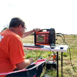
Project Component 2: Saltwater-Interface Mapping
Tracking the extent of saltwater intrusion
Project Component 3: Groundwater-Flow Model
Developing a regional model for the Long Island aquifer system
The U.S. Geological Survey (USGS) has partnered with the New York State Department of Environmental Conservation (NYSDEC) to conduct a comprehensive study of the Long Island aquifer system. The major findings of this investigation include:
The location of the boundary between fresh and salty groundwater is much closer to the shoreline than previously thought.
The historical onshore saltwater intrusion in Brooklyn and Queens has not receded despite the cessation of groundwater withdrawals since the early 1990s.
Although saltwater intrusion is an important concern for coastal communities on Long Island, the groundwater modeling analysis indicates only minor changes in the regional freshwater volume since predevelopment conditions.
Increases in aquifer recharge and sea level in response to climate change can increase groundwater levels and streamflows creating concerns for groundwater flooding in subterranean infrastructure in low-lying areas where the unsaturated zone is already thin.
Latest Products
Hydrogeologic framework of western Long Island
Framework Mapper
Phase I: Simulation of groundwater flow in the Long Island aquifer system
Model Results Viewer
Project Overview
This study provides the information needed to assess water quantity, saltwater intrusion, and effects on ponds, streams, wetlands, and coastal waters from reduced groundwater outflow and to help manage aquifer sustainability. This USGS groundwater sustainability study has three major components:
- Updating hydrogeologic (aquifer sediment) maps.
- Determining the present day [2019] location of the freshwater/saltwater interface.
- Developing a groundwater-flow model to predict the most likely outcomes of potential management decisions and changes in environmental conditions.
Project Components
Project Component 1: Hydrogeologic-Framework Mapping
Project Component 2: Saltwater-Interface Mapping
Project Component 3: Groundwater Flow Modeling
Background
Most of Long Island, New York is entirely dependent on the underlying sole-source aquifer system, which currently supplies over 400 million gallons a day (MGD) of freshwater from more than 1,500 public-supply wells to over 2.8 million people in Nassau and Suffolk Counties. As the name implies, Long Island’s sole-source aquifer system is the only source of water available to meet the needs of the Island’s population.
Long Island’s aquifer system is comprised of several freshwater zones, or “aquifers”, generally ranging in increasing depth from the upper glacial, North Shore, Jameco, Magothy, and finally the Lloyd aquifer. Several major clay layers are also present including the Gardiners Clay and Raritan confining unit, which overlie most but not all of the Magothy and Lloyd aquifers, respectively. These clay units influence the aquifer system in several ways: 1) they act to confine and isolate the underlying freshwater zones, 2) they limit the rate of recharge to the units below, 3) they protect the underlying freshwater from surface contaminants, and 4) in coastal marine environments, they also influence the formation of seaward extended freshwater-aquifer wedges under natural-discharge conditions, and conversely, formation of inland saltwater-intrusion wedges under pumping conditions.
In some areas of Long Island, freshwater pumping has resulted in saltwater intrusion into the aquifer system and has also impacted streams, ponds, and coastal wetlands and estuaries that rely on groundwater discharge to sustain them. Additional human related activities, such as urban runoff and septic systems, have also affected the water quality of the aquifer system. Therefore, development and use of groundwater on Long Island is constrained by ecohydrological (i.e. the interactions between groundwater and surface-water ecosystems) and water-quality concerns.
Concerns
Groundwater is the primary source of freshwater in streams, lakes, and wetlands, and maintains the saline balance of estuaries. When large amounts of groundwater are withdrawn from the aquifer system, the water table is locally depressed, which in turn reduces the amount of groundwater available to discharge to streams, wetlands, and estuaries. Large-scale sewering practices have also reduced groundwater levels and discharge to surface-receiving waters.
Groundwater quality on Long Island has been impaired by saltwater intrusion and human activities. Increased saltwater intrusion from groundwater pumping has occurred in the Lloyd and Magothy aquifers on western Long Island since the 1940s (Cartwright, 2002), and in Suffolk County since the 1970s (Nemickas and Kozalka, 1982).
Contamination by human activities can be from point sources, such as industrial and commercial facilities, or from diffuse (nonpoint) sources such as domestic wastewater, road salt, fertilizers, pesticides, etc. Of particular concern, in Suffolk County, is the return of domestic wastewater to groundwater from septic systems.
Approach
The approach for this investigation consisted of three main components: hydrogeologic-framework mapping, saltwater-interface mapping, and groundwater-flow modeling. The hydrogeologic framework component provided updated hydrostratigraphic surfaces and unit extents, building upon the last regional framework update of the Long Island aquifer system performed by the USGS in 1990 (Smolensky and others, 1990). As part of this update, a network of new groundwater wells were installed at about 25 locations in the Lloyd and Magothy aquifers throughout the Island to fill in substantial data gaps. The locations of the groundwater wells were selected by reviewing geologic, hydrologic, and water-quality information from the existing observation network. During and after completion of the newly drilled wells, lithologic core samples were collected and analyzed to improve the understanding of the hydrogeologic framework. Borehole-geophysical logging techniques were also used to provide additional information on the geology as well as aquifer salinity as part of the saltwater-interface mapping component of the investigation.
The saltwater-interface mapping component used borehole-geophysical logs collected at existing and newly installed wells and surface-geophysical soundings using Time-Domain Electromagnetic (TDEM) technology (Stumm and others, 2021) at selected inland locations considered most susceptible to saltwater intrusion to delineate the seaward extent of freshwater in the Long Island aquifer system. This effort will build upon earlier studies conducted at a much coarser scale throughout the Northern Atlantic Coastal Plain aquifer system. (Charles, 2016).
A two-phased modeling approach was used to simulate groundwater-flow conditions throughout the Long Island aquifer system. This includes:
- An initial model based on existing information for current (2005–2015) average conditions (Walter and others, 2020)
- The addition of time-varying stresses to simulate changes in hydrologic conditions from (1900–2019) (Walter and others, 2024).
The final model was used to simulate various scenarios, including changes in groundwater withdrawals, aquifer-recharge management, and climate change. These scenarios will be developed in collaboration with the New York State Department of Environmental Conservation and the project Steering Committee.
The status of the Framework and Groundwater Model components of the study are presented below. The Reports Status includes the final products from the Phase I component of the investigation and a listing of the previously published interim products.
Framework Status

The phase one drilling effort has been completed. The map showing the well sites and the link to the lithologic and geophysical logs are now available. The phase two drilling effort for central and eastern Long Island began in the fall of 2021. The map showing the completed and proposed wells in now available.
Groundwater Model Status

A 20-layer, transient groundwater flow model was developed that simulates the movement of the boundary between the fresh and saltwater groundwater systems under changing pumping and recharge conditions from 1900 to 2019 (Walter and others, 2024). This model is in addition to the previously developed steady-state flow model documented in Walter and others (2020).

Hydrogeologic-Framework Mapping - Long Island, New York
Saltwater-Interface Mapping - Long Island, New York

Groundwater Flow Modeling - Long Island, New York
The phase one drilling effort has been completed, and the phase two drilling effort for central and eastern Long Island began in the fall of 2021. The maps below show the well sites and link to the lithologic and geophysical logs.
Phase1
The phase one drilling effort has been completed. The map showing the well sites and the link to the lithologic and geophysical logs are now available.
Phase2

The phase two drilling effort for central and eastern Long Island began in the fall of 2021. The map showing the completed and proposed wells in now available.
The status of the Framework and Groundwater Model components of the study are presented below. The Reports Status includes the final products from the Phase I component of the investigation and a listing of the previously published interim products.
Framework Status
The phase one drilling effort has been completed. The map showing the well sites and the link to the lithologic and geophysical logs are now available. The phase two drilling effort for central and eastern Long Island began in the fall of 2021. The map showing the completed and proposed wells in now available.
Groundwater Model Status
A 20-layer, transient groundwater flow model was developed that simulates the movement of the boundary between the fresh and saltwater groundwater systems under changing pumping and recharge conditions from 1900 to 2019 (Walter and others, 2024). This model is in addition to the previously developed steady-state flow model documented in Walter and others (2020).
Hydrogeologic-Framework Mapping - Long Island, New York
Saltwater-Interface Mapping - Long Island, New York
Groundwater Flow Modeling - Long Island, New York
The phase one drilling effort has been completed, and the phase two drilling effort for central and eastern Long Island began in the fall of 2021. The maps below show the well sites and link to the lithologic and geophysical logs.
Phase1
The phase one drilling effort has been completed. The map showing the well sites and the link to the lithologic and geophysical logs are now available.
Phase2
The phase two drilling effort for central and eastern Long Island began in the fall of 2021. The map showing the completed and proposed wells in now available.