
Natural Hazards
Natural Hazards
New Jersey Hazards Information Pages contain additional resources and links for each specific hazard.

Hazards Quicklinks
Hazards Quicklinks
Quickly find information on different types of natural hazards in New Jersey
Filter Total Items: 17
City of Elizabeth Flood Mapping
To better protect the City of Elizabeth’s residents and assets, the U.S. Geological Survey (USGS) and Rutgers University proposed a joint collaboration to develop a reliable flood risk management platform with the cooperation of the City of Elizabeth and the New Jersey Office of Emergency Management. Our understanding is the broader goal for the City of Elizabeth is to accomplish three primary...

New Jersey Tide Network
The USGS operates the most extensive network of tide-gaging stations in the region, many of which form the backbone of flood-warning and storm-hazard warning systems. The New Jersey Water Science Center monitors data for estuary and back-bay areas all along the New Jersey coast and links to related projects with more information about coastal flood hazards, water quality, and other topics. This...
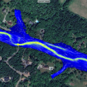
Flooded Roadway and Bridge Crossing Mapping and Early Warning System for Selected Communities in Hunterdon County, New Jersey
This project seeks to develop methods to identify when a flooded roadway or bridge crossing condition may exist and to provide a tool for users to select rainfall scenarios in addition to the selected river condition to estimate if road flooding may occur with the selected combination. These tools will provide officials in Hunterdon County and at the state level of management better early warning...

Flood Resources
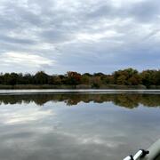
The USGS reports document New Jersey floods from 1896 to the present. Early spring and winter flooding in New Jersey tends to occur as a result of widespread, steady rain of moderate intensity that falls on frozen ground. Snow and ice melt may increase the chance of winter flooding. Summer flooding resulting from thunderstorms typically occurs in small streams and is of local extent. Late summer...

New Jersey Water Science Center Imagery Network
Static webcams have been installed at a number of real-time stream-gaging locations in New Jersey to allow you to view the current river-stage conditions. These webcams provide valuable information to the National Weather Service, emergency managers, and area residents to evaluate real-time conditions in river and coastal environments during storms.

Landslide Resources
The New Jersey Geological and Water Survey maintains a database of Landslides in the state and updates the database as new landslides occur. This information is used by The NJ State Police, Office of Emergency Management as well as federal, state, county, and local government officials and consultants to assist in hazard mitigation planning. Landslides in New Jersey can damage homes, utilities...

Earthquake Resources
Earthquakes felt in New Jersey are generally few and small. However, some earthquakes have produced damage in New Jersey. New Jersey’s seismic hazard is lower than many earthquake-prone parts of the United States. Across the state, seismic hazards are highest in northeastern New Jersey.

Drought Resources of New Jersey
Conditions of moisture deficit sufficient to have an adverse effect on streamflow, groundwater levels, vegetation, animals, and man over a sizeable area.

New Jersey: Coastal Flood Inundation Mapping
The U.S. Geological Survey (USGS) in cooperation with the New Jersey Department of Environmental Protection and New Jersey Office of Emergency Management conducted a study to produce flood-inundation maps for storm surge flooding scenarios in the coastal areas of 10 New Jersey counties. The coastal storm-surge inundation maps were created from data modelled in the FEMA Region II Coastal Storm...

Hurricane Sandy Science, Ten-years Later
On October 29, 2012, Hurricane Sandy made landfall in New Jersey after several days of impacting the Atlantic coastline. Ten years later the impacted communities have recovered and rebuilt, and the New Jersey Water Science Center has expanded its scientific understanding of storm impacts on our state.

Groundwater-Level Response to Earthquakes
Did you know that earthquakes can cause changes in groundwater levels? Very large earthquakes can even cause water-level fluctuations in some wells thousands of miles away, depending on the local geological conditions around the well.

Research and Investigations
The NJWSC conducts research and investigations related to topics such as groundwater and surface-water quality related to anthropogenic and agricultural activities, hydraulic and hydrologic modeling, tracking the movement of groundwater contamination, groundwater resource assessments and modeling, ecological assessments and response to urbanization, and estimating water-use for human and...