



The Great Barrier Reef arches over 2000 kilometers along the northeast coast of Australia. The white calcium carbonate that coats the coral reflects light, making the water above the reef appear bright blue from space.
Images
Pacific Coastal and Marine Science Center images.
Filter Total Items: 1407

Great Barrier Reef satellite image
The Great Barrier Reef arches over 2000 kilometers along the northeast coast of Australia. The white calcium carbonate that coats the coral reflects light, making the water above the reef appear bright blue from space.

Resurrection Bay multibeam imagery
Sonar-generated image showing underwater topography and the potential for landslides near the head of Resurrection Bay, Alaska. The terrain looks three times as steep as it occurs naturally. The arrow points to underwater landslide debris from the collapse of a fan-delta following the great Alaskan earthquake of 1964.
Sonar-generated image showing underwater topography and the potential for landslides near the head of Resurrection Bay, Alaska. The terrain looks three times as steep as it occurs naturally. The arrow points to underwater landslide debris from the collapse of a fan-delta following the great Alaskan earthquake of 1964.

Island-hopping Coral Larvae in Hawaii
Large-scale poster describing USGS work.

Spectral Analysis of Surface Waves testing
The preferred method of SASW testing uses a continuous harmonic-wave source produced by a low-frequency computer-controlled electromechanical shaker (device at right) and multi-sensor linear seismometer arrays (2-sensors on the left). This site is 600-PS11, at Trans Alaska Pipeline, Alyeska Pump Station 11, Glennallen, Alaska.
The preferred method of SASW testing uses a continuous harmonic-wave source produced by a low-frequency computer-controlled electromechanical shaker (device at right) and multi-sensor linear seismometer arrays (2-sensors on the left). This site is 600-PS11, at Trans Alaska Pipeline, Alyeska Pump Station 11, Glennallen, Alaska.

Ocean current-following surface drifters
Map showing the paths that ocean current-following surface drifters deployed in coral larval slicks off west Maui traveled in 24 hours following their release during a coral spawning event. Such data suggests that the coral reefs off west-central Maui may provide coral larvae to the reefs off northeastern Lānaʻi.
Map showing the paths that ocean current-following surface drifters deployed in coral larval slicks off west Maui traveled in 24 hours following their release during a coral spawning event. Such data suggests that the coral reefs off west-central Maui may provide coral larvae to the reefs off northeastern Lānaʻi.

Coral Larvae
Underwater photograph of larvae being released into the water column from reef-building coral spawning off Maui the night of June 30, 2003. The white larvae are about 0.5 to 1.5 mm across.
Underwater photograph of larvae being released into the water column from reef-building coral spawning off Maui the night of June 30, 2003. The white larvae are about 0.5 to 1.5 mm across.

Atoll development
Coral atolls develop from reefs fringing volcanic islands. As first hypothesized by Charles Darwin, and confirmed by ocean drilling done by British scientists a century ago, reefs fringing volcanic islands build vertically to sea level, forming steep-walled barrier reefs.
Coral atolls develop from reefs fringing volcanic islands. As first hypothesized by Charles Darwin, and confirmed by ocean drilling done by British scientists a century ago, reefs fringing volcanic islands build vertically to sea level, forming steep-walled barrier reefs.

Coral reef block diagram
Many coral reefs fringing coasts consist of nearshore inner reef flats that slope to deeper water fore reefs farther offshore. The reef crest, between the inner reef flat and outer fore reef, lies in extremely shallow water and may be exposed during the lowest tides. Waves commonly crash against or break on the reef crest.
Many coral reefs fringing coasts consist of nearshore inner reef flats that slope to deeper water fore reefs farther offshore. The reef crest, between the inner reef flat and outer fore reef, lies in extremely shallow water and may be exposed during the lowest tides. Waves commonly crash against or break on the reef crest.

Los Angeles Margin and Basin
Overall perspective view of the Los Angeles Margin and Basin looking northeast. The distance across the bottom of the image is about 100 kilometers with a vertical exaggeration of 6 times. The margin is bisected by a series of large underwater canyons, channels, and gullies.
Overall perspective view of the Los Angeles Margin and Basin looking northeast. The distance across the bottom of the image is about 100 kilometers with a vertical exaggeration of 6 times. The margin is bisected by a series of large underwater canyons, channels, and gullies.

Coastal cliffs near Fort Funston in 2002
Photograph of a coastal cliff where a large landslide occurred between 2002 and 2010. This photo, taken in 2002, shows the cliff before the landslide.
Photograph of a coastal cliff where a large landslide occurred between 2002 and 2010. This photo, taken in 2002, shows the cliff before the landslide.

Mapping Crater Lake, Oregon
Large-scale poster describing USGS work.
The USGS mapped Crater Lake, Oregon using sonar, in cooperation with the National Park Service, the University of New Hampshire, and C&C Technologies.
Large-scale poster describing USGS work.
The USGS mapped Crater Lake, Oregon using sonar, in cooperation with the National Park Service, the University of New Hampshire, and C&C Technologies.

Bed of manganese nodules
A bed of manganese nodules from deep offshore of the Cook Islands. Each color bar in the staff represents 10 centimeters.
A bed of manganese nodules from deep offshore of the Cook Islands. Each color bar in the staff represents 10 centimeters.

Cook Islands manganese nodules
A bed of manganese nodules from deep offshore of the Cook Islands; photo sourced from Hein et al., 2015, taken during a Japanese research cruise in the year 2000. Nodules range from about 2 to 10 centimeters across.
A bed of manganese nodules from deep offshore of the Cook Islands; photo sourced from Hein et al., 2015, taken during a Japanese research cruise in the year 2000. Nodules range from about 2 to 10 centimeters across.


Oil well pumping unit, south area of the La Honda oil field, CA
Oil well pumping unit, south area of the La Honda oil field, CAThe south area of the La Honda oil field, California, was discovered during the late 1950s and produced an estimated 595,000 barrels of oil from about 12 wells, including the well in this photo.
Oil well pumping unit, south area of the La Honda oil field, CA
Oil well pumping unit, south area of the La Honda oil field, CAThe south area of the La Honda oil field, California, was discovered during the late 1950s and produced an estimated 595,000 barrels of oil from about 12 wells, including the well in this photo.

Earthquake starts tsunami
An earthquake along a subduction zone happens when the leading edge of the overriding plate breaks free and springs seaward, raising the sea floor and the water above it. This uplift starts a tsunami. Meanwhile, the bulge behind the leading edge collapses, thinning the plate and lowering coastal areas.
An earthquake along a subduction zone happens when the leading edge of the overriding plate breaks free and springs seaward, raising the sea floor and the water above it. This uplift starts a tsunami. Meanwhile, the bulge behind the leading edge collapses, thinning the plate and lowering coastal areas.

Mapping Shipping Hazards in San Francisco Bay, 1997-1998
Mapping Shipping Hazards in San Francisco Bay, 1997-1998Large-scale poster describing USGS work.
The USGS mapped western San Francisco Bay using sonar, in cooperation with the National Oceanic and Atmospheric Administration (NOAA) and C&C Technologies. Some parts of the Bay floor are so shallow that a large tanker or container ship could run aground at low tide and create a massive oil spill.
Mapping Shipping Hazards in San Francisco Bay, 1997-1998
Mapping Shipping Hazards in San Francisco Bay, 1997-1998Large-scale poster describing USGS work.
The USGS mapped western San Francisco Bay using sonar, in cooperation with the National Oceanic and Atmospheric Administration (NOAA) and C&C Technologies. Some parts of the Bay floor are so shallow that a large tanker or container ship could run aground at low tide and create a massive oil spill.

Sonar in the Grand Canyon, 1992
George Tate (right, in light baseball cap) drives a raft on the Colorado River in Grand Canyon, 1992. The crane near the bow was used to deploy a small tripod holding a rotating sidescan sonar, which sat on the riverbed recording the motion of underwater sand dunes.
George Tate (right, in light baseball cap) drives a raft on the Colorado River in Grand Canyon, 1992. The crane near the bow was used to deploy a small tripod holding a rotating sidescan sonar, which sat on the riverbed recording the motion of underwater sand dunes.
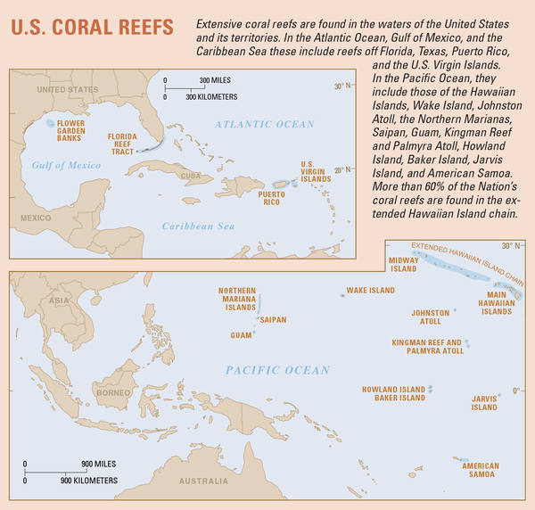
Map showing extent of U.S. coral reefs
Extensive coral reefs are found in the waters of the United States and its territories. In the Atlantic Ocean, Gulf of America, and the Caribbean Sea these include reefs off Florida, Texas, Puerto Rico, and the U.S. Virgin Islands.
Extensive coral reefs are found in the waters of the United States and its territories. In the Atlantic Ocean, Gulf of America, and the Caribbean Sea these include reefs off Florida, Texas, Puerto Rico, and the U.S. Virgin Islands.

Loma Prieta earthquake, Marina District
An automobile lies crushed under the third story of this apartment building in the Marina District. The ground levels are no longer visible because of structural failure and sinking due to liquefaction.
An automobile lies crushed under the third story of this apartment building in the Marina District. The ground levels are no longer visible because of structural failure and sinking due to liquefaction.

Giant Hawaiian Underwater Landslides
Large-scale poster describing USGS work.
The USGS, in cooperation with the UK Institute of Oceanographic Sciences (IOS) and others, took images of the seafloor 200 miles around the Hawaiian Islands using GLORIA. GLORIA is a long-range sonar that gives a bird’s-eye view of the seafloor.
Large-scale poster describing USGS work.
The USGS, in cooperation with the UK Institute of Oceanographic Sciences (IOS) and others, took images of the seafloor 200 miles around the Hawaiian Islands using GLORIA. GLORIA is a long-range sonar that gives a bird’s-eye view of the seafloor.