Shaun Donmoyer and Zachary Houston sampling for ALCOSAN project
Shaun Donmoyer and Zachary Houston sampling for ALCOSAN projectShaun Donmoyer and Zachary Houston sampling at the point location, three rivers, Pittsburgh PA (Jared Carte, USGS).

Official websites use .gov
A .gov website belongs to an official government organization in the United States.
Secure .gov websites use HTTPS
A lock () or https:// means you’ve safely connected to the .gov website. Share sensitive information only on official, secure websites.
Pennsylvania Water Science Center Images

Shaun Donmoyer and Zachary Houston sampling at the point location, three rivers, Pittsburgh PA (Jared Carte, USGS).
Shaun Donmoyer and Zachary Houston sampling at the point location, three rivers, Pittsburgh PA (Jared Carte, USGS).
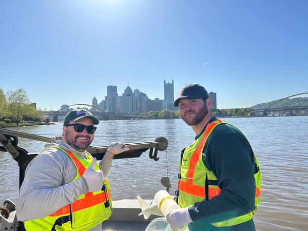
Shaun Donmoyer and Zachary Houston, USGS Pennsylvania Water Science Center, sampling for stream water quality, ALCOSAN project, Pittsburgh, (Jared Carte, USGS).
Initial sampling for monitoring before and after a project to update combined sewer overflow systems in the Pittsburgh area.
Shaun Donmoyer and Zachary Houston, USGS Pennsylvania Water Science Center, sampling for stream water quality, ALCOSAN project, Pittsburgh, (Jared Carte, USGS).
Initial sampling for monitoring before and after a project to update combined sewer overflow systems in the Pittsburgh area.

Shaun Donmoyer and Zach Houston are collecting a water sample to characterize water quality conditions near a combined sewer overflow as part of the Three Rivers Region Water Quality Monitoring with Allegheny County Sanitary Authority project.
Shaun Donmoyer and Zach Houston are collecting a water sample to characterize water quality conditions near a combined sewer overflow as part of the Three Rivers Region Water Quality Monitoring with Allegheny County Sanitary Authority project.
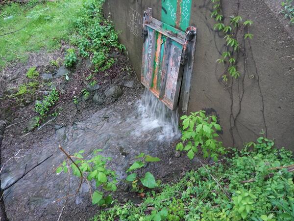
Combined sewer outfall (CSO) at stream sampling location 03085550 Chartiers Creek at Crafton, Pennsylvania, during the wet weather event for the ALCOSAN project (Lee Eicholtz, USGS).
Combined sewer outfall (CSO) at stream sampling location 03085550 Chartiers Creek at Crafton, Pennsylvania, during the wet weather event for the ALCOSAN project (Lee Eicholtz, USGS).

Shohola Creek near Walker Lake, PA (01432495), streamflow monitoring equipment. (USGS)
Shohola Creek near Walker Lake, PA (01432495), streamflow monitoring equipment. (USGS)

Trent Watts, a USGS hydrologic technician, uses an Acoustic Doppler Current Profiler to measure the amount of water flowing in Perkiomen Creek in Graterford, Pennsylvania, on December 18. USGS photo by Cameron Ensor.
Trent Watts, a USGS hydrologic technician, uses an Acoustic Doppler Current Profiler to measure the amount of water flowing in Perkiomen Creek in Graterford, Pennsylvania, on December 18. USGS photo by Cameron Ensor.

New one-half liter bottles of drinking water ("purified water with minerals added for taste"). (Dan Goode, USGS)
New one-half liter bottles of drinking water ("purified water with minerals added for taste"). (Dan Goode, USGS)

Screenshot of title page for "Hurricane Ida: USGS Response in Pennsylvania to September 1-2, 2021, Flooding Related to Remnants of Hurricane Ida" geonarrative.
Screenshot of title page for "Hurricane Ida: USGS Response in Pennsylvania to September 1-2, 2021, Flooding Related to Remnants of Hurricane Ida" geonarrative.

This map shows 161 sites across Pennsylvania that were sampled for PFAS concentrations. The color coding indicates PFAS concentration levels at each site. USGS image.
This map shows 161 sites across Pennsylvania that were sampled for PFAS concentrations. The color coding indicates PFAS concentration levels at each site. USGS image.
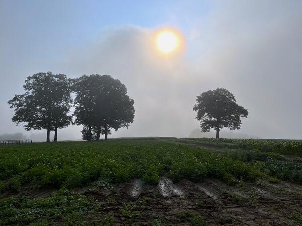
Photo of a field near a site in Pennsylvania where USGS staff take groundwater pesticide samples (USGS).
Photo of a field near a site in Pennsylvania where USGS staff take groundwater pesticide samples (USGS).

A 3D aerial view of Norristown, Pennsylvania shows where the Schuylkill River passes through the city. The water in the river is shown in bright blue, while the surrounding city is shown in natural color.
A 3D aerial view of Norristown, Pennsylvania shows where the Schuylkill River passes through the city. The water in the river is shown in bright blue, while the surrounding city is shown in natural color.

Exposed Hellam Conglomerate member of the Chickies Quartzite at East Mount Zion Superfund Site, York County, Pennsylvania. (Lisa Senior, USGS)
Exposed Hellam Conglomerate member of the Chickies Quartzite at East Mount Zion Superfund Site, York County, Pennsylvania. (Lisa Senior, USGS)

Map of the continental United States indicating the well density per 100 square mile grid cell of 117,672 unplugged orphaned wells in the 27 states included in the documented orphaned oil and gas well (DOW) dataset. Note the exponential scale of the coloring scheme used to preserve detail across both lower and higher well densities.
Map of the continental United States indicating the well density per 100 square mile grid cell of 117,672 unplugged orphaned wells in the 27 states included in the documented orphaned oil and gas well (DOW) dataset. Note the exponential scale of the coloring scheme used to preserve detail across both lower and higher well densities.

Boulder of Hellam Conglomerate member of the Chickies Quartzite at East Mount Zion Superfund Site, York County, Pennsylvania. (Lisa Senior, USGS)
Boulder of Hellam Conglomerate member of the Chickies Quartzite at East Mount Zion Superfund Site, York County, Pennsylvania. (Lisa Senior, USGS)

Survey equipment at Raystown Dam near Huntingdon, Pennsylvania. USGS measures datum (elevation) information as part of monitoring lake level as well as streamflow and stage below the dam. (Victor Cortes, USGS Pennsylvania Water Science Center).
Survey equipment at Raystown Dam near Huntingdon, Pennsylvania. USGS measures datum (elevation) information as part of monitoring lake level as well as streamflow and stage below the dam. (Victor Cortes, USGS Pennsylvania Water Science Center).

The rise and fall of the Delaware River salt front. Over time, the location of the salt front moves in response to regional weather patterns, sea level rise, and human impacts. The precise location of the salt front in the Delaware River Basin is based on the location in the river where the average chloride concentration is 250 mg/L.
The rise and fall of the Delaware River salt front. Over time, the location of the salt front moves in response to regional weather patterns, sea level rise, and human impacts. The precise location of the salt front in the Delaware River Basin is based on the location in the river where the average chloride concentration is 250 mg/L.

USGS scientists sampling water quality from a bridge over Beaver River, near Beaver Falls, Pennsylvania (Natalie Schmer, USGS).
USGS scientists sampling water quality from a bridge over Beaver River, near Beaver Falls, Pennsylvania (Natalie Schmer, USGS).

Schuylkill River Muddy Waters west of Philadelphia, Pennsylvania, September 9, 2021 - Landsat image reproduced in USGS Factsheet Pennsylvania and Landsat. This Landsat image shows the Schuylkill River west of Philadelphia, where muddied waters rose in several communities after the Hurricane Ida delug
Schuylkill River Muddy Waters west of Philadelphia, Pennsylvania, September 9, 2021 - Landsat image reproduced in USGS Factsheet Pennsylvania and Landsat. This Landsat image shows the Schuylkill River west of Philadelphia, where muddied waters rose in several communities after the Hurricane Ida delug

Hydrologic Technician Ian Lynch from the Pittsburgh Field Office of the Pennsylvania Water Science Center takes a high flow measurement at USGS station 03085500, Chartiers Creek at Carnegie, PA during flooding from remnants of Hurricane Ida.
Hydrologic Technician Ian Lynch from the Pittsburgh Field Office of the Pennsylvania Water Science Center takes a high flow measurement at USGS station 03085500, Chartiers Creek at Carnegie, PA during flooding from remnants of Hurricane Ida.

Flooded area at railroad yard in Norristown, Montgomery County, Pennsylvania during Hurricane Ida in September 2021. (USGS)
Flooded area at railroad yard in Norristown, Montgomery County, Pennsylvania during Hurricane Ida in September 2021. (USGS)

Photo Contest Winner | August 2021 | Honorable Mention 2
Nick Grim and Cameron Ensor rescuing a goose that got stuck in fishing line on the Delaware River
Photo Contest Winner | August 2021 | Honorable Mention 2
Nick Grim and Cameron Ensor rescuing a goose that got stuck in fishing line on the Delaware River