
The Southwest Repeat Photography Collection (previously 'Desert Laboratory Repeat Photography Collection')
Repeat Photography Archives at the Southwest Biological Science Center
100+ years of repeat photographic images
Our repeat photographic imagery spans the Southwest US
The points on this webpage represent a small sample of the thousands of photographs in the Repeat Photography Collection
Glen Canyon Dam, 1889 and 1992
The USGS Southwest Repeat Photography Collection contains repeat imagery taken for a variety of research purposes over the last 100+ years. Repeat photographs are taken at precisely the same location at later times to document landscape and other change.
To download individual images, click on 'View and Download' on each image within a slideshow. To view the geographic location of images shown in the slideshows, click on the Study Area map on the right-hand side of this page. A link to each slideshow is accessible if you zoom 🔎 into the map, click on a point, and then right-click on 'View Slideshow.' ➡️
For more information contact Meredith Hartwell at meredith_hartwell@ios.doi.gov
The Southwest Repeat Photography Collection was founded at The Desert Laboratory Research Station on Tumamoc Hill in Tucson, Arizona in 1960 by USGS ecologist, the late Dr. Ray Turner, and expanded over decades by Turner and now-retired USGS scientist Dr. Robert Webb. (It was previously named the Desert Laboratory Repeat Photography Collection.) Thanks to Teo Melis, SBSC Deputy Director, and Helen Fairley, it is now housed and maintained in Flagstaff, Arizona.
In order to preserve the long-term visual record, SBSC inventories and scans the Collection, and provides data and digital images upon request. Geographically, the Collection’s materials range from Utah’s canyonlands south to Arizona's Grand Canyon, Colorado River, and Sonoran Desert, along the borderlands of Arizona and into Mexico, as well as some images from Kenya, in eastern Africa. We show a small sampling of the images here.

Originally developed for surveys and scientific study, repeat photography allows researchers to study how, why and when environmental transformations occurred by capturing comparative images at precisely the same location as a historic photograph.
For example, SBSC scientists are currently using historical photographs from the Collection, including matches made in the early 1990s, to monitor changes in the riparian vegetation along the Colorado River as a response to Glen Canyon Dam operations (Fairley, 2018). To view Helen Fairley's presentation on vegetation change as seen through historic vs. current images, go to: https://www.usbr.gov/uc/progact/amp/twg/2021-01-22-twg-meeting/20210122-AnnualReportingMeeting-UsingRepeatPhotographyDocumentDamOperationEffects-508-UCRO.pdf.
Researchers in Tucson are using the SW Repeat Photography Collection to document changes in saguaro populations in central and southern Arizona.
This research provides valuable opportunities to document, analyze and track change due to anthropogenic (human) and ecological causes. The assessments complement data gathered from GIS, remote sensing, satellite, and aerial imagery, and are used for resource and ecosystem conservation and management.
Watch a short video by AZ PBS about the Repeat Photography Collection:
Enter the USGS Southwest Repeat Photography Collection and Take a Journey Through Time - YouTube

Below are a series of repeat photography slideshows. To expand the slideshow to full screen, select the arrows that point away from each other at the bottom of the slideshow. To download individual images in each slideshow, click on "view and download" while viewing the image you want.


The later photograph by Dr. Ray Turner, USGS, taken in 2010 at this same location shows the return of those tree species. Paloverde and mesquite act as 'nurse trees' to young saguaros, providing protection from cold in winters and shade in summer, thereby enabling a stronger chance of saguaro survival during early growth. SBSC Southwest Repeat Photography Collection stake (camera point) s0013.
Link to slideshow: https://www.usgs.gov/media/slideshows/repeat-photographs-saguaro-national-monument-east-now-saguaro-national-park-rincon


Link to slideshow: https://www.usgs.gov/media/slideshows/repeat-photography-128-mile-rapid-colorado-river-grand-canyon-az


The second photo was taken in 1991 by Dave Edwards, USGS. Field notes document "major beach erosion and invasion of Tamarix and Salix," and plant species documented during 1991 were Acacia greggii, Tamarix, Salix, and Baccharis emoryi. This image was captured at ~10 m above the river on a rock outcropping downstream from the beach, looking upstream.
The third photo was taken in 2002 by an unknown USGS photographer. Note the changes in vegetation, now covering most of the beach. SBSC Southwest Repeat Photography Collection stake (camera point) s2505.
Link to slideshow: https://www.usgs.gov/media/slideshows/repeat-photography-rattlesnake-camp-colorado-river-grand-canyon-river-mile-744


Link to slideshow: https://www.usgs.gov/media/slideshows/repeat-photography-tsegi-canyon-laguna-creek-northern-arizona

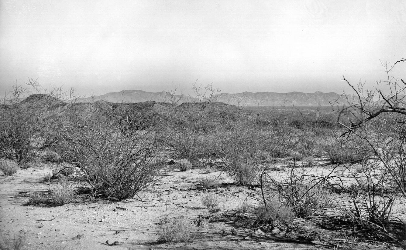
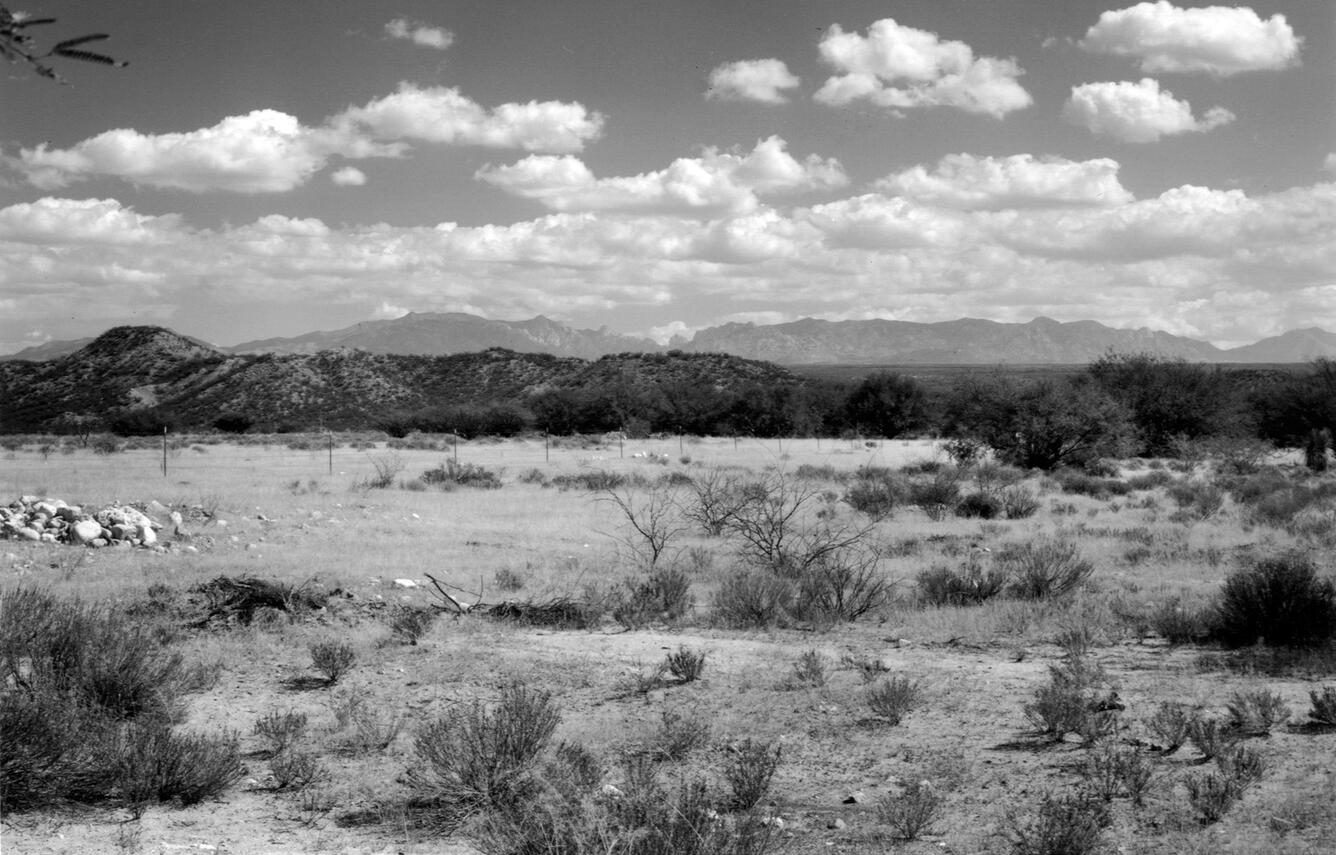
Link to slideshow: https://www.usgs.gov/media/slideshows/repeat-photography-san-pedro-river-valley-near-st-david-southern-az


The later photograph taken in 2015 by Dr. Robert Webb, USGS, shows that channel narrowing and new establishment of cottonwood trees have completely changed the center of this view, which, combined with the clear downcutting effects of recent flooding (note rock exposure in the channel at center), has erased any trace of the former road. Among the new shrub species present, coyote willow and salt bush are perhaps most common. The cottonwoods and Gambel oak established before 1965 remain alive. The USGS and NPS collect and evaluate historic repeat photos for long-term vegetation change. Stake (camera point) s6607.
Link to slideshow: https://www.usgs.gov/media/slideshows/repeat-photography-canyonlands-national-park-utah-1965-and-2015
Link to Glen Canyon Dam slideshow below: https://www.usgs.gov/media/slideshows/repeat-photography-glen-canyon-dam-site-colorado-river-grand-canyon-and-after-its


Excerpt of the Stanton Survey History by Robert H. Webb, USGS, public domain (from the now unavailable webpage on the subject):
In May 1889, railroad engineer Robert Brewster Stanton, in collaboration with real estate investor Frank M. Brown, began a survey of the Green and Colorado River corridors. Their goal was to construct a railroad line from Grand Junction, Colorado to San Diego, California, one that would wind at river-level through several of the Colorado River’s canyons. While that expedition ended in disaster in July after three men—one of them Brown—drowned in Grand Canyon, Stanton successfully completed the survey that winter (1889-1890). The expedition quickly discovered that conducting the survey by instrument was far too time-consuming for their allotted time, so the men turned to line-of-site photographs taken on newfangled flexible roll film (rather than the cumbersome glass plates used by their predecessors). Although the railroad project never got past the planning stages, the photographs would prove to be invaluable as the basis for repeat photography a century later. From 1989 to 1995, the USGS re-photographed nearly all of the images that the expedition’s photographers—Franklin A. Nims and, after Nims was injured and left the expedition, Stanton himself—took in both Grand and Cataract Canyons. The photographs reveal changes in desert and riparian vegetation, rapids, and beaches, as a result of both natural and human-caused processes. Many of the Grand Canyon images were published in the book “Grand Canyon, A Century of Change,” by Robert Webb, and a selection of the Cataract Canyon images appeared in “Cataract Canyon: A Human and Environmental History of the Rivers in Canyonlands,” by Robert Webb, Jayne Belnap, and John Weisheit. In 2010, the USGS re-matched many of the images, both in Grand Canyon and Cataract Canyon.
December 23, 1889: Historic images taken on December 23, 1889 of the Colorado River, River Mile Mile -14.7, near the site where Glen Canyon Dam would later be built. Photographs were taken on river left looking upstream and downstream. For Stanton’s crew, the objective on the morning of December 23 was not just to survey a railroad route but to reach Lee’s Ferry in time for Christmas. They knew that Warren Johnson lived at Lee’s Ferry and expected a feast, a departure from their spartan river fare. They had camped the previous night only a short distance above the current site of Glen Canyon Dam. At 8:30 am, Stanton stopped in a right-hand bend -14.7 miles upstream of Lee’s Ferry. While others surveyed the route, Nims captured this view under cloudy skies. While the Brown-Stanton expedition would eventually switch from an instrument survey to a purely photographic survey of the canyons of the Colorado River in order to save time, at this point, they were still conducting an instrument survey. Three members of the expedition, with plane table and stadia rod, are visible in the center foreground. Shrubs, likely Mormon tea and saltbrush, grow upon the slope in the foreground, while the river’s edge is barren. Photo credits: Franklin A. Nims, original courtesy of The National Archives, #57-RS-235 and #57-RS-236, public domain.
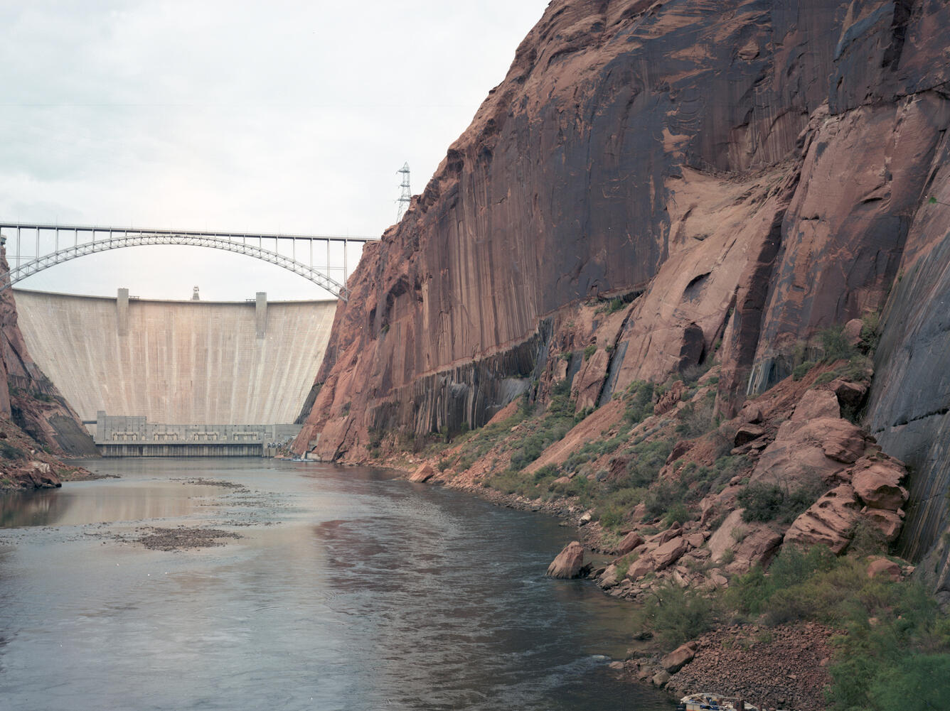
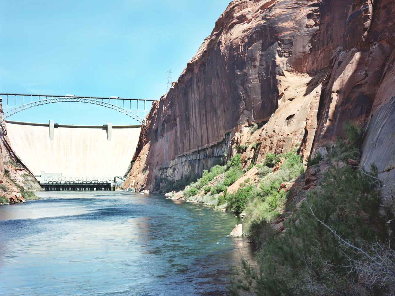
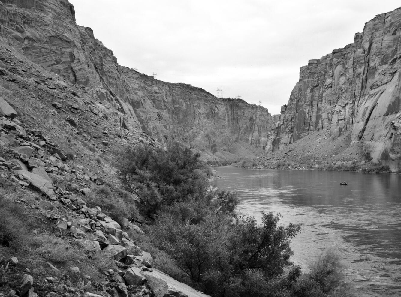
October 29, 1992: USGS repeat photographs near Glen Canyon Dam taken on October 29, 1992, as a match to the 1889 Franklin Nims image of the site before the dam was built, at Colorado River mile -14.7, during the Stanton Expedition. The views are taken from river left looking upstream at the dam and downstream from the dam. In October 1956, the blasting began on the walls of Navajo Sandstone at this once obscure spot. In 1963, Glen Canyon Dam was completed and Lake Powell began to fill. At this point, about one-half mile downstream, a new horizontal stripe on the wall was created by seepage from the reservoir. The small sand bars that lined the banks of the Colorado River in 1889 have eroded away, although a large sand bar is present directly across the river from the camera station. A century later, the presence of Glen Canyon Dam, which is just upstream, affects this view and all others downstream that show the river corridor. Large power poles dominate the skyline, a small power line crosses in the midground, and riparian vegetation, mostly netleaf hackberry and non-native tamarisk, has become established along the river corridor now protected from large floods. The shrubs growing along the slopes include Mormon tea, sand sagebrush, prickly pear cactus, and non-native Russian thistle. A small area of biological soil crust is apparent at lower left. Photo credits: Robert H. Webb, USGS.
April 20, 2011: USGS repeat photographs near Glen Canyon Dam taken on April 20, 2011, as a match to the 1992 USGS and 1889 Nims/Stanton images. The views are taken from river left looking upstream at the dam and downstream from the dam. The vegetation growing along the shoreline has increased. Many of the individual plants persist, and a new netleaf hackberry is visible in the lower right corner of the image. The netleaf hackberry have increased in both stature and number of individuals in the ensuing two decades, and the tamarisk visible along the opposite bank has increased as well. Many of the Mormon tea persist, while some of the four-wing saltbush and sand sagebrush have died, as has prickly pear cactus. The biological soil crust is still present albeit subdued, and the large boulder in the center foreground has rotated. Photo credits: Robert H. Webb, USGS.
The USGS Southwest Repeat Photography Collection contains repeat imagery taken for a variety of research purposes over the last 100+ years. Repeat photographs are taken at precisely the same location at later times to document landscape and other change.
To download individual images, click on 'View and Download' on each image within a slideshow. To view the geographic location of images shown in the slideshows, click on the Study Area map on the right-hand side of this page. A link to each slideshow is accessible if you zoom 🔎 into the map, click on a point, and then right-click on 'View Slideshow.' ➡️
For more information contact Meredith Hartwell at meredith_hartwell@ios.doi.gov
The Southwest Repeat Photography Collection was founded at The Desert Laboratory Research Station on Tumamoc Hill in Tucson, Arizona in 1960 by USGS ecologist, the late Dr. Ray Turner, and expanded over decades by Turner and now-retired USGS scientist Dr. Robert Webb. (It was previously named the Desert Laboratory Repeat Photography Collection.) Thanks to Teo Melis, SBSC Deputy Director, and Helen Fairley, it is now housed and maintained in Flagstaff, Arizona.
In order to preserve the long-term visual record, SBSC inventories and scans the Collection, and provides data and digital images upon request. Geographically, the Collection’s materials range from Utah’s canyonlands south to Arizona's Grand Canyon, Colorado River, and Sonoran Desert, along the borderlands of Arizona and into Mexico, as well as some images from Kenya, in eastern Africa. We show a small sampling of the images here.
Originally developed for surveys and scientific study, repeat photography allows researchers to study how, why and when environmental transformations occurred by capturing comparative images at precisely the same location as a historic photograph.
For example, SBSC scientists are currently using historical photographs from the Collection, including matches made in the early 1990s, to monitor changes in the riparian vegetation along the Colorado River as a response to Glen Canyon Dam operations (Fairley, 2018). To view Helen Fairley's presentation on vegetation change as seen through historic vs. current images, go to: https://www.usbr.gov/uc/progact/amp/twg/2021-01-22-twg-meeting/20210122-AnnualReportingMeeting-UsingRepeatPhotographyDocumentDamOperationEffects-508-UCRO.pdf.
Researchers in Tucson are using the SW Repeat Photography Collection to document changes in saguaro populations in central and southern Arizona.
This research provides valuable opportunities to document, analyze and track change due to anthropogenic (human) and ecological causes. The assessments complement data gathered from GIS, remote sensing, satellite, and aerial imagery, and are used for resource and ecosystem conservation and management.
Watch a short video by AZ PBS about the Repeat Photography Collection:
Enter the USGS Southwest Repeat Photography Collection and Take a Journey Through Time - YouTube
Below are a series of repeat photography slideshows. To expand the slideshow to full screen, select the arrows that point away from each other at the bottom of the slideshow. To download individual images in each slideshow, click on "view and download" while viewing the image you want.
The later photograph by Dr. Ray Turner, USGS, taken in 2010 at this same location shows the return of those tree species. Paloverde and mesquite act as 'nurse trees' to young saguaros, providing protection from cold in winters and shade in summer, thereby enabling a stronger chance of saguaro survival during early growth. SBSC Southwest Repeat Photography Collection stake (camera point) s0013.
Link to slideshow: https://www.usgs.gov/media/slideshows/repeat-photographs-saguaro-national-monument-east-now-saguaro-national-park-rincon
Link to slideshow: https://www.usgs.gov/media/slideshows/repeat-photography-128-mile-rapid-colorado-river-grand-canyon-az
The second photo was taken in 1991 by Dave Edwards, USGS. Field notes document "major beach erosion and invasion of Tamarix and Salix," and plant species documented during 1991 were Acacia greggii, Tamarix, Salix, and Baccharis emoryi. This image was captured at ~10 m above the river on a rock outcropping downstream from the beach, looking upstream.
The third photo was taken in 2002 by an unknown USGS photographer. Note the changes in vegetation, now covering most of the beach. SBSC Southwest Repeat Photography Collection stake (camera point) s2505.
Link to slideshow: https://www.usgs.gov/media/slideshows/repeat-photography-rattlesnake-camp-colorado-river-grand-canyon-river-mile-744
Link to slideshow: https://www.usgs.gov/media/slideshows/repeat-photography-tsegi-canyon-laguna-creek-northern-arizona
Link to slideshow: https://www.usgs.gov/media/slideshows/repeat-photography-san-pedro-river-valley-near-st-david-southern-az
The later photograph taken in 2015 by Dr. Robert Webb, USGS, shows that channel narrowing and new establishment of cottonwood trees have completely changed the center of this view, which, combined with the clear downcutting effects of recent flooding (note rock exposure in the channel at center), has erased any trace of the former road. Among the new shrub species present, coyote willow and salt bush are perhaps most common. The cottonwoods and Gambel oak established before 1965 remain alive. The USGS and NPS collect and evaluate historic repeat photos for long-term vegetation change. Stake (camera point) s6607.
Link to slideshow: https://www.usgs.gov/media/slideshows/repeat-photography-canyonlands-national-park-utah-1965-and-2015
Link to Glen Canyon Dam slideshow below: https://www.usgs.gov/media/slideshows/repeat-photography-glen-canyon-dam-site-colorado-river-grand-canyon-and-after-its
Excerpt of the Stanton Survey History by Robert H. Webb, USGS, public domain (from the now unavailable webpage on the subject):
In May 1889, railroad engineer Robert Brewster Stanton, in collaboration with real estate investor Frank M. Brown, began a survey of the Green and Colorado River corridors. Their goal was to construct a railroad line from Grand Junction, Colorado to San Diego, California, one that would wind at river-level through several of the Colorado River’s canyons. While that expedition ended in disaster in July after three men—one of them Brown—drowned in Grand Canyon, Stanton successfully completed the survey that winter (1889-1890). The expedition quickly discovered that conducting the survey by instrument was far too time-consuming for their allotted time, so the men turned to line-of-site photographs taken on newfangled flexible roll film (rather than the cumbersome glass plates used by their predecessors). Although the railroad project never got past the planning stages, the photographs would prove to be invaluable as the basis for repeat photography a century later. From 1989 to 1995, the USGS re-photographed nearly all of the images that the expedition’s photographers—Franklin A. Nims and, after Nims was injured and left the expedition, Stanton himself—took in both Grand and Cataract Canyons. The photographs reveal changes in desert and riparian vegetation, rapids, and beaches, as a result of both natural and human-caused processes. Many of the Grand Canyon images were published in the book “Grand Canyon, A Century of Change,” by Robert Webb, and a selection of the Cataract Canyon images appeared in “Cataract Canyon: A Human and Environmental History of the Rivers in Canyonlands,” by Robert Webb, Jayne Belnap, and John Weisheit. In 2010, the USGS re-matched many of the images, both in Grand Canyon and Cataract Canyon.
December 23, 1889: Historic images taken on December 23, 1889 of the Colorado River, River Mile Mile -14.7, near the site where Glen Canyon Dam would later be built. Photographs were taken on river left looking upstream and downstream. For Stanton’s crew, the objective on the morning of December 23 was not just to survey a railroad route but to reach Lee’s Ferry in time for Christmas. They knew that Warren Johnson lived at Lee’s Ferry and expected a feast, a departure from their spartan river fare. They had camped the previous night only a short distance above the current site of Glen Canyon Dam. At 8:30 am, Stanton stopped in a right-hand bend -14.7 miles upstream of Lee’s Ferry. While others surveyed the route, Nims captured this view under cloudy skies. While the Brown-Stanton expedition would eventually switch from an instrument survey to a purely photographic survey of the canyons of the Colorado River in order to save time, at this point, they were still conducting an instrument survey. Three members of the expedition, with plane table and stadia rod, are visible in the center foreground. Shrubs, likely Mormon tea and saltbrush, grow upon the slope in the foreground, while the river’s edge is barren. Photo credits: Franklin A. Nims, original courtesy of The National Archives, #57-RS-235 and #57-RS-236, public domain.
October 29, 1992: USGS repeat photographs near Glen Canyon Dam taken on October 29, 1992, as a match to the 1889 Franklin Nims image of the site before the dam was built, at Colorado River mile -14.7, during the Stanton Expedition. The views are taken from river left looking upstream at the dam and downstream from the dam. In October 1956, the blasting began on the walls of Navajo Sandstone at this once obscure spot. In 1963, Glen Canyon Dam was completed and Lake Powell began to fill. At this point, about one-half mile downstream, a new horizontal stripe on the wall was created by seepage from the reservoir. The small sand bars that lined the banks of the Colorado River in 1889 have eroded away, although a large sand bar is present directly across the river from the camera station. A century later, the presence of Glen Canyon Dam, which is just upstream, affects this view and all others downstream that show the river corridor. Large power poles dominate the skyline, a small power line crosses in the midground, and riparian vegetation, mostly netleaf hackberry and non-native tamarisk, has become established along the river corridor now protected from large floods. The shrubs growing along the slopes include Mormon tea, sand sagebrush, prickly pear cactus, and non-native Russian thistle. A small area of biological soil crust is apparent at lower left. Photo credits: Robert H. Webb, USGS.
April 20, 2011: USGS repeat photographs near Glen Canyon Dam taken on April 20, 2011, as a match to the 1992 USGS and 1889 Nims/Stanton images. The views are taken from river left looking upstream at the dam and downstream from the dam. The vegetation growing along the shoreline has increased. Many of the individual plants persist, and a new netleaf hackberry is visible in the lower right corner of the image. The netleaf hackberry have increased in both stature and number of individuals in the ensuing two decades, and the tamarisk visible along the opposite bank has increased as well. Many of the Mormon tea persist, while some of the four-wing saltbush and sand sagebrush have died, as has prickly pear cactus. The biological soil crust is still present albeit subdued, and the large boulder in the center foreground has rotated. Photo credits: Robert H. Webb, USGS.