Geophysical equipment loop with sensor from SKYTEM for electromagnetic (AEM) survey in southwest Wisconsin 2022. In March 2022, a helicopter carried an airborne electromagnetic induction sensor over parts of southeast and southwest Wisconsin as part of a USGS study to map the aquifers in the region.
Airborne Electromagnetic (AEM) Survey 2022
The U.S. Geological Survey (USGS) is conducting an Airborne Electromagnetic (AEM) Survey project in Southwestern and Southeastern Wisconsin.
The survey is in partnership with Wisconsin Geological and Natural History Survey (WGNHS), Natural Resources Conservation Service (NRCS) and Wisconsin Department of Agriculture, Trade and Consumer Protection (DATCP).
What is the survey for?
The survey will use airborne electromagnetic (AEM) technology to better understand how surface water and groundwater are connected, and the geometry of different aquifer units. To accomplish this, AEM data will be collected to image surficial confining units, shallow aquifers, and bedrock units. The use of a helicopter-towed AEM sensor (looks like a large hoop hanging from a cable) for this type of evaluation uses cutting-edge technology and provides accurate science-based data about below-ground properties that are otherwise difficult to assess over large areas. This project is in response to public feedback on groundwater quality, limited data on depth to bedrock, and to further define aquifer properties in relation to surface activities.
When and where will it happen?
Flights are expected to start in late February/early March 2022 and exact dates will be weather dependent. At this time, surveying will take place in the following counties: Grant, Iowa, Lafayette, Green, Waukesha, Walworth, Racine, and Kenosha.
Why is measuring subsurface geology important for water quality?
Much of Wisconsin’s drinking water comes from groundwater and groundwater sources. Degradation of groundwater quality has been a rising concern as well as the influence of groundwater connections to our streams. Having a better understanding of aquifer properties as well as connectivity to the surface (depth to bedrock), allows practical guidance for the development of approaches to maintain a healthy groundwater system. Using AEM allows scientists to develop a 3D image of the subsurface geology to better predict how water moves through those layers and how groundwater and surface water are connected.
How does this benefit the public?
This survey supports public health efforts to help protect groundwater and promote water quality. The results of the survey will:
-
Create a better understanding of aquifer properties
-
Address groundwater quality
-
Improves understanding of the influence of surface activities (agriculture, mining, development, etc.) on groundwater quality
This project uses the strength of local, state, and federal resources to help many citizens in southern Wisconsin.
Helicopter Activity: What to Expect
Map of where the helicopter will be flying:
- Flights are expected to take 14-21 days depending on weather and flight conditions
- The helicopter is flying a grid pre-determined flight track based on study locations, so it will be seen several times in the same area
- The helicopter will fly relatively low, hundreds of feet above ground
- The helicopter will not fly within 500 ft of buildings according to Federal Aviation Administration (FAA) rules, and will make efforts to fly around people or large equipment on the ground
- The electromagnetic device will not harm plants, animals, or humans
- The low flying helicopter may startle wildlife and cattle and the helicopter will make efforts to fly around confined animal areas
- Local enforcement and conservation contacts are informed of the activity
- A flight tracker will map the daily progress of the study
- Only depth to bedrock and hydrogeologic properties will be identified through this process
Additional Information
General footage of the surveying equipment: https://www.youtube.com/watch?v=qSTddN9njuk
Example of how to view and use the data: https://www.youtube.com/watch?v=6fbCZLgQPl8
Contacts
Topic | Agency | Contact | Phone | |
Southwest Wisconsin flight | USGS | Matt Komiskey | mjkomisk@usgs.gov | 608-821-3930 |
AEM survey and flight paths | USGS | Burke Minsley | bminsley@usgs.gov | 303-236-5718 |
Southeast Wisconsin flight | USGS | Jim Duncker | jduncker@usgs.gov | 217-493-7512 |
Southeast Wisconsin flight | USGS | Judith Thomas | juthomas@usgs.gov | 779-400-6583 |
WGNHS | Dave Hart | david.hart@wisc.edu | 608-262-2307 |
Below is media associated with this project.
Geophysical equipment loop with sensor from SKYTEM for electromagnetic (AEM) survey in southwest Wisconsin 2022. In March 2022, a helicopter carried an airborne electromagnetic induction sensor over parts of southeast and southwest Wisconsin as part of a USGS study to map the aquifers in the region.
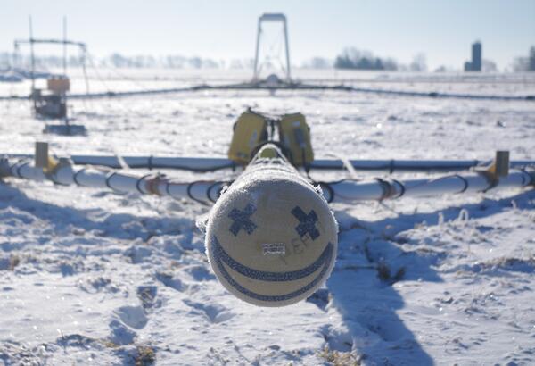
Smiley face on front of electromagnetic (AEM) survey equipment at AEM survey in southwest Wisconsin 2022. In March 2022, a helicopter carried an airborne electromagnetic induction sensor over parts of southeast and southwest Wisconsin as part of a USGS study to map the aquifers in the region.
Helicopter lifting off with geophysical equipment loop on ground below attached via slingload. Technician on ground for scale. In March 2022, a helicopter carried an airborne electromagnetic induction sensor over parts of southeast and southwest Wisconsin as part of a USGS study to map the aquifers in the region.
Helicopter lifting off with geophysical equipment loop below attached via slingload. Technician on ground for scale. In March 2022, a helicopter carried an airborne electromagnetic induction sensor over parts of southeast and southwest Wisconsin as part of a USGS study to map the aquifers in the region.
Airborne electromagnetic (AEM) survey hoop on snowy ground with technician walking by for scale
linkGeophysical equipment loop for airborne electromagnetic (AEM) survey on ground prior to liftoff. Technician on ground for scale. In March 2022, a helicopter carried an airborne electromagnetic induction sensor over parts of southeast and southwest Wisconsin as part of a USGS study to map the aquifers in the region.
Burke Minsley speaking to group of USGS employees and Cooperators at AEM survey in southwest Wisconsin 2022
linkResearch geophysicist Burke Minsley discussing aerial electromagnetic (AEM) survey equipment with group of USGS employees and Cooperators at AEM survey in southwest Wisconsin 2022. In March 2022, a helicopter carried an airborne electromagnetic induction sensor over parts of southeast and southwest Wisconsin as part of a USGS study to map the aquifers in t
Burke Minsley explaining AEM technology to group of USGS employees and Cooperators at AEM survey in southwest Wisconsin 2022
linkResearch geophysicist Burke Minsley discussing aerial electromagnetic (AEM) survey equipment with group of USGS employees and Cooperators at AEM survey in southwest Wisconsin 2022. In March 2022, a helicopter carried an airborne electromagnetic induction sensor over parts of southeast and southwest Wisconsin as part of a USGS study to map the aquifers in t
Research geophysicist Burke Minsley discussing aerial electromagnetic (AEM) survey equipment with group of USGS employees and Cooperators at AEM survey in southwest Wisconsin 2022. In March 2022, a helicopter carried an airborne electromagnetic induction sensor over parts of southeast and southwest Wisconsin as part of a USGS study to map the aquifers in t
Sun shining over group of USGS employees and Cooperators at AEM survey in southwest Wisconsin 2022
linkResearch geophysicist Burke Minsley discussing aerial electromagnetic (AEM) survey equipment with group of USGS employees and Cooperators at AEM survey in southwest Wisconsin 2022. In March 2022, a helicopter carried an airborne electromagnetic induction sensor over parts of southeast and southwest Wisconsin as part of a USGS study to map the aquifers in t
USGS employees and cooperators watching and photographing helicopter lifting off with geophysical equipment loop below attached via slingload. In March 2022, a helicopter carried an airborne electromagnetic induction sensor over parts of southeast and southwest Wisconsin as part of a USGS study to map the aquifers in the region.
Airborne electromagnetic (AEM) survey hoop on snowy ground with technician preparing for liftoff
linkGeophysical equipment loop for airborne electromagnetic (AEM) survey on ground prior to liftoff. Technician on ground for scale. In March 2022, a helicopter carried an airborne electromagnetic induction sensor over parts of southeast and southwest Wisconsin as part of a USGS study to map the aquifers in the region.
Research geophysicist Burke Minsley discussing aerial electromagnetic (AEM) survey equipment with group of USGS employees and Cooperators at AEM survey in southwest Wisconsin 2022. In March 2022, a helicopter carried an airborne electromagnetic induction sensor over parts of southeast and southwest Wisconsin as part of a USGS study to map the aquifers in t
Helicopter used to tow electromagnetic (AEM) survey equipment at AEM survey in southwest Wisconsin 2022. In March 2022, a helicopter carried an airborne electromagnetic induction sensor over parts of southeast and southwest Wisconsin as part of a USGS study to map the aquifers in the region.
Photo of helicopter with geophysical equipment loop deployed below it via slingload. Technician on ground for scale. In March 2022, a helicopter carried an airborne electromagnetic induction sensor over parts of southeast and southwest Wisconsin as part of a USGS study to map the aquifers in the region.
Low-flying helicopter with geophysical equipment loop deployed below it via slingload. In March 2022, a helicopter carried an airborne electromagnetic induction sensor over parts of southeast and southwest Wisconsin as part of a USGS study to map the aquifers in the region.