
A borehole extensometer is an instrument that measures vertical land motion caused by changes in aquifer thickness. A borehole is drilled through the entirety of an aquifer system and the steel pipe is anchored at the base to the basement rock.
Images
Explore our planet and learn more about our work through photographs and imagery from scientists and support staff.
Filter Total Items: 408

Extensometer - Aquifer Compaction
A borehole extensometer is an instrument that measures vertical land motion caused by changes in aquifer thickness. A borehole is drilled through the entirety of an aquifer system and the steel pipe is anchored at the base to the basement rock.
Borehole Extensometer
Borehole Extensometer
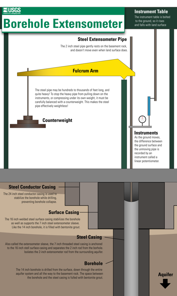
Borehole extensometers are highly sensitive instruments which measure aquifer compaction. This infographic explains the various parts of a borehole extensometer, and is modeled after the USGS extensometer at Nansemond, Virginia.
Borehole Extensometer
Borehole extensometers are highly sensitive instruments which measure aquifer compaction. This infographic explains the various parts of a borehole extensometer, and is modeled after the USGS extensometer at Nansemond, Virginia.

Glacial Isostatic Adjustment
Glacial isostacy is the upward or downward land motion caused by the weight of ice sheets deforming the Earth's crust. The weight of the ice sheet deforms the underlying crust downward and displaces the underlying lithosphere, creating an indentation.
Glacial isostacy is the upward or downward land motion caused by the weight of ice sheets deforming the Earth's crust. The weight of the ice sheet deforms the underlying crust downward and displaces the underlying lithosphere, creating an indentation.

Collecting water quality samples from the New River Gorge
Collecting water quality samples from the New River GorgeCollecting water quality samples from the New River Gorge in support of USGS-NPS partnership.
Fall 2022 Photo Contest Winner: Matt Kearns, USGS at Work category
Collecting water quality samples from the New River Gorge
Collecting water quality samples from the New River GorgeCollecting water quality samples from the New River Gorge in support of USGS-NPS partnership.
Fall 2022 Photo Contest Winner: Matt Kearns, USGS at Work category

Streambank Erosion at Long Branch
Streambank erosion is a common problem in urban watersheds. This heavily eroded streambank is located within the Long Branch watershed in Fairfax County, Virginia. This site is monitored as a part of the Fairfax County Water Resources Monitoring Network.
Streambank erosion is a common problem in urban watersheds. This heavily eroded streambank is located within the Long Branch watershed in Fairfax County, Virginia. This site is monitored as a part of the Fairfax County Water Resources Monitoring Network.

Floodplain Monitoring Site in the Long Branch Watershed, Fairfax, Virginia
Floodplain Monitoring Site in the Long Branch Watershed, Fairfax, VirginiaA floodplain monitoring site along the Long Branch stream. This site is monitored as a part of the Fairfax County Water Resources Monitoring Network.
Floodplain Monitoring Site in the Long Branch Watershed, Fairfax, Virginia
Floodplain Monitoring Site in the Long Branch Watershed, Fairfax, VirginiaA floodplain monitoring site along the Long Branch stream. This site is monitored as a part of the Fairfax County Water Resources Monitoring Network.

Streambank Erosion at the Long Branch Monitoring Site
Streambank Erosion at the Long Branch Monitoring SiteStreambank erosion is a common problem in urban watersheds. This heavily eroded streambank is located within the Long Branch watershed in Fairfax County, Virginia. This site is monitored as a part of the Fairfax County Water Resources Monitoring Network.

Floodplain Monitoring site in the Long Branch Watershed, Fairfax, VA
Floodplain Monitoring site in the Long Branch Watershed, Fairfax, VAA floodplain monitoring site along the Long Branch stream. In this photo, sediment is being deposited in-channel behind a downed tree.
This site is monitored as a part of the Fairfax County Water Resources Monitoring Network.

Bank Erosion at Long Branch
Streambank erosion is a common problem in urban watersheds. This heavily eroded streambank is located within the Long Branch watershed in Fairfax County, Virginia. This site is monitored as a part of the Fairfax County Water Resources Monitoring Network.
Streambank erosion is a common problem in urban watersheds. This heavily eroded streambank is located within the Long Branch watershed in Fairfax County, Virginia. This site is monitored as a part of the Fairfax County Water Resources Monitoring Network.

Prepping Water-Quality Samples for Shipping
Water-quality samples collected as part of a sampling campaign across the Potomac River watershed. Water-quality analyses are time-sensitive. At the end of each sampling day, samples are shipped overnight to the respective water-quality labs.
Water-quality samples collected as part of a sampling campaign across the Potomac River watershed. Water-quality analyses are time-sensitive. At the end of each sampling day, samples are shipped overnight to the respective water-quality labs.

Antietam Creek below Hagerstown, Maryland
Antietam Creek below Hagerstown, Maryland (U.S. Geological Survey site identifier 01619270).
Antietam Creek below Hagerstown, Maryland (U.S. Geological Survey site identifier 01619270).
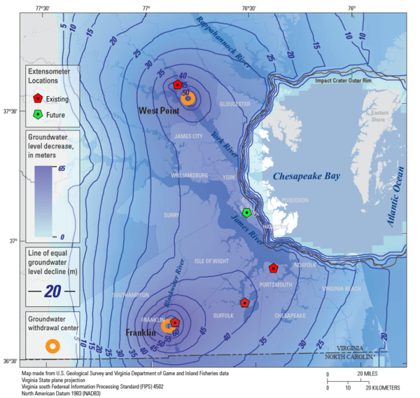
Virginia Extensometer Network
This map shows the locations of the four existing extensometers (red) in the USGS' Virginia Extensometer Network with the location of a fifth future extensometer (green). The basemap is of the Virginia Coastal Plain and shows the severity of groundwater depletion, with darker blue indicating greater groundwater depletion.
This map shows the locations of the four existing extensometers (red) in the USGS' Virginia Extensometer Network with the location of a fifth future extensometer (green). The basemap is of the Virginia Coastal Plain and shows the severity of groundwater depletion, with darker blue indicating greater groundwater depletion.
Capturing an elevated stage (storm-impacted) water quality sample
Capturing an elevated stage (storm-impacted) water quality sampleUSGS scientist Doug Moyer capturing an elevated stage (storm-impacted) water quality sample at the South Fork Shenandoah River near Lynnwood, VA.
Data for this monitoring site can be found at USGS Water Data for the Nation.

Aquifer compaction and land subsidence
This animated infographic shows how aquifer compaction can lead to land subsidence. When water is pumped from a confined aquifer faster than it can recharge, the water pressure in the aquifer begins to decrease. As water pressure decreases, both the confining layers and the aquifers themselves can start to compact under the weight of the overlying sediments.
This animated infographic shows how aquifer compaction can lead to land subsidence. When water is pumped from a confined aquifer faster than it can recharge, the water pressure in the aquifer begins to decrease. As water pressure decreases, both the confining layers and the aquifers themselves can start to compact under the weight of the overlying sediments.

Assessment of Per- and Polyfluoroalkyl Substances (PFAS) in West Virginia Public Source-Water Supplies
Assessment of Per- and Polyfluoroalkyl Substances (PFAS) in West Virginia Public Source-Water SuppliesWhat are PFAS?

The USGS Nansemond Extensometer
The USGS Nansemond pipe extensometer (59D 39) with a total depth of 1,960 feet. Data for this site can be found on USGS Water Data for the Nation.
The USGS Nansemond pipe extensometer (59D 39) with a total depth of 1,960 feet. Data for this site can be found on USGS Water Data for the Nation.
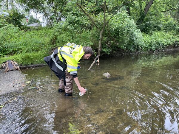
Hydrologic technician Erik Kaseloo collecting a water quality sample
Hydrologic technician Erik Kaseloo collecting a water quality sampleHydrologic technician Erik Kaseloo collecting a water quality sample from Indian Run in Fairfax County. Part of the Fairfax County Water Resources Monitoring Network.
Data for this site can be found at USGS Water Data for the Nation.

Measuring discharge - The Glade, Reston, VA
A USGS scientist measures stream discharge at The Glade, an urban stream in Reston, Virginia.
A USGS scientist measures stream discharge at The Glade, an urban stream in Reston, Virginia.

Geodetic Surveying Tripod
This photograph shows a high-accuracy geodetic surveying tripod used to measure vertical land motion.
This photograph shows a high-accuracy geodetic surveying tripod used to measure vertical land motion.

Benthic Macroinvertebrate Sampling – Snakeden Branch, Reston, VA
Benthic Macroinvertebrate Sampling – Snakeden Branch, Reston, VAA USGS scientist samples for benthic macroinvertebrates at Snakeden Branch, Reston, VA
Benthic Macroinvertebrate Sampling – Snakeden Branch, Reston, VA
Benthic Macroinvertebrate Sampling – Snakeden Branch, Reston, VAA USGS scientist samples for benthic macroinvertebrates at Snakeden Branch, Reston, VA

Benthic Macroinvertebrate Sampling – The Glade, Reston, VA
Benthic Macroinvertebrate Sampling – The Glade, Reston, VAUSGS scientists conduct benthic macroinvertebrate sampling at The Glade in Reston, Virginia
Benthic Macroinvertebrate Sampling – The Glade, Reston, VA
Benthic Macroinvertebrate Sampling – The Glade, Reston, VAUSGS scientists conduct benthic macroinvertebrate sampling at The Glade in Reston, Virginia