Benthic Macroinvertebrate Sampling – The Glade, Reston, VA
Benthic Macroinvertebrate Sampling – The Glade, Reston, VAUSGS scientists conduct benthic macroinvertebrate sampling at The Glade in Reston, Virginia

Official websites use .gov
A .gov website belongs to an official government organization in the United States.
Secure .gov websites use HTTPS
A lock () or https:// means you’ve safely connected to the .gov website. Share sensitive information only on official, secure websites.
Explore our planet and learn more about our work through photographs and imagery from scientists and support staff.

USGS scientists conduct benthic macroinvertebrate sampling at The Glade in Reston, Virginia
USGS scientists conduct benthic macroinvertebrate sampling at The Glade in Reston, Virginia
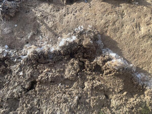
Freeze-thaw cycles can contribute to bank erosion. When ice crystals form in the soil, as shown here, the expanding ice can break up the otherwise consolidated sediment, and when the ice melts, the loosened soil is more vulnerable to erosion.
Freeze-thaw cycles can contribute to bank erosion. When ice crystals form in the soil, as shown here, the expanding ice can break up the otherwise consolidated sediment, and when the ice melts, the loosened soil is more vulnerable to erosion.
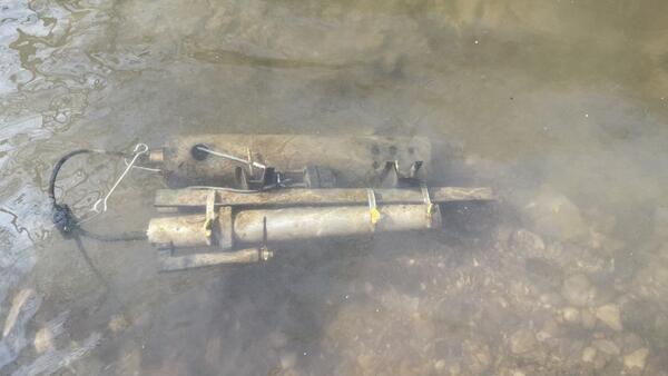
In-situ water quality monitors, also called water quality sondes, are used to collect real-time data on water chemistry.
In-situ water quality monitors, also called water quality sondes, are used to collect real-time data on water chemistry.
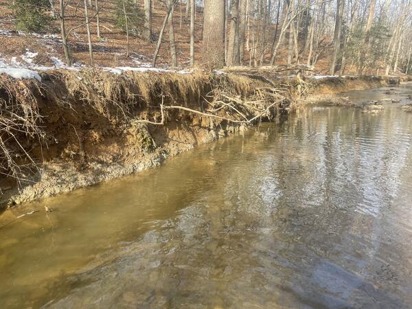
The water quality monitoring site at Little Difficult Run in Fairfax County, Virginia. The banks of this urban stream are eroding, contributing to elevated loads of suspended sediment to downstream water bodies. Little Difficult Run is a part of the Fairfax County Water Resources Monitoring Network.
The water quality monitoring site at Little Difficult Run in Fairfax County, Virginia. The banks of this urban stream are eroding, contributing to elevated loads of suspended sediment to downstream water bodies. Little Difficult Run is a part of the Fairfax County Water Resources Monitoring Network.
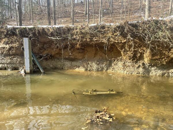
The water quality monitoring site at Little Difficult Run in Fairfax County, Virginia. A staff gage, which is used to measure water depth, is installed on the far bank, and a submerged water quality monitoring sonde is affixed to the streambed. Little Difficult Run is a part of the Fairfax County Water Resources Monitoring Network.
The water quality monitoring site at Little Difficult Run in Fairfax County, Virginia. A staff gage, which is used to measure water depth, is installed on the far bank, and a submerged water quality monitoring sonde is affixed to the streambed. Little Difficult Run is a part of the Fairfax County Water Resources Monitoring Network.

Snakeden Branch is an urban stream in Reston, Virginia that has undergone stream restoration, and is currently being monitored to assess hydrologic and ecosystem health.
Snakeden Branch is an urban stream in Reston, Virginia that has undergone stream restoration, and is currently being monitored to assess hydrologic and ecosystem health.

A night time photograph of a total station used for land surveying used by the National Geodetic Survey.
A night time photograph of a total station used for land surveying used by the National Geodetic Survey.

View downriver from the monitoring station: Roanoke River at Rts 639/760 at Salem, VA - USGS Water Data for the Nation

View upriver from the monitoring station: Roanoke River at Rts 639/760 at Salem, VA - USGS Water Data for the Nation

Photograph of a clay pad used in monitoring sediment deposition. Once installed, the amount of sediment deposited atop the clay pad can be periodically measured. Sediment deposition is monitored along the Long Branch creek in Fairfax County, Virginia as a part of the Fairfax County Water Resources Monitoring Network.
Photograph of a clay pad used in monitoring sediment deposition. Once installed, the amount of sediment deposited atop the clay pad can be periodically measured. Sediment deposition is monitored along the Long Branch creek in Fairfax County, Virginia as a part of the Fairfax County Water Resources Monitoring Network.

A photograph of geodetic surveying at the Fort McHenry National Monument and Historic Site (National Park Service).
A photograph of geodetic surveying at the Fort McHenry National Monument and Historic Site (National Park Service).

Photo Contest Winner | September 2021 | Honorable Mention 1
Kenna Grubb measuring on the Holston River
Photo Contest Winner | September 2021 | Honorable Mention 1
Kenna Grubb measuring on the Holston River

A photograph of a total station used for land surveying.
A photograph of a total station used for land surveying.

This photograph shows a high-accuracy geodetic surveying tripod used to measure vertical land motion.
This photograph shows a high-accuracy geodetic surveying tripod used to measure vertical land motion.

Collecting raw-water samples from a public water supply system pump house. Raw water is the natural water (e.g., groundwater and surface water) that has not yet been treated for human consumption.
Collecting raw-water samples from a public water supply system pump house. Raw water is the natural water (e.g., groundwater and surface water) that has not yet been treated for human consumption.

Equipment used for water-quality sampling needs thoroughly cleaned to remove lingering contaminants or sediment. In this photo, a peristaltic pump is used to flush three different solutions (liquid detergent, tap water, and deionized water) through the tubing used to collect raw-water samples from the public water supply systems.
Equipment used for water-quality sampling needs thoroughly cleaned to remove lingering contaminants or sediment. In this photo, a peristaltic pump is used to flush three different solutions (liquid detergent, tap water, and deionized water) through the tubing used to collect raw-water samples from the public water supply systems.

Collecting raw-water samples from a public water supply system pump house. Water is drawn into a sampling chamber (left) to prevent external contamination of the water. A sonde connected to a handheld display (right) records ancillary parameters like pH, temperature, and dissolved oxygen.
Collecting raw-water samples from a public water supply system pump house. Water is drawn into a sampling chamber (left) to prevent external contamination of the water. A sonde connected to a handheld display (right) records ancillary parameters like pH, temperature, and dissolved oxygen.

This scenic view of Howards Creek was observed in White Sulphur Springs, a city in Greenbriar County in southeastern West Virginia.
This scenic view of Howards Creek was observed in White Sulphur Springs, a city in Greenbriar County in southeastern West Virginia.

A photograph of a National Geodetic Survey (NOAA) continuous monitoring benchmark.
A photograph of a National Geodetic Survey (NOAA) continuous monitoring benchmark.

Demonstration of how to add ice packs to shipping boxes for proper sample shipping.
Demonstration of how to add ice packs to shipping boxes for proper sample shipping.

Two Rosyside dace (Clinostomus funduloides) caught during a USGS fish survey in Reston, Virginia.
Two Rosyside dace (Clinostomus funduloides) caught during a USGS fish survey in Reston, Virginia.