
Volcano Science Center
Find U.S. Volcano
The Volcano Science Center is the primary center serving the mission of the USGS Volcano Hazards Program — to enhance public safety and minimize social and economic disruption from volcanic unrest and eruption. The center is home to the five US volcano observatories with offices in Anchorage, Alaska; Menlo Park and Mountain View, California; Vancouver, Washington; and Hilo, Hawaii.


News
No longer in the dark: Shining a light on Yellowstone’s hydrothermal explosions
No longer in the dark: Shining a light on Yellowstone’s hydrothermal explosions
Volcano Watch — Fountains and festivities: Kīlauea erupts episode 44 as Merrie Monarch begins
Volcano Watch — Fountains and festivities: Kīlauea erupts episode 44 as Merrie Monarch begins
The 2024 YVO annual report has just exploded from the presses!
The 2024 YVO annual report has just exploded from the presses!
Publications
Cenozoic distributed volcanism of the Arabia Plate—A review Cenozoic distributed volcanism of the Arabia Plate—A review
Cenozoic volcanic rocks of the Arabia Plate cover about 140,000 square kilometers across a distance of about 3,000 kilometers from southern Yemen to southeastern Turkey. The majority of volcanic products are alkali basalts that erupted in restricted areas, commonly over periods of a million or more years, building mafic lava fields, each known in Arabic as a “harrat.” Harrat volcanism...
Mount Rainier volcanic hazard information Mount Rainier volcanic hazard information
Introduction Eruptions at Mount Rainier produce lava flows, plumes of airborne volcanic ash, and avalanches of hot rock, ash, and gas—pyroclastic flows—that rush down the steep, ice-covered slopes of the volcano. Hot rock and ash ejected during an eruption can melt large quantities of snow and ice, forming huge, fast moving mudflows called lahars that travel 30+ miles, all the way to...
Yellowstone Volcano Observatory 2024 annual report Yellowstone Volcano Observatory 2024 annual report
The Yellowstone Volcano Observatory (YVO) monitors volcanic and hydrothermal activity associated with the Yellowstone magmatic system, carries out research into magmatic processes occurring beneath Yellowstone Caldera, and issues timely warnings and guidance related to potential future geologic hazards. YVO is a collaborative consortium that includes the U.S. Geological Survey (USGS)...
Science
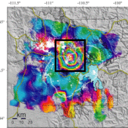
Uplift along the north rim of Yellowstone Caldera
An area on the north rim of Yellowstone caldera, to the south of Norris Geyser Basin, started to uplift slightly in July 2025. Similar deformation occurred in the same area during 1996-2004 and reveals characteristics of the subsurface.
USGS volcano-hydrothermal fluid chemistry data
The USGS has published chemistry data for volcanic and hydrothermal fluids sampled at sites around the United States.

How are lava flows mapped in Hawaii?
Lava flow mapping provides situational awareness of volcanic eruptive hazards in Hawaii. During eruptions, USGS Hawaiian Volcano Observatory (HVO) scientists employ a variety of techniques to collect and disseminate map data depicting key eruptive features, especially lava flows.