
Volcano Science Center
Find U.S. Volcano
The Volcano Science Center is the primary center serving the mission of the USGS Volcano Hazards Program — to enhance public safety and minimize social and economic disruption from volcanic unrest and eruption. The center is home to the five US volcano observatories with offices in Anchorage, Alaska; Menlo Park and Mountain View, California; Vancouver, Washington; and Hilo, Hawaii.


News
Volcano Watch — A hui hou to a giant of volcanology
Volcano Watch — A hui hou to a giant of volcanology
Photo & Video Chronology — Kīlauea summit monitoring overflight
Photo & Video Chronology — Kīlauea summit monitoring overflight
Oops, it did it again: Another small hydrothermal explosion at Biscuit Basin
Oops, it did it again: Another small hydrothermal explosion at Biscuit Basin
Publications
Thermal infrared and ultraviolet remote sensing of sulfur dioxide gas emitted during the 2018 lower East Rift Zone eruption of Kilauea, Hawaiʻi Thermal infrared and ultraviolet remote sensing of sulfur dioxide gas emitted during the 2018 lower East Rift Zone eruption of Kilauea, Hawaiʻi
Ultraviolet (UV) remote sensing is widely used to detect volcanic sulfur dioxide (SO₂) due to its high sensitivity and favorable spatial and temporal resolution. However, significant discrepancies have been reported between ground-based and satellite-based UV observations of dense volcanic plumes. A notable example is the 2018 lower East Rift Zone eruption of Kīlauea, where SO₂ emission...
Osmium isotope constraints on Mauna Loa–Kilauea magmatic connectivity, Island of Hawai‘i Osmium isotope constraints on Mauna Loa–Kilauea magmatic connectivity, Island of Hawai‘i
The Hawaiian volcanic chain exhibits a long-recognized double track of volcanism defined by the Loa and Kea trends, which erupt chemically and isotopically distinct lavas. Mauna Loa and Kīlauea, the two most frequently active volcanoes of the Loa and Kea trends, produce distinct endmember compositions. However, historical periods of compositional convergence have prompted debate...
Tephra from Kīlauea’s 2008–2018 lava lake eruption—Proximal deposits and dispersal characteristics Tephra from Kīlauea’s 2008–2018 lava lake eruption—Proximal deposits and dispersal characteristics
A network of ten buckets was established early in the 2008–2018 summit eruption at Kīlauea to collect proximal tephra ejected from the new, informally named the “Overlook crater”; the buckets were emptied on most days of the eruption thereafter. This report summarizes the results of more than 2,400 different sampling intervals (most 1–3 days long) during the eruption, focusing on the...
Science
Uplift along the north rim of Yellowstone Caldera
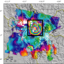
An area on the north rim of Yellowstone caldera, to the south of Norris Geyser Basin, started to uplift slightly in July 2025. Similar deformation occurred in the same area during 1996-2004 and reveals characteristics of the subsurface.
USGS volcano-hydrothermal fluid chemistry data
The USGS has published chemistry data for volcanic and hydrothermal fluids sampled at sites around the United States.

How are lava flows mapped in Hawaii?
Lava flow mapping provides situational awareness of volcanic eruptive hazards in Hawaii. During eruptions, USGS Hawaiian Volcano Observatory (HVO) scientists employ a variety of techniques to collect and disseminate map data depicting key eruptive features, especially lava flows.