U.S. flag

An official website of the United States government

Data

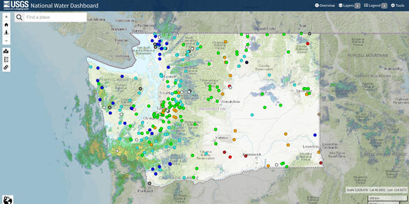
The USGS Washington Water Science Center currently operates over 380 data-collection sites in Washington.  The sites collect surface water, groundwater, water quality and meteorological data that are available in real time.  Current and historical data can be retrieved from Water Data for the Nation and the National Water Dashboard.

Separately published data releases are listed below.

Filter Total Items: 116

Influence of urbanization on the health of juvenile salmonids in Pacific Northwest perennial streams Influence of urbanization on the health of juvenile salmonids in Pacific Northwest perennial streams

Physical and chemical changes affect the biota within urban streams at varying scales ranging from individual organisms to populations and communities creating complex interactions that present challenges for characterizing and monitoring the impact on species utilizing these freshwater habitats. Salmonids, specifically cutthroat trout (Oncorhynchus clarkii) and coho salmon (Oncorhynchus...

Surface-Water for Washington Surface-Water for Washington

Real-time, daily, peak-flow, field measurements, and statistics of current and historical data that describe stream levels, streamflow (discharge), reservoir and lake levels, surface-water quality, and rainfall in Washington. Surface-water data are collected and stored as either discrete field-water-level measurements or as continuous time-series data from automated recorders.

Data for Turbidity, Discharge, and Suspended-Sediment Concentrations and Loads, Duwamish River, Tukwila, Washington Data for Turbidity, Discharge, and Suspended-Sediment Concentrations and Loads, Duwamish River, Tukwila, Washington

This data release includes turbidity, discharge, suspended-sediment concentration (SSC) and particle-size data that were collected by the U.S. Geological Survey (USGS) between February 2013 and January 2017 at the Duwamish River, Washington, within the tidal influence at river kilometer 16.7 (USGS site 12113390; Duwamish River at Golf Course at Tukwila, WA). Additionally included in this...

A Baseline Assessment of Contaminant Concentrations in Sediment and Biota in Proximity to Coal Transport Tracks in the Pacific Northwest (2014) A Baseline Assessment of Contaminant Concentrations in Sediment and Biota in Proximity to Coal Transport Tracks in the Pacific Northwest (2014)

This dataset provides baseline concentrations (from 2014) of polycyclic aromatic hydrocarbon (PAH), other aromatic organic compounds, mercury (Hg), and trace metal concentrations in sediment and biota collected from two sites along an existing rail line used for coal transport in the Columbia River Gorge, Washington. For this study, aquatic surface sediments, aquatic insects, and...

Groundwater data for Washington Groundwater data for Washington

Data from wells, springs, test holes, tunnels, drains, and excavations in Washington; well location data includes information such as latitude and longitude, well depth, and aquifer. Groundwater level data are collected and stored as either discrete field-water-level measurements or as continuous time-series data from automated recorders.

Water-quality data for Washington Water-quality data for Washington

Chemical, physical, and biological properties of water, sediment, and tissue samples from Washington. Water-quality data are collected as either discrete field measurements or as continuous time-series data from automated recorders that continuously record physical and chemical characteristics including pH, specific conductance, temperature, and dissolved oxygen.

Surficial sediment data on the North Fork Stillaguamish River and State Route 530 landslide near Oso, Washington Surficial sediment data on the North Fork Stillaguamish River and State Route 530 landslide near Oso, Washington

These tables document grain-size distributions of sediment collected as part of a study on the geomorphic impacts of the March 2014 State Route 530 Landslide near Oso, Washington. This includes samples of material from the landslide deposit itself, covering a range of distinct facies present in the landslide, and samples of sand and gravel at various locations along the North Fork...

Concentration of nitrate and other water-quality constituents in groundwater from the water table beneath forage fields receiving seasonal applications of dairy manure, Whatcom County, Washington (2015) Concentration of nitrate and other water-quality constituents in groundwater from the water table beneath forage fields receiving seasonal applications of dairy manure, Whatcom County, Washington (2015)

Application of dairy manure to cropland is intended to provide nutrients for crop growth and improve soil quality, the goal being to match the rate of nutrient application to that rate of nutrient removal by the crop. Nitrate contamination of groundwater is widespread and persistent in the shallow surficial aquifer of northwestern Whatcom County where dairy farming and forage production...

Bathymetric Data in the Green River near Tukwila, Washington Bathymetric Data in the Green River near Tukwila, Washington

The U.S. Army Corps of Engineers scheduled repair on parts of an 850-ft long levee located along the Green River near S. 180th St. and Highway 181 downstream of Kent, WA. There is a Muckleshoot Indian Tribe Usual and Accustomed treaty area fishing site immediately downstream from the proposed bank work area and the Tribe is concerned that the levee rehabilitation project may cause...

Water-use data for Washington Water-use data for Washington

Water-use data is collected by area type (state, county, watershed, or aquifer) and source (such as rivers or groundwater), and category (such as public supply or irrigation). Water-use data has been reported every five years since 1985. The USGS works in cooperation with local, State, and Federal agencies as well as academic and private organizations to collect and report withdrawals.

Geospatial database of sampled sites and watershed and riparian characteristics of Puget Sound lowland ecoregion streams sampled for the 2015 Stormwater Action Monitoring status and trends study Geospatial database of sampled sites and watershed and riparian characteristics of Puget Sound lowland ecoregion streams sampled for the 2015 Stormwater Action Monitoring status and trends study

Stormwater Action Monitoring (SAM) is a collaborative monitoring program between western Washington municipal stormwater permittees, state and federal agencies. SAMs role is to use the results of regional monitoring and focused studies to inform policy decisions and identify effective strategies to improve stormwater management in the Puget Sound region. The SAM program includes status...

Accelerometer scour monitor data on the Cedar River, Washington, 2013 - 2014 Accelerometer scour monitor data on the Cedar River, Washington, 2013 - 2014

Accelerometer scour monitors were deployed on the Cedar River, Washington from 2013 to 2014 as part of a study on the timing of streambed scour at 73 locations in salmon-spawning habitat. This data release contains data of the three-dimensional orientation recorded at 20- to 30-minute intervals for the 46 accelerometer monitors that were recovered in 2014. Each accelerometer scour...
Was this page helpful?