U.S. flag

An official website of the United States government

Data

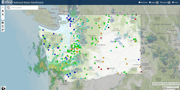
The USGS Washington Water Science Center currently operates over 380 data-collection sites in Washington.  The sites collect surface water, groundwater, water quality and meteorological data that are available in real time.  Current and historical data can be retrieved from Water Data for the Nation and the National Water Dashboard.

Separately published data releases are listed below.

Filter Total Items: 121

Hydrograph Separation of Selected Continuous Discharge Sites in the Colombia Plateau Region of the Pacific Northwest Hydrograph Separation of Selected Continuous Discharge Sites in the Colombia Plateau Region of the Pacific Northwest

This data release contains the results from hydrograph separation analysis for 44 separate sites within the Columbia Plateau region of the Pacific Northwest. The hydrograph separation program (HYSEP) (Sloto and Crouse, 1996) was used to perform baseflow separation. HYSEP is an automated approach to traditional graphical hydrograph separation methods and was utilized for this study. For...

Data in support of groundwater- and surface-water-interactions report—Groundwater and Surface-Water Interactions in the Lower Duwamish Waterway, Seattle, Washington Data in support of groundwater- and surface-water-interactions report—Groundwater and Surface-Water Interactions in the Lower Duwamish Waterway, Seattle, Washington

The U.S. Geological Survey (USGS), in cooperation with the Washington State Department of Ecology (Ecology), conducted a study to describe the current understanding of the regional groundwater system of the lower Duwamish River valley and groundwater and surface-water interactions in the lower Duwamish Waterway. A nearshore site along the western shoreline of the Duwamish River, about 1...

Bathymetric Surveys of the White River at the U.S. Army Corps of Engineers Fish Passage Facility, December 2020 to September 2022 Bathymetric Surveys of the White River at the U.S. Army Corps of Engineers Fish Passage Facility, December 2020 to September 2022

The U.S. Army Corps of Engineers Fish Passage Facility, located on the White River, Washington State, collects upstream-migrating fish and transfers them to trucks, allowing the fish to access the watershed upstream of Mud Mountain Dam. The structure, constructed in 2019, includes an impoundment held by gates that can be raised or lowered remotely. Those gates are typically lowered...

Spatial Data in Support of the Characterization of Water Resources near the Southeastern Part of Puget Sound, Washington Spatial Data in Support of the Characterization of Water Resources near the Southeastern Part of Puget Sound, Washington

The data within this data release presents information used to characterize the groundwater-flow system and the development of a groundwater-flow model in the active model area. Conceptual and numerical models of groundwater flow were developed by the U.S. Geological Survey Washington Water Science Center, in close cooperation with 18 water-resource agencies and stakeholders, to assess...

Stream Temperature Models of White River Watershed, Mount Rainier National Park, Washington Stream Temperature Models of White River Watershed, Mount Rainier National Park, Washington

Water temperature is an important characteristic of stream conditions with implications for water quality and stream dwelling organisms. This Data Release contains spatial stream network (SSN) objects and R scripts to run SSN models to predict mean monthly stream temperature and 7-day average daily maximum (Max7DAD) during August and September in the White River watershed within Mount...

Water stargrass biomass, stream metabolism estimates, and nutrient data quality control data for the lower Yakima River: June 2018 through September 2020 (ver. 2.0, August 2025) Water stargrass biomass, stream metabolism estimates, and nutrient data quality control data for the lower Yakima River: June 2018 through September 2020 (ver. 2.0, August 2025)

This dataset provides information collected at three stream monitoring sites on the lower Yakima River in Washington State from June 2018 through September 2020 by the U.S. Geological Survey. Sample locations included the Yakima River at Prosser, WA (USGS Station, 12509489), the Yakima River at Kiona, WA (USGS Station, 12510500), and the Yakima River at Van Giesen bridge near Richland...

Water Temperature Dynamics in the Quillayute River Basin, Washington, 2021 - 2023 (ver. 2.0, February 2025) Water Temperature Dynamics in the Quillayute River Basin, Washington, 2021 - 2023 (ver. 2.0, February 2025)

The Quillayute River Basin in northwestern Washington consists of the Quillayute River and the river systems of its major tributaries, the Dickey, Sol Duc, and Bogachiel Rivers. With a drainage area of 629 square miles, the Quillayute River Basin provides important habitat for 23 distinct runs of anadromous steelhead and salmon, representing one of the largest and most productive...

Channel Cross Sections of the Nooksack River near North Cedarville, WA, 2017-2021 Channel Cross Sections of the Nooksack River near North Cedarville, WA, 2017-2021

This data release contains channel cross sections of the Nooksack River near North Cedarville, WA, collected during routine streamgaging and discharge measurement efforts at USGS streamgage 12210700. All cross sections were collected using an acoustic doppler current profiler (ADCP) from the downstream side of the Highway 542 bridge. Raw ADCP measurement data were processed using a...

MODPATH model to simulate particle transport in groundwater near Puget Sound, Pierce County, Washington MODPATH model to simulate particle transport in groundwater near Puget Sound, Pierce County, Washington

MODPATH simulations were performed using the MODFLOW groundwater flow model by Wright and others (2023) as the basis, with particles originating from 5 separate areas in or near Joint Base Lewis-McChord (JBLM). Steady-state and transient runs were performed, with transient runs representing 2005-2015 conditions. This data release contains the input and output files for the simulations...

GIS data for U.S. Geological Survey OFR 2005-1252, The Geologic Map of Seattle—A Progress Report GIS data for U.S. Geological Survey OFR 2005-1252, The Geologic Map of Seattle—A Progress Report

This data release contains the GIS data supporting U.S. Geological Survey Open-File Report (OFR) 2005-1252, "The Geologic Map of Seattle—A Progress Report," published in 2005 by Kathy Goetz Troost, Derek B. Booth, Aaron P. Wisher, and Scott A. Shimel (https://doi.org/10.3133/ofr20051252). The OFR was prepared for the 2005 Washington Hydrogeology Symposium and describes the status of...

Stream heat budget model input and scripts for simulating groundwater and thermal equilibrium controls on annual paired air-water temperature signal transport in headwater streams Stream heat budget model input and scripts for simulating groundwater and thermal equilibrium controls on annual paired air-water temperature signal transport in headwater streams

We investigated the relative importance of groundwater (GW) and other local heat budget processes on downstream annual stream temperature signal characteristics using deterministic heat budget model (HFLUX) scenarios within an idealized stream reach representative of mountainous forested conditions. The purpose of this data release is to provide additional supplemental information for a...

High and average water table estimates for Clover Creek watershed, Pierce County, Washington High and average water table estimates for Clover Creek watershed, Pierce County, Washington

The depths to a high and average water table below the land surface were estimated across the Clover Creek watershed in Pierce County, Washington. Groundwater model simulations provided initial estimates of water-table depths for the analysis. To provide optimized, data-driven estimates of these depths, a continuous bias correction surface was applied to model output according to...
Was this page helpful?