U.S. flag

An official website of the United States government

Images

Search here for some of our available images.

Filter Total Items: 318
Two people in the water with a net near a boat.
Brian Ekstrom and Lance Downing pulling the beach seine to collect juvenile fish at a restoration site on the lower Columbia River

Brian Ekstrom and Lance Downing of USGS are pulling a beach seine to collect juvenile fish for monitoring at a restoration site on the lower Columbia River. The restoration site was created with dredge material in October of 2020 and USGS is monitoring juvenile salmon use, community assemblage, and predator presence.

Four nets submerged in a stream to capture drifting invertebrates

Sampling drifting invertebrates from a stream in the North Cascades of Washington State. We perform drift sampling to determine the invertebrate prey quality and quantity available for drift feeding fish. Data gathered from this sampling are used in bioenergetics modeling, a method of estimating fish growth potential.

Sampling drifting invertebrates from a stream in the North Cascades of Washington State. We perform drift sampling to determine the invertebrate prey quality and quantity available for drift feeding fish. Data gathered from this sampling are used in bioenergetics modeling, a method of estimating fish growth potential.

Cape Alava Sunset
Cape Alava sunset
Cape Alava sunset
Cape Alava sunset

Picture of Cape Alava at sunset.  Cape Alava is a point of land on the outer coast of the Olympic Peninsula. The cape is situated within Olympic National Park, and the Makah Indian Reservation.

Picture of Cape Alava at sunset.  Cape Alava is a point of land on the outer coast of the Olympic Peninsula. The cape is situated within Olympic National Park, and the Makah Indian Reservation.

Surgically implanting transmitters into juvenile Chinook salmon
USGS scientist surgically implanting transmitters into juvenile Chinook salmon on the Shasta River, CA

USGS scientists surgically implanting acoustic transmitters into juvenile Chinook salmon on the Shasta River, California.  Study fish are tracked in the Shasta and Klamath Rivers as they migrate to the Pacific Ocean.  Collected data are used to determine fish survival and migration behaviors.

Fish release at the Keller Ferry Marina
Photograph of a fish release at the Keller Ferry Marina
Light at depth measurements Lake Washington
Conducting water quality and light at depth measurements Lake Washington

Photo taken from Magnuson boat launch before conducting water quality and light at depth measurements during Landsat-8 overpass windows on Lake Washington for the U.S. Geological Survey. 

To learn more about this project and other related research you can visit the WFRC Ecology Section website.

Photo taken from Magnuson boat launch before conducting water quality and light at depth measurements during Landsat-8 overpass windows on Lake Washington for the U.S. Geological Survey. 

To learn more about this project and other related research you can visit the WFRC Ecology Section website.

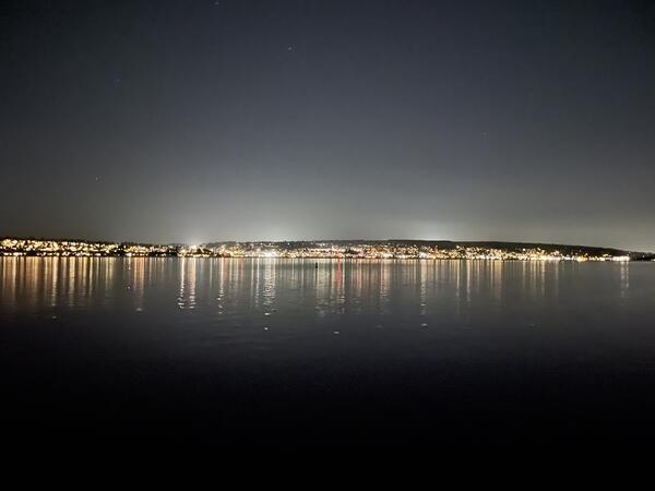
Artificial Light at Night
Lighting from the Kirkland waterfront, viewed from the Seattle shoreline

Lighting from the Kirkland waterfront viewed from the Seattle shoreline.

Photo taken from Magnuson boat launch before conducting a synoptic light survey of Lake Washington for the U.S. Geological Survey.

Lighting from the Kirkland waterfront viewed from the Seattle shoreline.

Photo taken from Magnuson boat launch before conducting a synoptic light survey of Lake Washington for the U.S. Geological Survey.

Artificial Light at Night
Lighting from the Kirkland waterfront, viewed from Seattle shoreline

Photo taken from Magnuson boat launch before conducting a synoptic light survey of Lake Washington for the U.S. Geological Survey.

Image of WFRC Center Director
Center Director, Western Fisheries Research Center

Western Fisheries Research Center, Center Director, Michael Schmidt, spending time with his dog, Echo, doing their version of outdoor activities “in the backyard” during a peak in COVID cases.

Western Fisheries Research Center, Center Director, Michael Schmidt, spending time with his dog, Echo, doing their version of outdoor activities “in the backyard” during a peak in COVID cases.

Researchers performing gastric lavage on a rainbow trout
Researchers perform gastric lavage on a rainbow trout to sample its stomach contents

Researchers perform gastric lavage on a rainbow trout to sample its stomach contents. This fish was sampled as a part of a food web study on Ross and Diablo Lakes in Washington State to evaluate fish growth and limitations to production.

Researchers perform gastric lavage on a rainbow trout to sample its stomach contents. This fish was sampled as a part of a food web study on Ross and Diablo Lakes in Washington State to evaluate fish growth and limitations to production.

Scientist angling on Ross Lake
Scientist angling on Ross Lake as part of food web study

Marshal Hoy, a Biological Science Technician, angling on Ross Lake for Western Fisheries Research Center (WFRC) food web study in October 2021. As a part of this study, fish are sampled for stomach contents, scale samples to assess age and growth, and fin tissue for stable isotopes and genetic analysis.

Marshal Hoy, a Biological Science Technician, angling on Ross Lake for Western Fisheries Research Center (WFRC) food web study in October 2021. As a part of this study, fish are sampled for stomach contents, scale samples to assess age and growth, and fin tissue for stable isotopes and genetic analysis.

USGS boat docked at Ross Lake
USGS boat tied to dock at Ross Lake, Washington in preparation for food web study

USGS boat tied to dock at Ross Lake during a week-long sampling trip for a food web study.  Ross Lake is a large reservoir on the Upper Skagit River in the North Cascade mountains of northern Washington state.

Two USGS researchers wait with their sampling equipment on a boat ramp at Ross Lake.
Scientists staging equipment on dock at Ross Lake, Washington preparing for field work

Researchers stage sampling equipment at the Ross Lake boat ramp and wait for boat to arrive to transport them to camping area. Food web sampling on large lakes requires a substantial amount of sampling gear. Ross Lake is a large reservoir in the North Cascade mountains of northern Washington state.

Researchers stage sampling equipment at the Ross Lake boat ramp and wait for boat to arrive to transport them to camping area. Food web sampling on large lakes requires a substantial amount of sampling gear. Ross Lake is a large reservoir in the North Cascade mountains of northern Washington state.

Scenic view of Ross Lake, Washington

Ross Lake is a large reservoir in the North Cascade mountains of northern Washington state.  This photo was taken while conducting food web research to support the Skagit River Hydroelectric Dam FERC relicensing process. To learn more about this project and other related research you can visit the WFRC Ecology Section website. 

Ross Lake is a large reservoir in the North Cascade mountains of northern Washington state.  This photo was taken while conducting food web research to support the Skagit River Hydroelectric Dam FERC relicensing process. To learn more about this project and other related research you can visit the WFRC Ecology Section website. 

Scientist working on White Salmon River screw trap

USGS scientist, Jill Hardiman, working on a screw trap on the White Salmon River to assess anadromous fish recolonization following removal of a large dam.

White River spinedace

White River spinedace. Photo taken Wayne E. Kirch Wildlife Management Area, Lund, NV.

White River spinedace. Photo taken Wayne E. Kirch Wildlife Management Area, Lund, NV.

USGS PIT detection antenna, Flag Springs Complex, eastern Nevada
USGS passive integrated transponder (PIT) detection antenna

Passive integrated transponder detection antenna located in the Flag Springs Complex in eastern Nevada. This is the only place on earth where White River spinedace still exist.

White River spinedace

White River spinedace. Photo taken by Summer Burdick, USGS, Klamath Falls Field Station.

White River spinedace. Photo taken by Summer Burdick, USGS, Klamath Falls Field Station.

White River desert sucker

White River desert sucker. Photo taken Wayne E. Kirch Wildlife Management Area, Lund, NV.

White River desert sucker. Photo taken Wayne E. Kirch Wildlife Management Area, Lund, NV.

White River spinedace

White River spinedace. Photo taken Wayne E. Kirch Wildlife Management Area, Lund, NV.

White River spinedace. Photo taken Wayne E. Kirch Wildlife Management Area, Lund, NV.

Researcher holding a crayfish collected in Diablo Lake

A native crayfish collected in Diablo Lake for an investigation into food availability for native fish and limitations to their growth. Crayfish are invertebrate prey for salmonids and provide useful representative stable isotope values for benthic members of the food web.

A native crayfish collected in Diablo Lake for an investigation into food availability for native fish and limitations to their growth. Crayfish are invertebrate prey for salmonids and provide useful representative stable isotope values for benthic members of the food web.

Was this page helpful?