
This is an image of a scientist holding a Pinto Abalone. Pinto abalone, once a familiar presence in Washington’s coastal ecosystems, have suffered a decline since.
Images
Search here for some of our available images.
Filter Total Items: 310
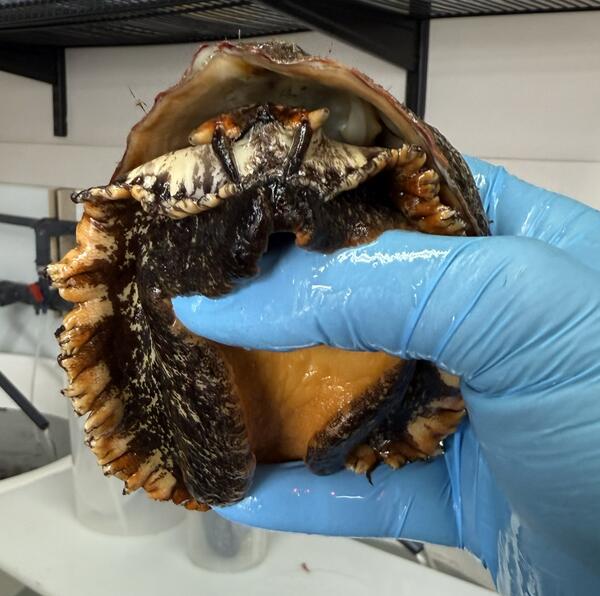
Scientists Holding Pinto Abalone
This is an image of a scientist holding a Pinto Abalone. Pinto abalone, once a familiar presence in Washington’s coastal ecosystems, have suffered a decline since.
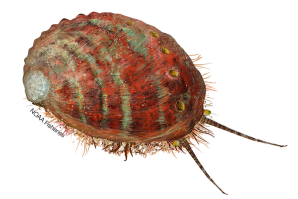
Pinto Abalone Illustration (NOAA)
This is an illustration of a Pinto abalone.
This is an illustration of a Pinto abalone.
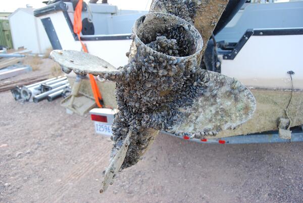
Boat with Invasive Mussel Infestation
This is an image of a boat propeller with an invasive mussel infestation.
This is an image of a boat propeller with an invasive mussel infestation.
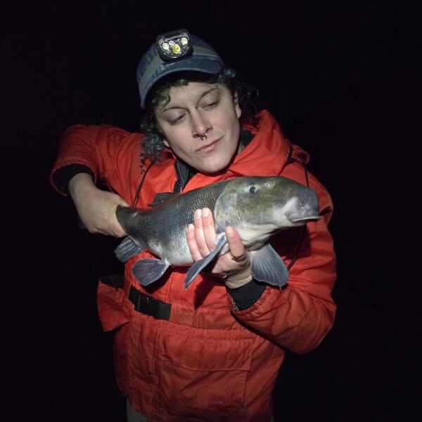
Scientist Holding a Lost River Sucker Fish
This is a photo of scientist, Ramona Rapp, holding a Lost River Sucker that was tagged in Klamath Falls, OR.
This is a photo of scientist, Ramona Rapp, holding a Lost River Sucker that was tagged in Klamath Falls, OR.
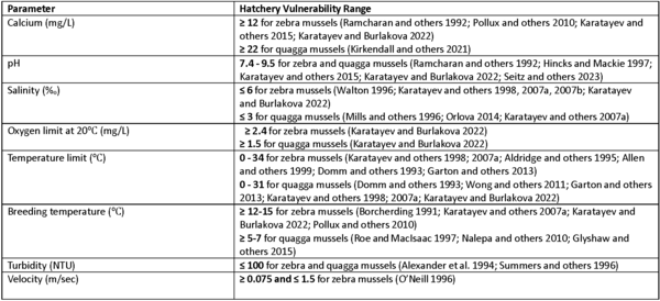
Invasive Mussel Parameters for Hatchery Vulnerability
Invasive Mussel Parameters for Hatchery VulnerabilityHatchery vulnerability range for key zebra mussel (Dreissena polumorpha) and quagga mussel (Dreissena rostriformis bugensis) parameters. If your hatchery is within range of all the vulnerability parameters for a given organism, it is at risk for settlement.
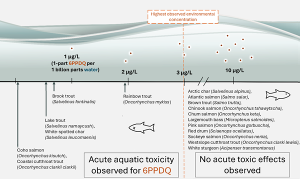
6PPDQ Toxicity in Fish
This is an infographic detailing 6PPDQ toxicity levels in different fish species.
This is an infographic detailing 6PPDQ toxicity levels in different fish species.
Boat on Salmon River
This photo is from USGS Western Fisheries Research Center’s field work on the lower Salmon River this past Fall. Partnering with the Nez Perce Tribe, Rhodes and his team were counting the number of fall Chinook salmon nests, known as redds, with a drone piloted from a jet boat.
This photo is from USGS Western Fisheries Research Center’s field work on the lower Salmon River this past Fall. Partnering with the Nez Perce Tribe, Rhodes and his team were counting the number of fall Chinook salmon nests, known as redds, with a drone piloted from a jet boat.
USGS Fisheries Scientists in Skagit County, WA
These are two USGS Western Fisheries Research Center scientists, Carl Ostberg and Jeff Duda (from left to right), sitting on a fallen tree in Skagit, WA. These scientists study critical fish, like salmon, in the Ross Dam reservoir and tributaries.
These are two USGS Western Fisheries Research Center scientists, Carl Ostberg and Jeff Duda (from left to right), sitting on a fallen tree in Skagit, WA. These scientists study critical fish, like salmon, in the Ross Dam reservoir and tributaries.
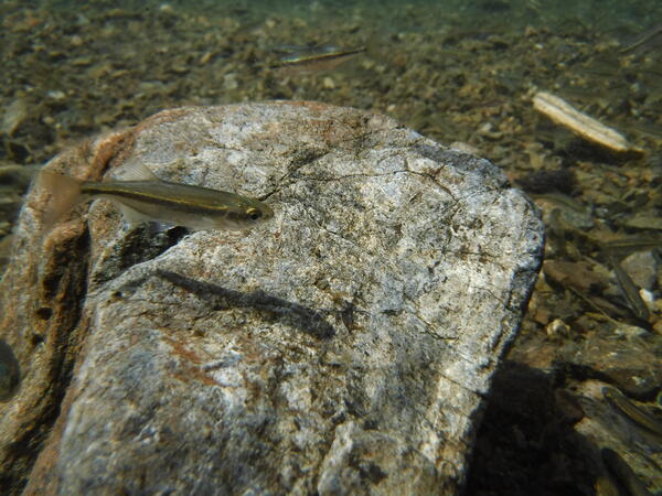
Redside Shiner Fish in Ross Lake, WA
This is a photo of a fish in Ross Lake, WA called the Redside Shiner. Ecologists at the Western Fisheries Research Center are studying this fish and the food web in Ross Lake.
This is a photo of a fish in Ross Lake, WA called the Redside Shiner. Ecologists at the Western Fisheries Research Center are studying this fish and the food web in Ross Lake.
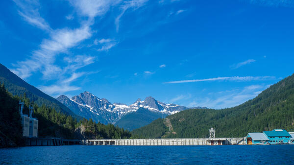
Ross Dam in Skagit, WA
This is a photo of Ross Dam as viewed from the boat. This photo was taken by fisheries scientists from the USGS Western Fisheries Research Center.
This is a photo of Ross Dam as viewed from the boat. This photo was taken by fisheries scientists from the USGS Western Fisheries Research Center.
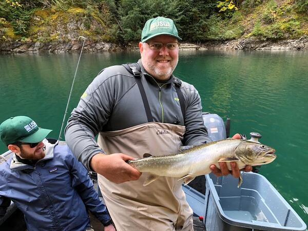
USGS Scientist Holding a Bull Trout in Ross Lake, WA
USGS Scientist Holding a Bull Trout in Ross Lake, WAThis is a photo of scientist, Marshal Hoy, holding a bull trout in Ross Lake. The USGS Western Fisheries Research Center does food web studies in Ross Lake to better understand the ecology and habitat for salmon in the area.
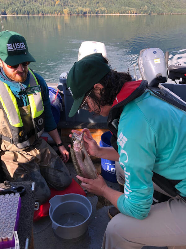
USGS Scientists Collecting Tissue Samples from a Rainbow Trout on Ross Lake.
USGS Scientists Collecting Tissue Samples from a Rainbow Trout on Ross Lake.This is a photo of scientists, Ben Jensen and Shelley Johnson, collecting tissue samples from a rainbow trout on Ross Lake. The USGS Western Fisheries Research Center does work on Ross Lake to understand the food web and ecology for salmon.
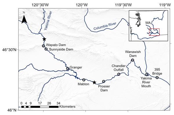
Lower Yakima River Study Map
This is a map of the lower Yakima River showing locations where acoustic telemetry receivers were deployed (open circles) to detect tagged fish that were released at two sites (stars). This was part of the study titled, "Survival implications of diversion entrainment for out-migrating juvenile Chinook Salmon and steelhead.
This is a map of the lower Yakima River showing locations where acoustic telemetry receivers were deployed (open circles) to detect tagged fish that were released at two sites (stars). This was part of the study titled, "Survival implications of diversion entrainment for out-migrating juvenile Chinook Salmon and steelhead.
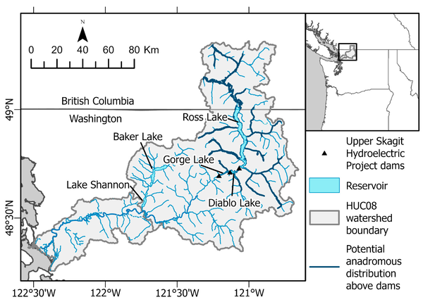
Map of Skagit
Map of the study system. The potential anadromous distribution above the dams indicated is based only on potential physical access to those stream segments (i.e., no migration barriers). Further details and habitat quality results from intrinsic potential modeling can be found in Duda and Hardiman.
Map of the study system. The potential anadromous distribution above the dams indicated is based only on potential physical access to those stream segments (i.e., no migration barriers). Further details and habitat quality results from intrinsic potential modeling can be found in Duda and Hardiman.
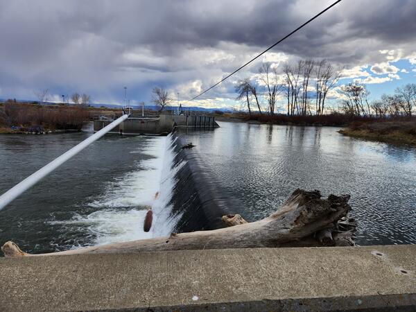
Dam in the lower Yakima River
This is a photo of a dam in the lower Yakima River. Efforts to ameliorate the negative effects of diversion dams on aquatic species of concern are important in rivers where water withdrawal supports agricultural economies, and they are likely to become increasingly important with impending climate change.
This is a photo of a dam in the lower Yakima River. Efforts to ameliorate the negative effects of diversion dams on aquatic species of concern are important in rivers where water withdrawal supports agricultural economies, and they are likely to become increasingly important with impending climate change.
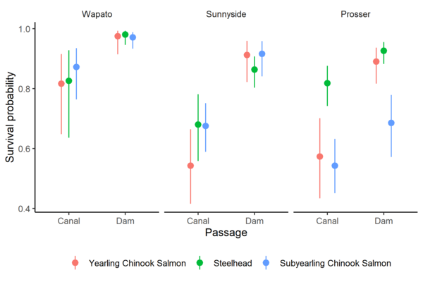
Survival Probabilities of Fish Through Canals Versus Dams
Survival Probabilities of Fish Through Canals Versus DamsSurvival probability estimates and 95% confidence intervals for yearling Chinook Salmon, juvenile steelhead, and subyearling Chinook Salmon at three diversion dams on the Yakima River, Washington.
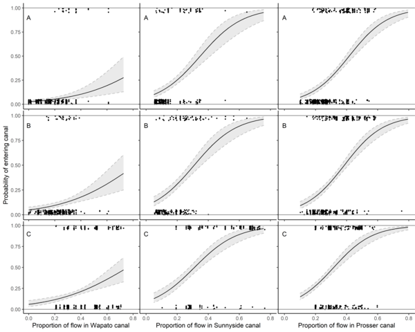
Nine Panel Plot of Fish Passage Entrainment vs Canal Flow
Nine Panel Plot of Fish Passage Entrainment vs Canal FlowEstimated relationship between entrainment probability and proportion of river flow entering canals at Wapato Dam, Sunnyside Dam, and Prosser Dam on the Yakima River, Washington. The relationships are shown at the mean total river flow for (A) yearling Chinook Salmon, (B) juvenile steelhead, and (C) subyearling Chinook Salmon.
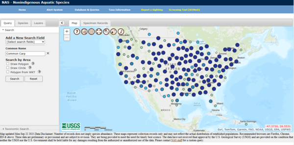
NAS Database
This is a screen grab of the Nonindigenous Aquatic Species Database. This database is used to track the spread of invasive aquatic species across the United States landscape.
This is a screen grab of the Nonindigenous Aquatic Species Database. This database is used to track the spread of invasive aquatic species across the United States landscape.
USGS Researchers Load Boat in Columbia River, OR
Chris Pullano and Ryan Tomka load acoustic telemetry receives on to boat in lower Columbia River estuary. Field work was recently completed for the first year of a study to better understand how young salmon use restored habitats in the Lower Columbia River Estuary.
Chris Pullano and Ryan Tomka load acoustic telemetry receives on to boat in lower Columbia River estuary. Field work was recently completed for the first year of a study to better understand how young salmon use restored habitats in the Lower Columbia River Estuary.
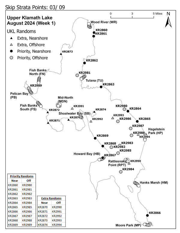
Sucker Nets on Upper Klamath Lake
This is a map of the nets on the Upper Klamath Lake in Oregon. The Western Fisheries Research Center carefully monitors juvenile Sucker populations for signs of population recovery and to better understand where they habitate.
This is a map of the nets on the Upper Klamath Lake in Oregon. The Western Fisheries Research Center carefully monitors juvenile Sucker populations for signs of population recovery and to better understand where they habitate.
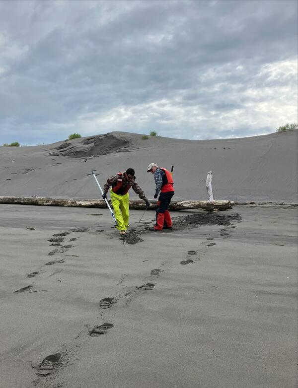
USGS Scientists Unearth Buried Cable Tethering a Telemetry Receiver to Shore in the Columbia River
USGS Scientists Unearth Buried Cable Tethering a Telemetry Receiver to Shore in the Columbia RiverChirs Pullano and Collin Smith unearth the buried cable tethering an acoustic receiver to shore in the lower Columbia River estuary. Shifting sands frequently bury equipment making it difficult to retrieve. During the 2025 field season, researchers deployed acoustic telemetry equipment to track yearling Chinook salmon as they moved through both restored e