



Very-high Resolution Geospatial Ecology (VeRGE) Lab
The Very-high Resolution Geospatial Ecology (VeRGE) Lab at the Western Geographic Science Center specializes in applied remote sensing and landscape ecology. Our research leverages data from drones (a.k.a. small Unoccupied Aerial Vehicles (sUAV)/Unoccupied Aerial Systems (sUAS)) and other high-resolution geospatial sources (ranging from centimeter to meter scale) to address pressing ecological questions.
Title: Very-high Resolution Geospatial Ecology (VeRGE) Lab (IP-193312)
About the VeRGE Lab
The Very-high Resolution Geospatial Ecology (VeRGE) Lab at the Western Geographic Science Center specializes in applied remote sensing and landscape ecology. Our research leverages data from drones (a.k.a. small Unoccupied Aerial Vehicles (sUAV)/Unoccupied Aerial Systems (sUAS)) and other high-resolution geospatial sources (ranging from centimeter to meter scale) to address pressing ecological questions.
Our team investigates a wide variety of topics, including: post-fire mapping and hazards analyses, early detection and mapping of invasive plants, classification of vegetation and soils, landscape and geomorphic change detection, and modeling wildlife micro-habitats.
Our team collects and processes multiple data types including true-color RGB, multispectral, hyperspectral, thermal and lidar, and conducts high precision GPS surveys to ensure spatial accuracy. To analyze these large and complex datasets we use open-source software and develop custom code, ensuring transparency and replication. Our methods often involve advanced image classification, machine learning, and artificial intelligence. USGS High-Performance Computing (HPC) resources are used to efficiently process and interpret landscape-scale, high-resolution image data sets.
We work closely with the USGS National Uncrewed Aerial Systems Office (NUSO) and researchers from other science centers to develop projects that support key missions of Department of Interior and other federal agencies. We also work with university partners, Non-Governmental Organizations (e.g., The Nature Conservancy, Point Blue), and state agencies to support local research and conservation efforts.
A repository of published data and software can be found here (link: WGSC Very-high Resolution Geospatial Ecology Lab - ScienceBase-Catalog) and are also listed in the Data tab.
Science topic TAB: Wildfire and hazards
Wildfires are increasing in size and severity across much of the western United States, often exposing communities in vulnerable wildland-urban interfaces (WUI) to post-fire hazards. After a fire, UAS imagery can provide detailed information about fire’s effects on soil and vegetation that can be collected and measured remotely from safe locations (i.e., roads, clearings), greatly reducing the risk of injury associated with field collections in burned areas. VeRGE lab researchers are collecting and analyzing high resolution data from UAS and aerial lidar data to estimate burn severity and soil erosion potential, and map changes to vegetation, soils and wildlife habitat. The high-resolution data are often used in conjunction with multispectral satellite imagery to estimate impacts across larger burned areas (von Nonn et al., 2024).
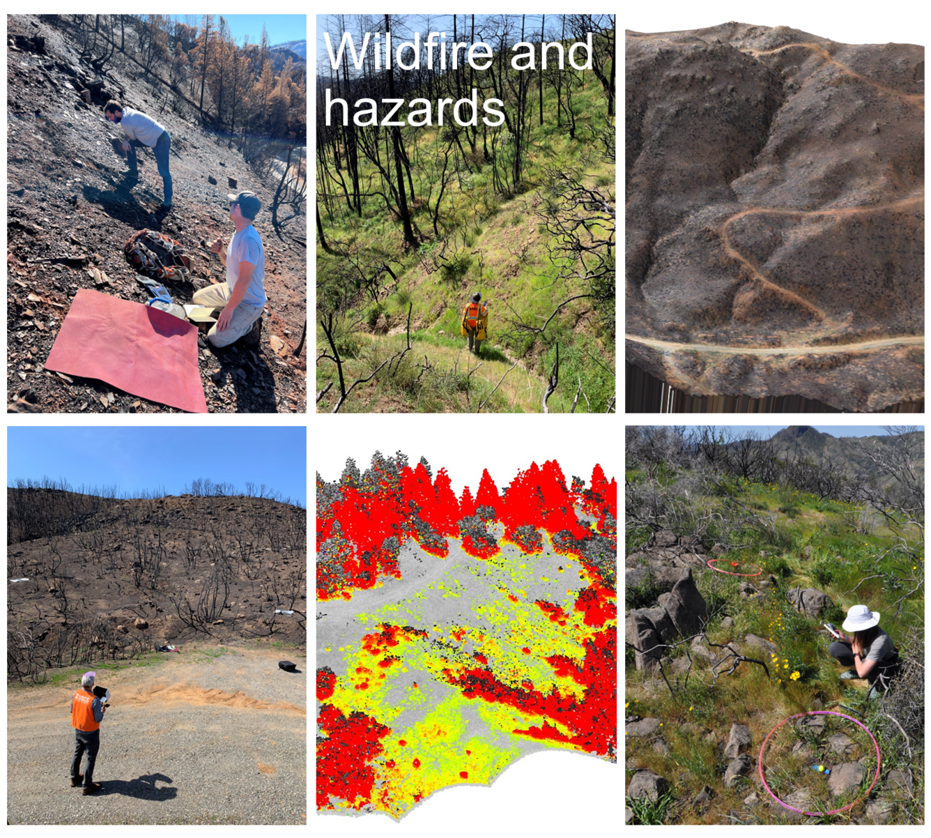
Top row from left to right: USGS scientists collect field measurements of soil water infiltration on a burned slope. USGS scientist traverses a burned slope to set up control points for Aerial Systems (UAS) flights. An orthoimage of a post-fire burned slope. Bottom row from left to right: UAS pilot in burned area. A point-cloud change analysis of forest structure pre- to post-fire (red is where vegetation was lost to fire, grey is no-change, and yellow increase USGS scientist measures vegetation and soils data from within a circular hoop with central maker that is later used to reference plot data with 1-cm scale UAS imagery.
Science topic TAB: Invasive Plant Mapping
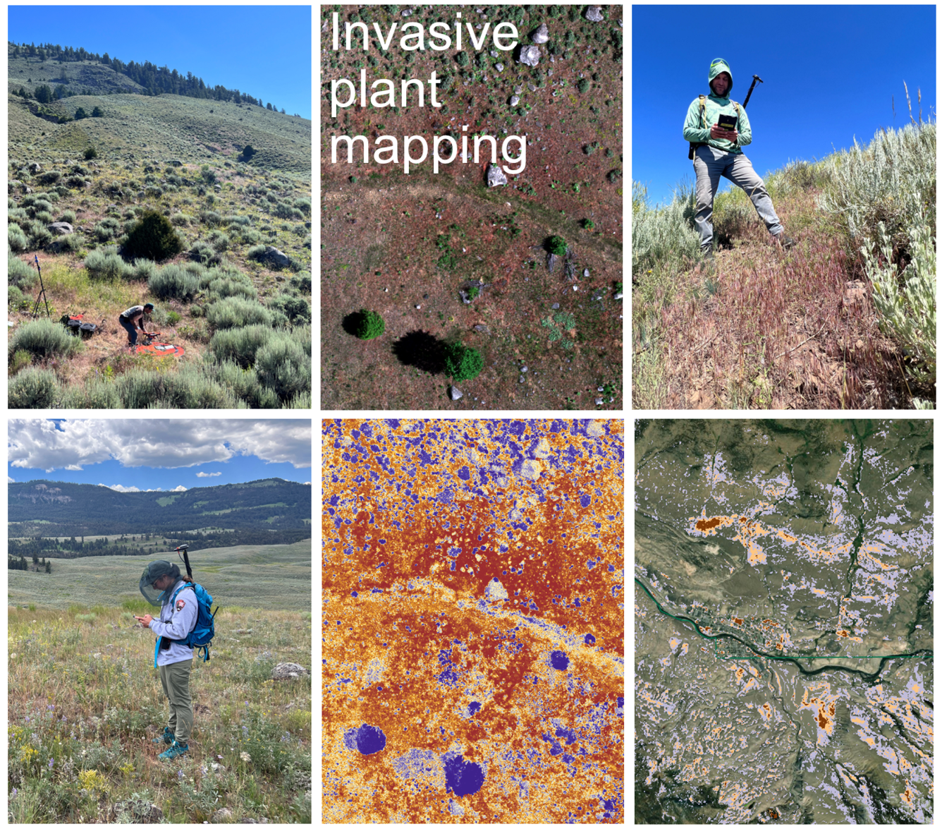
Invasive grasses pose a major threat to many different ecosystems in the western US and can require considerable costs to control and eradicate infestations. To help limit the further advancement of invasive grasses and to guide management actions, we are developing tools and mapping technologies to provide early detection and surveillance of invasive spread. Our work exploits the unique phenology (timing of plant growth and senescence) and spectral characteristics (i.e. color) of invasive grasses compared to native species to map from both drones and satellite data (Kreitler et al. 2025).
Science topic TAB: Drylands and biocrusts
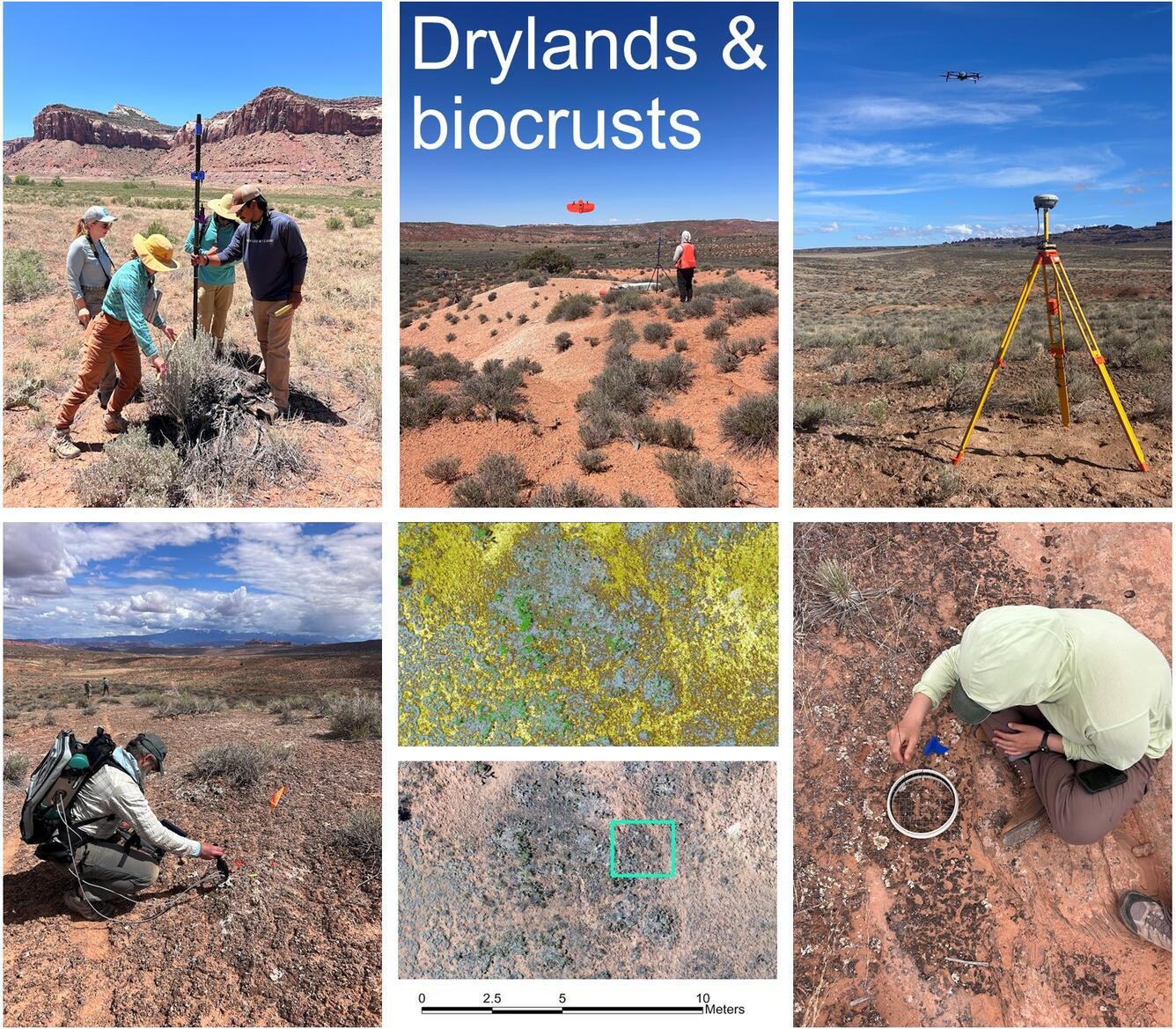
Drylands cover about 40% of the global land surface and support more than one-third of the world’s population, but are increasingly threatened by land degradation and drought. Biological soil crusts (biocrusts) communities of cyanobacteria, lichens, and mosses, are a dominant component of drylands and function to stabilize soils and reduce dust emissions and erosion. VeRGE lab and partners at NUSO have collected natural color, multispectral, hyperspectral, and thermal drone imagery over multiple dryland sites with different vegetation and soils, co-located with field-collected measurements of vegetation and biocrust community composition (Havrilla and Villarreal 2024, Scholl et al. 2025). The field and drone-based images capture fine-scale patterns of individual plant species and biocrust functional types, which are then scaled with various airborne and satellite missions to map fractional cover over large areas enabling us to quantify the impacts of land use change, restoration practices, and drought.
Science topic TAB: Geomorphic change and wetlands
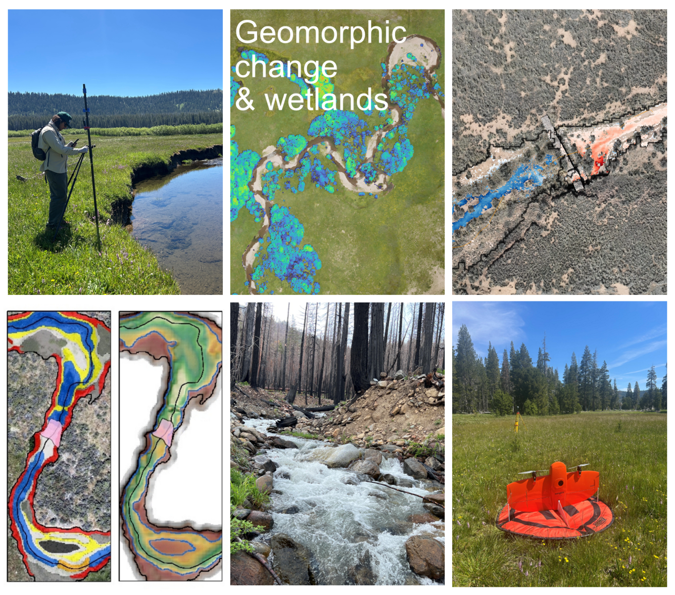
VeRGE lab uses UAS photogrammetry and lidar point clouds to characterize geomorphic changes in incised meadow and dryland stream channels restored with low-tech, process-based treatments. These data are used to calculate pre- and post-restoration Digital Elevation Model (DEM) differencing, generating geomorphic unit classifications and measuring changes in geomorphic complexity over time in response to restoration (LeBeau et al. 2025 ; von Nonn and Sheehy 2026). Multispectral and true-color images are used to map wetland and meadow vegetation to the species and community level, and to evaluate the impacts of restoration treatments and other anthropogenic changes on critical wildlife habitat
Additional TABS on TOP of page
TAB Publications:
Advances and applications of Unoccupied Aerial Systems (UAS) research in landscape ecology
Soil cover heterogeneity associated with biocrusts predicts patch-level plant diversity patterns
Ultra‐high‐resolution mapping of biocrusts with Unmanned Aerial Systems
TAB Data:
DEMs of Difference for selected areas of the Los Planes Watershed, Baja California Sur, Mexico 2024
UAS products and field data for biocrust soil heterogeneity research, Beef Basin, Utah
TAB Science:
Remote Sensing of Invasive Annual Grasses -- Greater Yellowstone Ecosystem
Remote Sensing of Biological Soil Crusts
TAB Software:
UASsbs - Classifying UAS soil burn severity and scaling up to satellite with Python
TAB Multimedia:
The Very-high Resolution Geospatial Ecology (VeRGE) Lab at the Western Geographic Science Center specializes in applied remote sensing and landscape ecology. Our research leverages data from drones (a.k.a. small Unoccupied Aerial Vehicles (sUAV)/Unoccupied Aerial Systems (sUAS)) and other high-resolution geospatial sources (ranging from centimeter to meter scale) to address pressing ecological questions.
Title: Very-high Resolution Geospatial Ecology (VeRGE) Lab (IP-193312)
About the VeRGE Lab
The Very-high Resolution Geospatial Ecology (VeRGE) Lab at the Western Geographic Science Center specializes in applied remote sensing and landscape ecology. Our research leverages data from drones (a.k.a. small Unoccupied Aerial Vehicles (sUAV)/Unoccupied Aerial Systems (sUAS)) and other high-resolution geospatial sources (ranging from centimeter to meter scale) to address pressing ecological questions.
Our team investigates a wide variety of topics, including: post-fire mapping and hazards analyses, early detection and mapping of invasive plants, classification of vegetation and soils, landscape and geomorphic change detection, and modeling wildlife micro-habitats.
Our team collects and processes multiple data types including true-color RGB, multispectral, hyperspectral, thermal and lidar, and conducts high precision GPS surveys to ensure spatial accuracy. To analyze these large and complex datasets we use open-source software and develop custom code, ensuring transparency and replication. Our methods often involve advanced image classification, machine learning, and artificial intelligence. USGS High-Performance Computing (HPC) resources are used to efficiently process and interpret landscape-scale, high-resolution image data sets.
We work closely with the USGS National Uncrewed Aerial Systems Office (NUSO) and researchers from other science centers to develop projects that support key missions of Department of Interior and other federal agencies. We also work with university partners, Non-Governmental Organizations (e.g., The Nature Conservancy, Point Blue), and state agencies to support local research and conservation efforts.
A repository of published data and software can be found here (link: WGSC Very-high Resolution Geospatial Ecology Lab - ScienceBase-Catalog) and are also listed in the Data tab.
Science topic TAB: Wildfire and hazards
Wildfires are increasing in size and severity across much of the western United States, often exposing communities in vulnerable wildland-urban interfaces (WUI) to post-fire hazards. After a fire, UAS imagery can provide detailed information about fire’s effects on soil and vegetation that can be collected and measured remotely from safe locations (i.e., roads, clearings), greatly reducing the risk of injury associated with field collections in burned areas. VeRGE lab researchers are collecting and analyzing high resolution data from UAS and aerial lidar data to estimate burn severity and soil erosion potential, and map changes to vegetation, soils and wildlife habitat. The high-resolution data are often used in conjunction with multispectral satellite imagery to estimate impacts across larger burned areas (von Nonn et al., 2024).
Top row from left to right: USGS scientists collect field measurements of soil water infiltration on a burned slope. USGS scientist traverses a burned slope to set up control points for Aerial Systems (UAS) flights. An orthoimage of a post-fire burned slope. Bottom row from left to right: UAS pilot in burned area. A point-cloud change analysis of forest structure pre- to post-fire (red is where vegetation was lost to fire, grey is no-change, and yellow increase USGS scientist measures vegetation and soils data from within a circular hoop with central maker that is later used to reference plot data with 1-cm scale UAS imagery.
Science topic TAB: Invasive Plant Mapping
Invasive grasses pose a major threat to many different ecosystems in the western US and can require considerable costs to control and eradicate infestations. To help limit the further advancement of invasive grasses and to guide management actions, we are developing tools and mapping technologies to provide early detection and surveillance of invasive spread. Our work exploits the unique phenology (timing of plant growth and senescence) and spectral characteristics (i.e. color) of invasive grasses compared to native species to map from both drones and satellite data (Kreitler et al. 2025).
Science topic TAB: Drylands and biocrusts
Drylands cover about 40% of the global land surface and support more than one-third of the world’s population, but are increasingly threatened by land degradation and drought. Biological soil crusts (biocrusts) communities of cyanobacteria, lichens, and mosses, are a dominant component of drylands and function to stabilize soils and reduce dust emissions and erosion. VeRGE lab and partners at NUSO have collected natural color, multispectral, hyperspectral, and thermal drone imagery over multiple dryland sites with different vegetation and soils, co-located with field-collected measurements of vegetation and biocrust community composition (Havrilla and Villarreal 2024, Scholl et al. 2025). The field and drone-based images capture fine-scale patterns of individual plant species and biocrust functional types, which are then scaled with various airborne and satellite missions to map fractional cover over large areas enabling us to quantify the impacts of land use change, restoration practices, and drought.
Science topic TAB: Geomorphic change and wetlands
VeRGE lab uses UAS photogrammetry and lidar point clouds to characterize geomorphic changes in incised meadow and dryland stream channels restored with low-tech, process-based treatments. These data are used to calculate pre- and post-restoration Digital Elevation Model (DEM) differencing, generating geomorphic unit classifications and measuring changes in geomorphic complexity over time in response to restoration (LeBeau et al. 2025 ; von Nonn and Sheehy 2026). Multispectral and true-color images are used to map wetland and meadow vegetation to the species and community level, and to evaluate the impacts of restoration treatments and other anthropogenic changes on critical wildlife habitat
Additional TABS on TOP of page
TAB Publications:
Advances and applications of Unoccupied Aerial Systems (UAS) research in landscape ecology
Soil cover heterogeneity associated with biocrusts predicts patch-level plant diversity patterns
Ultra‐high‐resolution mapping of biocrusts with Unmanned Aerial Systems
TAB Data:
DEMs of Difference for selected areas of the Los Planes Watershed, Baja California Sur, Mexico 2024
UAS products and field data for biocrust soil heterogeneity research, Beef Basin, Utah
TAB Science:
Remote Sensing of Invasive Annual Grasses -- Greater Yellowstone Ecosystem
Remote Sensing of Biological Soil Crusts
TAB Software:
UASsbs - Classifying UAS soil burn severity and scaling up to satellite with Python
TAB Multimedia: