
Measuring seagrass biomass in Chincoteague Bay, Maryland to constrain numerical models.
Images
Woods Hole Coastal and Marine Science Center images
Filter Total Items: 1298

Measuring seagrass!
Measuring seagrass biomass in Chincoteague Bay, Maryland to constrain numerical models.

Flood tidal shoal
Flood tidal shoal at Barnegat Inlet, New Jersey (courtesy USGS EROS NAIP orthophotography)
Flood tidal shoal at Barnegat Inlet, New Jersey (courtesy USGS EROS NAIP orthophotography)

Collecting Samples in Barnegat Bay
Box-cores provide a relatively undistributed look into the recent past to help better understand the processes contributing to sediment deposition and erosion.
Box-cores provide a relatively undistributed look into the recent past to help better understand the processes contributing to sediment deposition and erosion.

UAS Pilot Training
USGS pilot Sandy Brosnahan and Senate Pro Tempore Marc Pacheco discuss the use of Umanned Aerial Systems (UASs, also known as drones) to collect data in coastal environments. Photo credit: Dann Blackwood, USGS.
USGS pilot Sandy Brosnahan and Senate Pro Tempore Marc Pacheco discuss the use of Umanned Aerial Systems (UASs, also known as drones) to collect data in coastal environments. Photo credit: Dann Blackwood, USGS.

Conceptual diagram used to assess potential sea-level rise impacts
Conceptual diagram used to assess potential sea-level rise impactsConceptual diagram showing the structure of the Bayesian network used to assess potential sea-level rise impacts on the coastal landscape.
Conceptual diagram used to assess potential sea-level rise impacts
Conceptual diagram used to assess potential sea-level rise impactsConceptual diagram showing the structure of the Bayesian network used to assess potential sea-level rise impacts on the coastal landscape.

Decision Making Framework
Problem statement, objectives, and alternative actions defined by Department of Interior collaborators using structured decision making framework
Problem statement, objectives, and alternative actions defined by Department of Interior collaborators using structured decision making framework

Illustration of the NIMBBLE (New instrument for making bottom boun
Illustration of the NIMBBLE (New instrument for making bottom bounIllustration of the NIMBBLE (New instrument for making bottom boundary layer evaluations). The NIMBBLE is a low-profile platform with two acoustic Doppler velocimeters and an upward-looking acoustic Doppler profilers.

Deploying multibeam sonar
USGS staff and the ship's crew of the R/V Sharp prepare to deploy a deep-water multibeam echosounder during a mapping program in the mid-Atlantic in 2015.
USGS staff and the ship's crew of the R/V Sharp prepare to deploy a deep-water multibeam echosounder during a mapping program in the mid-Atlantic in 2015.

Science crew aboard R/V Marcus G. Langseth.
Science crew aboard R/V Marcus G. Langseth. Ray Sliter (Pacific Coastal and Marine Science Center) and Deb Hutchison (Woods Hole Coastal and Marine Science Center) shown at far left.
Science crew aboard R/V Marcus G. Langseth. Ray Sliter (Pacific Coastal and Marine Science Center) and Deb Hutchison (Woods Hole Coastal and Marine Science Center) shown at far left.

Map showing the tracklines and grab sample sites of the 2014 and 2015
Map showing the tracklines and grab sample sites of the 2014 and 2015Map showing the tracklines and grab sample sites of the 2014 and 2015 geophysical surveys offshore of the Delmarva Peninsula.
Map showing the tracklines and grab sample sites of the 2014 and 2015
Map showing the tracklines and grab sample sites of the 2014 and 2015Map showing the tracklines and grab sample sites of the 2014 and 2015 geophysical surveys offshore of the Delmarva Peninsula.

Sea-level rise effects vary in geomorphology and ecology
Sea-level rise effects vary in geomorphology and ecologyThe effects of sea-level rise will vary by differences in the geomorphology and ecology of the landscape. Images show marsh (top left) rocky coast (top right), barrier beach (bottom left), and coastal bluff (bottom right)

Coastal Response Predictions
Map showing extent and coverage of coastal response type predictions; insets display different prediction types and geospatial variability through time. Predictions of coastal response likelihood for the four prediction time steps at Blackwater National Wildlife Refuge, VA.
Map showing extent and coverage of coastal response type predictions; insets display different prediction types and geospatial variability through time. Predictions of coastal response likelihood for the four prediction time steps at Blackwater National Wildlife Refuge, VA.

Map of daily-averaged ocean surface current data
Map of daily-averaged ocean surface current data integrated from multiple IOOS Partner forecast models
Map of daily-averaged ocean surface current data integrated from multiple IOOS Partner forecast models

Measuring index properties on sediment samples
Junbong Jang of the USGS Woods Hole Coastal and Marine Science Center measures index properties on sediment collected during the Indian Government’s National Gas Hydrates Program (NGHP-02) drilling expedition offshore from eastern India in the summer of 2015.
Junbong Jang of the USGS Woods Hole Coastal and Marine Science Center measures index properties on sediment collected during the Indian Government’s National Gas Hydrates Program (NGHP-02) drilling expedition offshore from eastern India in the summer of 2015.

South Atlantic Coast
Vector Shorelines and Associated Shoreline Change Data for the Southeast Atlantic Coast
Vector Shorelines and Associated Shoreline Change Data for the Southeast Atlantic Coast

Hudson Shelf Valley Study Site
Bathymetry and backscatter intensity of the sea floor of the Hudson Shelf Valley location map
Bathymetry and backscatter intensity of the sea floor of the Hudson Shelf Valley location map

North Atlantic Landscape Conservation Cooperative region
North Atlantic Landscape Conservation Cooperative regionCoastal area within the North Atlantic Landscape Conservation Cooperative region for which predictions have been generated.
North Atlantic Landscape Conservation Cooperative region
North Atlantic Landscape Conservation Cooperative regionCoastal area within the North Atlantic Landscape Conservation Cooperative region for which predictions have been generated.
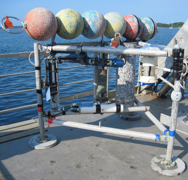
Minipod style tripod for near bottom current and wave measurements
Minipod style tripod for near bottom current and wave measurementsMinipod style tripod for near bottom current and wave measurements ready for deployment.
Minipod style tripod for near bottom current and wave measurements
Minipod style tripod for near bottom current and wave measurementsMinipod style tripod for near bottom current and wave measurements ready for deployment.

Special Delivery
Sandy Brosnahan transporting a weather buoy into the Woods Hole Coastal and Marine Science Center’s operational facility in preparation for deployment. This buoy was one of 6 deployed to measure wind speed, direction, pressure, and temperature off the coast of Fire Island, NY.
Sandy Brosnahan transporting a weather buoy into the Woods Hole Coastal and Marine Science Center’s operational facility in preparation for deployment. This buoy was one of 6 deployed to measure wind speed, direction, pressure, and temperature off the coast of Fire Island, NY.

Juncus Marsh
Photograph of a Juncus marsh in the Tampa Bay estuary, Florida.
Photograph of a Juncus marsh in the Tampa Bay estuary, Florida.

View from Sandwich beach cam
A view from the beach cam on Christmas Day 2015 shows tugs and barges working to install the sand delivery pipe.
A view from the beach cam on Christmas Day 2015 shows tugs and barges working to install the sand delivery pipe.