
A free-drifting sturgeon embryo was captured in the Lower Missouri River in late August. Most sturgeon in the lower Missouri River spawn in the springtime.
Images
Images
Filter Total Items: 9447

Sturgeon Embryo
A free-drifting sturgeon embryo was captured in the Lower Missouri River in late August. Most sturgeon in the lower Missouri River spawn in the springtime.

Wolf River
WOlf River near Landon, MS; Mack Moss measuring overflow during Harricane Issac.
WOlf River near Landon, MS; Mack Moss measuring overflow during Harricane Issac.

Algae near the shoreline in Chesapeake Bay
Algae near the shore of Poplar Island-a 3-mile-long (4.8-kilometer-long) island located on the Chesapeake Bay, part of Talbot County, Maryland.
Algae near the shore of Poplar Island-a 3-mile-long (4.8-kilometer-long) island located on the Chesapeake Bay, part of Talbot County, Maryland.
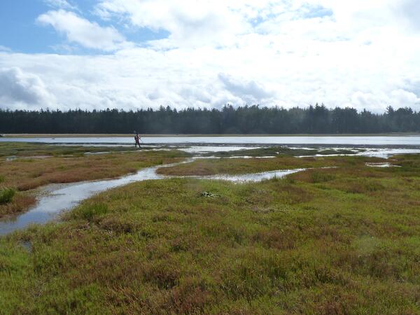
Elevation Field Work at Bandon Marsh
A U.S. Geological Survey technician collects elevation data using a real time kinematic GPS at Bandon National Wildlife Refuge.
A U.S. Geological Survey technician collects elevation data using a real time kinematic GPS at Bandon National Wildlife Refuge.
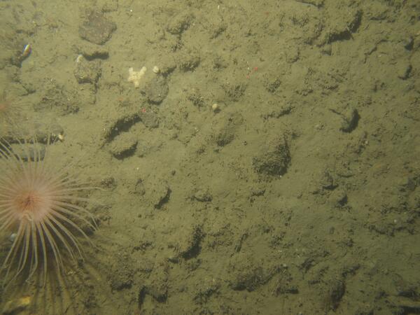
Massachusetts Seafloor
This photograph is of the seafloor off the Massachusetts coast and shows a sea anemone amongst gravel and cobbles. This photograph was collected as part of USGS research in collaboration with the Massachusetts Office of Coastal Zone Management to support development of the Massachusetts Ocean Management Plan and management of the state's waters.
This photograph is of the seafloor off the Massachusetts coast and shows a sea anemone amongst gravel and cobbles. This photograph was collected as part of USGS research in collaboration with the Massachusetts Office of Coastal Zone Management to support development of the Massachusetts Ocean Management Plan and management of the state's waters.
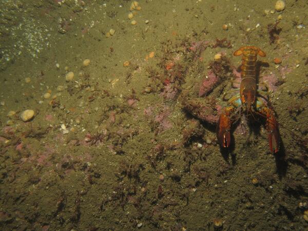
Massachusetts Seafloor
This photograph is of the seafloor off the Massachusetts coast and shows a lobster, sponges and brachiopods on cobbles and ledge covered with seaweed, bubblegum algae and red filamentous algae.
This photograph is of the seafloor off the Massachusetts coast and shows a lobster, sponges and brachiopods on cobbles and ledge covered with seaweed, bubblegum algae and red filamentous algae.
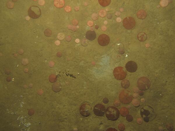
Massachusetts Seafloor
This photograph is of the seafloor off the Massachusetts coast and shows sand dollars and shell fragments on a sandy seabed. This photograph was collected as part of USGS research in collaboration with the Massachusetts Office of Coastal Zone Management to support development of the Massachusetts Ocean Management Plan and management of the state's waters.
This photograph is of the seafloor off the Massachusetts coast and shows sand dollars and shell fragments on a sandy seabed. This photograph was collected as part of USGS research in collaboration with the Massachusetts Office of Coastal Zone Management to support development of the Massachusetts Ocean Management Plan and management of the state's waters.
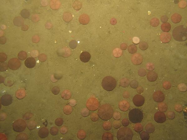
Massachusetts Seafloor
This photograph is of the seafloor off the Massachusetts coast and shows sand dollars and a few shell fragments on a sandy seabed. This photograph was collected as part of USGS research in collaboration with the Massachusetts Office of Coastal Zone Management to support development of the Massachusetts Ocean Management Plan and management of the state's waters.
This photograph is of the seafloor off the Massachusetts coast and shows sand dollars and a few shell fragments on a sandy seabed. This photograph was collected as part of USGS research in collaboration with the Massachusetts Office of Coastal Zone Management to support development of the Massachusetts Ocean Management Plan and management of the state's waters.

Tree Growing over Stream
A tree had fallen into the Marsh River near Shelly, Minnesota, and a new shoot took off right over the river.
A tree had fallen into the Marsh River near Shelly, Minnesota, and a new shoot took off right over the river.
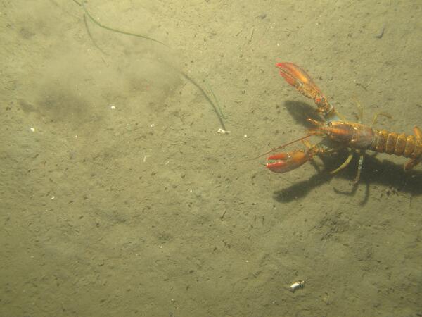
Massachusetts Seafloor
This photograph is of the seafloor off the Massachusetts coast and shows a lobster on a sandy seabed. This photograph was collected as part of USGS research in collaboration with the Massachusetts Office of Coastal Zone Management to support development of the Massachusetts Ocean Management Plan and management of the state's waters.
This photograph is of the seafloor off the Massachusetts coast and shows a lobster on a sandy seabed. This photograph was collected as part of USGS research in collaboration with the Massachusetts Office of Coastal Zone Management to support development of the Massachusetts Ocean Management Plan and management of the state's waters.

Owyhee River
Owyhee River near Rome, OR; Alvin Sablan streamgaging.
Owyhee River near Rome, OR; Alvin Sablan streamgaging.

USGS Scientist Taking Notes in the Field
USGS Geologist Robert Witter documenting tsunami scour features near Stardust Bay, Alaska. Conditions in the Aleutian Islands can be wet and windy for days on end.
Location: Stardust Bay, Sedanka Island, Alaska
USGS Geologist Robert Witter documenting tsunami scour features near Stardust Bay, Alaska. Conditions in the Aleutian Islands can be wet and windy for days on end.
Location: Stardust Bay, Sedanka Island, Alaska

Exposed Tsunami Sand Layers
An outcrop composed of six tsunami deposits on the inland side of the lowland backing Stardust Bay over 0.5 miles from the sea. Brown soils developed into the top of each sand sheet and black tephra (air fall volcanic ash) layers between two of the sand deposits aided correlation of the six sand sheets across the study area.
An outcrop composed of six tsunami deposits on the inland side of the lowland backing Stardust Bay over 0.5 miles from the sea. Brown soils developed into the top of each sand sheet and black tephra (air fall volcanic ash) layers between two of the sand deposits aided correlation of the six sand sheets across the study area.

USGS Scientists Engaged in Field Work on the Aleutian Islands
USGS Scientists Engaged in Field Work on the Aleutian IslandsThree geologists scramble down a hillside on Sedanka Island that overlooks Stardust Bay. The geologists documented driftlogs stranded at elevations up to 60 ft above sea level and over 0.5 mile inland.

Cave in fractured Austin Group rock, Uvalde County
Cave in fractured Austin Group rock, Uvalde CountyCave in fractured Austin Group rock located approximately 9.3 miles northeast of city of Uvalde in Uvalde County, Texas. Photograph taken August 7, 2012, by Robert R. Morris.
SIR 2013–5149
Cave in fractured Austin Group rock, Uvalde County
Cave in fractured Austin Group rock, Uvalde CountyCave in fractured Austin Group rock located approximately 9.3 miles northeast of city of Uvalde in Uvalde County, Texas. Photograph taken August 7, 2012, by Robert R. Morris.
SIR 2013–5149

Prairie dog and SPV bait
In this image, a Gunnison prairie dog eats a bait laden with the sylvatic plague vaccine. Prairie dogs in the wild are less likely to succumb to plague after they ingest peanut-butter-flavored bait that contains a vaccine against the disease.
In this image, a Gunnison prairie dog eats a bait laden with the sylvatic plague vaccine. Prairie dogs in the wild are less likely to succumb to plague after they ingest peanut-butter-flavored bait that contains a vaccine against the disease.

USGS Scientist Taking Notes in the Field, near Prehistoric Drift Log
USGS Scientist Taking Notes in the Field, near Prehistoric Drift LogGeologist takes field notes to document the discovery of a 30-foot long driftlog stranded more than 0.5 mi inland at Stardust Bay on the remote Alaskan island of Sedanka. The log, stranded at an elevation of more than 60 feet above sea level, was carried inland and deposited in 1957 by a large tsunami generated by the magnitude 8.6 Andreanof Islands earthquake.

Sampling Diseased Coral
USGS scientist Thierry Work takes a sample from diseased coral at Tunnels Reef on the north shore of Kauai, Hawaii
USGS scientist Thierry Work takes a sample from diseased coral at Tunnels Reef on the north shore of Kauai, Hawaii

Exposed Tsunami Sand Layers in a Pit Excavated by Scientists
Exposed Tsunami Sand Layers in a Pit Excavated by ScientistsOn a ridge behind Stardust Bay at an elevation of 46 feet above sea level, a shallow pit reveals five sand sheets deposited by tsunamis in the past 1700 years.
Location: Stardust Bay, Sendanka Island, Alaska

Aphanizomenon Flos-aquae Under the Microscope
Aphanizomenon is a common bloom-forming cyanobacteria, AKA, blue-green algae. Many strains produce saxitoxin and cylindrospermopsin.
Aphanizomenon is a common bloom-forming cyanobacteria, AKA, blue-green algae. Many strains produce saxitoxin and cylindrospermopsin.

Western White Pine
A western white pine (Pinus monticola) in Kings Canyon National Park, Calif., towers over USGS ecologist Nathan Stephenson.
A western white pine (Pinus monticola) in Kings Canyon National Park, Calif., towers over USGS ecologist Nathan Stephenson.