A research biologist conducting surgery on a sea lamprey to implant an acoustic telemetry transmitter

Official websites use .gov
A .gov website belongs to an official government organization in the United States.
Secure .gov websites use HTTPS
A lock () or https:// means you’ve safely connected to the .gov website. Share sensitive information only on official, secure websites.
Images

A research biologist conducting surgery on a sea lamprey to implant an acoustic telemetry transmitter
A research biologist conducting surgery on a sea lamprey to implant an acoustic telemetry transmitter

Native westslope cutthroat trout swim in the north fork of the Flathead River in northwestern Montana. This region is recognized as a range-wide stronghold for genetically pure westslope cutthroat trout. However, rainbow trout invasion and hybridization threatens these populations.
Native westslope cutthroat trout swim in the north fork of the Flathead River in northwestern Montana. This region is recognized as a range-wide stronghold for genetically pure westslope cutthroat trout. However, rainbow trout invasion and hybridization threatens these populations.

Native westslope cutthroat trout swim in the north fork of the Flathead River in northwestern Montana. The region is recognized as a range-wide stronghold for genetically pure westslope cutthroat trout. However, rainbow trout invasion and hybridization threatens these populations.
Native westslope cutthroat trout swim in the north fork of the Flathead River in northwestern Montana. The region is recognized as a range-wide stronghold for genetically pure westslope cutthroat trout. However, rainbow trout invasion and hybridization threatens these populations.

Moffett Field, California Aerial Photography and Imagery Library Collection. This photo collection is used by USGS personnel, and the general public. Historical photos from agencies such as Cal-trans, (California Transportation Department) and counties in California are a valuable part of the collection.
Moffett Field, California Aerial Photography and Imagery Library Collection. This photo collection is used by USGS personnel, and the general public. Historical photos from agencies such as Cal-trans, (California Transportation Department) and counties in California are a valuable part of the collection.

Highway 5 between Bottineau and Westhope, North Dakota.
Highway 5 between Bottineau and Westhope, North Dakota.
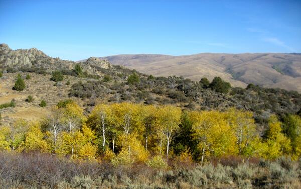
An aspen stand at the Reynolds Creek experimental watershed in Idaho.
An aspen stand at the Reynolds Creek experimental watershed in Idaho.

Southwestern Willow Flycatcher habitat along the Upper Gila River, Arizona.
Southwestern Willow Flycatcher habitat along the Upper Gila River, Arizona.

Former Kanab North uranium mine on the edge of Kanab Creek, north of Grand Canyon.
Former Kanab North uranium mine on the edge of Kanab Creek, north of Grand Canyon.

Geyser cone in the El Tatio geyser field, Chile
Geyser cone in the El Tatio geyser field, Chile

A native bull trout swims in the cool waters of the Flathead River near Glacier National Park, Montana. The tail end of a native Westslope cutthroat trout can be seen below.
A native bull trout swims in the cool waters of the Flathead River near Glacier National Park, Montana. The tail end of a native Westslope cutthroat trout can be seen below.

Native Westslope cutthroat trout and bull trout swim in the cool waters of the Flathead River near Glacier National Park, Montana.
Native Westslope cutthroat trout and bull trout swim in the cool waters of the Flathead River near Glacier National Park, Montana.

A school of native bull trout swims in the cool waters of the Flathead River near Glacier National Park, Montana.
A school of native bull trout swims in the cool waters of the Flathead River near Glacier National Park, Montana.
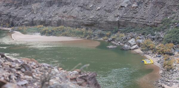
Picture showing the size of the sandbar before the November 2012 controlled flood from the Glen Canyon Dam. This location is 65 miles downstream from Lees Ferry and the view is looking downstream. These and additional photographs depicting the results of the recent controlled floods can be viewed online.
Picture showing the size of the sandbar before the November 2012 controlled flood from the Glen Canyon Dam. This location is 65 miles downstream from Lees Ferry and the view is looking downstream. These and additional photographs depicting the results of the recent controlled floods can be viewed online.

Modified Parshall Flume on Heart River near South Heart, North Dakota. For more information on the use of flumes to aid in the determination of streamflow, see volumes 1 and 2 of the USGS Water Supply Paper, Measurement and Computation of Streamflow.
Modified Parshall Flume on Heart River near South Heart, North Dakota. For more information on the use of flumes to aid in the determination of streamflow, see volumes 1 and 2 of the USGS Water Supply Paper, Measurement and Computation of Streamflow.

Arkansas River at Dardanelle, Arkansas, during low-flow conditions on September 29, 2012. Photograph by Daniel M. Wagner, U.S. Geological Survey.
Arkansas River at Dardanelle, Arkansas, during low-flow conditions on September 29, 2012. Photograph by Daniel M. Wagner, U.S. Geological Survey.

Scientists sample fish in Lake Michigan near Sleeping Bear Dunes National Lakeshore.
Scientists sample fish in Lake Michigan near Sleeping Bear Dunes National Lakeshore.

This Sept. 26, 2012 image from a USGS unmanned aircraft shows the demolition of Glines Dam and Lake Mills on the Elwha River in Olympic National Park, Wash.
This Sept. 26, 2012 image from a USGS unmanned aircraft shows the demolition of Glines Dam and Lake Mills on the Elwha River in Olympic National Park, Wash.

A healthy, banded little brown bat hangs out in a cave. Photo credit: Paul Cryan, USGS.
A healthy, banded little brown bat hangs out in a cave. Photo credit: Paul Cryan, USGS.

Sam Rayburn Lake, September 2012. Photograph by David LaRue, U.S. Army Corps of Engineers.
SIR 2012–5202
Sam Rayburn Lake, September 2012. Photograph by David LaRue, U.S. Army Corps of Engineers.
SIR 2012–5202

Granger Lake, September 2012. Photograph by Ben Bohac, U.S. Army Corps of Engineers.
SIR 2012–5202
Granger Lake, September 2012. Photograph by Ben Bohac, U.S. Army Corps of Engineers.
SIR 2012–5202

An aerial view of coastal marshes along Bayou Dufrene, southwest of the town of Dulac in Louisiana's Terrebonne Basin.
An aerial view of coastal marshes along Bayou Dufrene, southwest of the town of Dulac in Louisiana's Terrebonne Basin.