View of the Little Missouri River at Medora, North Dakota. USGS personnel were their to measure streamflow and maintain the streamgage. Streamflow was 34.8 cubic feet per second, gage height 1.93 feet.

Official websites use .gov
A .gov website belongs to an official government organization in the United States.
Secure .gov websites use HTTPS
A lock () or https:// means you’ve safely connected to the .gov website. Share sensitive information only on official, secure websites.
Images

View of the Little Missouri River at Medora, North Dakota. USGS personnel were their to measure streamflow and maintain the streamgage. Streamflow was 34.8 cubic feet per second, gage height 1.93 feet.
View of the Little Missouri River at Medora, North Dakota. USGS personnel were their to measure streamflow and maintain the streamgage. Streamflow was 34.8 cubic feet per second, gage height 1.93 feet.

Constructed water-control structure connecting a managed pool to Crane Creek wetland (Lake Erie). Structure allows critical fish passage between Lake Erie and the previously diked wetland.
Constructed water-control structure connecting a managed pool to Crane Creek wetland (Lake Erie). Structure allows critical fish passage between Lake Erie and the previously diked wetland.

Picture of the sun over the Arctic Ocean taken from atop the bridge over the bow of the USGC Healy
Picture of the sun over the Arctic Ocean taken from atop the bridge over the bow of the USGC Healy

USGS employee Anthony Lopez enjoys the boat ride back to port after a long day of sampling sediment in the Barnegat Bay near Seaside Heights, NJ.
USGS employee Anthony Lopez enjoys the boat ride back to port after a long day of sampling sediment in the Barnegat Bay near Seaside Heights, NJ.
USGS contractor Phil Owen of EnrGies, Inc. launches a Raven aircraft on the Missouri River near Lower Brule, S.D., during an August 2012 mission to monitor erosion on the river. Owen is accompanied by USGS and Bureau of Indian Affairs researchers.
USGS contractor Phil Owen of EnrGies, Inc. launches a Raven aircraft on the Missouri River near Lower Brule, S.D., during an August 2012 mission to monitor erosion on the river. Owen is accompanied by USGS and Bureau of Indian Affairs researchers.

USGS scientist Jennifer Lewicki measures the discharge along a tributary to Hot Springs Creek, Akutan Island, Alaska. Steam (upper left) rises from 3 high-temperature springs that discharge into the tributary.
USGS scientist Jennifer Lewicki measures the discharge along a tributary to Hot Springs Creek, Akutan Island, Alaska. Steam (upper left) rises from 3 high-temperature springs that discharge into the tributary.

A hot spring discharges 77°C (~171°F) water into Hot Springs Creek, Akutan Island, Alaska.
A hot spring discharges 77°C (~171°F) water into Hot Springs Creek, Akutan Island, Alaska.

USGS scientist Deborah Bergfeld collects a gas sample from a fumarole on the flank of Akutan Volcano, Akutan Island, Alaska.
USGS scientist Deborah Bergfeld collects a gas sample from a fumarole on the flank of Akutan Volcano, Akutan Island, Alaska.

Steam rises from degassing fumaroles (middle right) and a boiling pool (middle left) on the flank of Akutan Volcano, Akutan Island, Alaska.
Steam rises from degassing fumaroles (middle right) and a boiling pool (middle left) on the flank of Akutan Volcano, Akutan Island, Alaska.

NOAA Ship Okeanos Explorer in port after completing EX1205L1.
NOAA Ship Okeanos Explorer in port after completing EX1205L1.

USGS AMBLE coordinator Jenny Chipault inspects a ring-billed gull submitted for avian botulism type E testing. Some sick and dead gulls found on Lake Michigan beaches in 2011 had avian botulism.
USGS AMBLE coordinator Jenny Chipault inspects a ring-billed gull submitted for avian botulism type E testing. Some sick and dead gulls found on Lake Michigan beaches in 2011 had avian botulism.

Photo of the Autonomous Underwater Vehicle (AUV) Sentry being recovered after a dive on the Blake Ridge Diapir.
Photo of the Autonomous Underwater Vehicle (AUV) Sentry being recovered after a dive on the Blake Ridge Diapir.
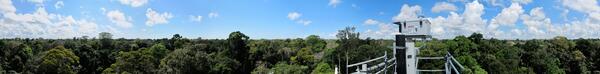
Panorama (360 degree) view from the top of a 148-foot (45-meter) observation tower at the Amazon forest study site near Santarém, Brazil. The instrument on the tower, the USGS High Dynamic Range All-Sky Imaging System (HDR-ASIS), monitors atmospheric conditions and the solar radiation available for photosynthesis.
Panorama (360 degree) view from the top of a 148-foot (45-meter) observation tower at the Amazon forest study site near Santarém, Brazil. The instrument on the tower, the USGS High Dynamic Range All-Sky Imaging System (HDR-ASIS), monitors atmospheric conditions and the solar radiation available for photosynthesis.
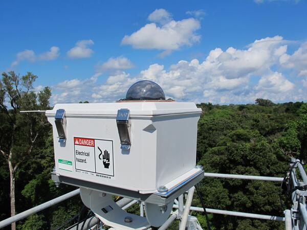
The USGS High Dynamic Range All-Sky Imaging System (HDR-ASIS) is installed on top of a 148-foot (45-meter) observation tower to monitor changes in atmospheric conditions and the solar radiation available for photosynthesis.
The USGS High Dynamic Range All-Sky Imaging System (HDR-ASIS) is installed on top of a 148-foot (45-meter) observation tower to monitor changes in atmospheric conditions and the solar radiation available for photosynthesis.

This image shows a low streamflow on the Arkansas River at Syracuse.
Human activity, such as groundwater pumping, land management, reservoir operations and urbanization, has a measurable effect on streamflows in Kansas locally, regionally and statewide, according to a new USGS report.
This image shows a low streamflow on the Arkansas River at Syracuse.
Human activity, such as groundwater pumping, land management, reservoir operations and urbanization, has a measurable effect on streamflows in Kansas locally, regionally and statewide, according to a new USGS report.

Adult female walruses on ice floe with young.

Adult female walrus on ice floe photographed shortly after receiving a behavior monitoring satellite-linked radio tag from USGS researchers.
Data acquired from such radio-tags are providing insights on the distribution and behavior of Pacific walruses during a time when their summer sea ice habitat is rapidly changing.

Female walruses and their young must haul out of the water to rest between foraging bouts.
Female walruses and their young must haul out of the water to rest between foraging bouts.

Adult female walrus on ice floe.

Equipment used by USGS scientists and partners to collect sediment cores at Basin Bayou in Florida. This is part of research by the USGS and partners to understand past hurricane activity in the Gulf of Mexico and northern Atlantic Ocean. Credit: Jessica Rodysill, USGS.
Equipment used by USGS scientists and partners to collect sediment cores at Basin Bayou in Florida. This is part of research by the USGS and partners to understand past hurricane activity in the Gulf of Mexico and northern Atlantic Ocean. Credit: Jessica Rodysill, USGS.

Adult female walruses on ice floe with young. Notice the radio tag borne on her her upper mid back.
This tag will monitor resting and foraging behavior and convey the information back to USGS scientists.
Adult female walruses on ice floe with young. Notice the radio tag borne on her her upper mid back.
This tag will monitor resting and foraging behavior and convey the information back to USGS scientists.