
USGS Fishery Biologist, Pat Braaten, and biologists from USGS Columbia Environmental Research Center and the Fort Peck Field Office release a telemetry-tagged, female pallid sturgeon after recapturing her to check her reproductive status. She was still full of ripe, black eggs, and had not yet spawned when she was netted.
Images
Images
Filter Total Items: 9447

Pallid Sturgeon Release
USGS Fishery Biologist, Pat Braaten, and biologists from USGS Columbia Environmental Research Center and the Fort Peck Field Office release a telemetry-tagged, female pallid sturgeon after recapturing her to check her reproductive status. She was still full of ripe, black eggs, and had not yet spawned when she was netted.

Preparing Research Boats to Track Tagged Pallid Sturgeon
Preparing Research Boats to Track Tagged Pallid SturgeonBiologist, Dave Combs prepares a tracking boat (foreground) and a DIDSON survey boat (background) to search the Yellowstone River for tagged pallid sturgeon, Near Fairview, Montana. Pallid sturgeon in Montana are tagged with radio telemetry transmitters that are detected with large antennas mounted the boats.
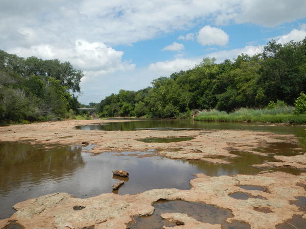
Black Bear Creek
Black Bear Creek upstream from the 4th Street bridge in Pawnee, Oklahoma, 2012.
USGS SIR 2019-5043
Black Bear Creek upstream from the 4th Street bridge in Pawnee, Oklahoma, 2012.
USGS SIR 2019-5043

Water Quality Sampling at Mount Rushmore National Memorial
Water Quality Sampling at Mount Rushmore National MemorialCollection of composite soil samples, Mount Rushmore National Memorial, June 20, 2012. Water-quality sampling of groundwater and surface water and soil sampling was conducted during 2011-15 at Mount Rushmore National Memorial to characterize the occurrent of perchlorate and selected metals commonly associated with fireworks.

Low-flow Discharge Measurement, Elwha River, Washington
Low-flow Discharge Measurement, Elwha River, WashingtonUSGS research ecologist Jeff Duda collects discharge data on a side channel of the Elwha River. Two large dams on the Elwha River are being incrementally removed from 2011 to 2013 to restore river function in an important salmon-bearing river.

Female Pallid Sturgeon
Biologists prepare to perform ultrasound and an egg biopsy on female pallid sturgeon, radio code 30, to determine how close to spawning she is or whether spawning may already have occurred. Biologists from Montana Fish, Wildlife and Parks determined that code 30 eventually spawned in the Yellowstone River on July 19-20, 2012.
Biologists prepare to perform ultrasound and an egg biopsy on female pallid sturgeon, radio code 30, to determine how close to spawning she is or whether spawning may already have occurred. Biologists from Montana Fish, Wildlife and Parks determined that code 30 eventually spawned in the Yellowstone River on July 19-20, 2012.

Female Pallid Sturgeon Eggs
Biologists were able to document the spawning of female pallid sturgeon code 30 as she released during a recapture event in the Yellowstone River near Fairview, MT.
Biologists were able to document the spawning of female pallid sturgeon code 30 as she released during a recapture event in the Yellowstone River near Fairview, MT.

Three-lined Salamander
A three-lined salamander (Eurycea guttolineata) discovered in Prince William Forest Park, VA.
A three-lined salamander (Eurycea guttolineata) discovered in Prince William Forest Park, VA.

Barred Tiger Salamanders and fathead minnows in amphibian type funnel trap
Barred Tiger Salamanders and fathead minnows in amphibian type funnel trapBarred Tiger Salamanders and fathead minnows in amphibian type funnel trap, Kidder County, ND.
Barred Tiger Salamanders and fathead minnows in amphibian type funnel trap
Barred Tiger Salamanders and fathead minnows in amphibian type funnel trapBarred Tiger Salamanders and fathead minnows in amphibian type funnel trap, Kidder County, ND.

Net Drift
USGS biologists drift trammel nets on the Yellowstone River, near Fairview, Montana to capture male pallid sturgeon.
USGS biologists drift trammel nets on the Yellowstone River, near Fairview, Montana to capture male pallid sturgeon.

Montana Ultrasound
A large male pallid sturgeon captured by the USGS on the Yellowstone River is scanned with a portable ultrasound device to determine if it is “ripe” and ready to reproduce.
A large male pallid sturgeon captured by the USGS on the Yellowstone River is scanned with a portable ultrasound device to determine if it is “ripe” and ready to reproduce.

Normandy Reservoir
Grass growing in areas that would normally be underwater near Normany Dam.
Grass growing in areas that would normally be underwater near Normany Dam.

Recreation Area
Photo showing a location where the water is usually eight feet deep for swimming is now several feet out of the water.
Photo showing a location where the water is usually eight feet deep for swimming is now several feet out of the water.

Recreation Area
Recreation areas that are normally available for summer swimming are without any water.
Recreation areas that are normally available for summer swimming are without any water.

Sunset at Intake
The sun sets below the horizon as USGS telemetry-tracking crews follow the upstream migration of male pallid sturgeon, code 52, below Intake Diversion Dam, Montana on June 9, 2012.
The sun sets below the horizon as USGS telemetry-tracking crews follow the upstream migration of male pallid sturgeon, code 52, below Intake Diversion Dam, Montana on June 9, 2012.

Utah Tribal Coop
In the stream is Martel Fisher (USGS) and Bart Powaukee (Coordinator Ute Indian Tribe Water Quality Department) and some of the Ute Tribe Water Quality Department employees.
In the stream is Martel Fisher (USGS) and Bart Powaukee (Coordinator Ute Indian Tribe Water Quality Department) and some of the Ute Tribe Water Quality Department employees.

Juvenile Surf Smelt Surveys in Central Puget Sound, Washington
Juvenile Surf Smelt Surveys in Central Puget Sound, WashingtonJuvenile sand lance collected in a beach seine by USGS Western Fisheries Research Center scientists while conducting a survey for juvenile surf smelt on Bainbridge Island, WA. Like surf smelt, sand lance are an important forage fish in Puget Sound.

Juvenile Surf Smelt Surveys in Central Puget Sound, Washington
Juvenile Surf Smelt Surveys in Central Puget Sound, WashingtonUSGS Western Fisheries Research Center scientists identify fish collected in a beach seine while conducting a survey for juvenile surf smelt on Bainbridge Island, WA.
Juvenile Surf Smelt Surveys in Central Puget Sound, Washington
Juvenile Surf Smelt Surveys in Central Puget Sound, WashingtonUSGS Western Fisheries Research Center scientists identify fish collected in a beach seine while conducting a survey for juvenile surf smelt on Bainbridge Island, WA.

Juvenile Surf Smelt Surveys in Central Puget Sound, Washington
Juvenile Surf Smelt Surveys in Central Puget Sound, WashingtonTidepool snailfish collected in a beach seine by USGS Western Fisheries Research Center scientists while conducting a survey for juvenile surf smelt on Bainbridge Island, WA.
Juvenile Surf Smelt Surveys in Central Puget Sound, Washington
Juvenile Surf Smelt Surveys in Central Puget Sound, WashingtonTidepool snailfish collected in a beach seine by USGS Western Fisheries Research Center scientists while conducting a survey for juvenile surf smelt on Bainbridge Island, WA.

European Green Crab
The European green crab (Carcinus maenas), has invaded fisheries in Northern California and in British Columbia, where it may compete with the much more valuable Dungeness crab.
The European green crab (Carcinus maenas), has invaded fisheries in Northern California and in British Columbia, where it may compete with the much more valuable Dungeness crab.
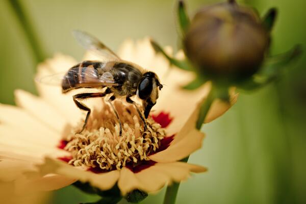
A Quick Snack
A syrphid fly (aka - hoverfly) lands on a flower at a local nursery to grab a quick batch of pollen.
A syrphid fly (aka - hoverfly) lands on a flower at a local nursery to grab a quick batch of pollen.