
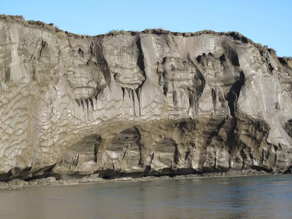
General view of a 35-meter-high riverbank exposure of the ice-rich syngenetic permafrost (yedoma) containing large ice wedges along the Itkillik River in northern Alaska. Copyright-free photo courtesy of Mikhail Kanevskiy; University of Alaska Fairbanks, Institute of Northern Engineering.
Images
Images
Filter Total Items: 9447
Alaska Permafrost
General view of a 35-meter-high riverbank exposure of the ice-rich syngenetic permafrost (yedoma) containing large ice wedges along the Itkillik River in northern Alaska. Copyright-free photo courtesy of Mikhail Kanevskiy; University of Alaska Fairbanks, Institute of Northern Engineering.

Geologists Search for Signs of Tectonic Upheaval in a Marsh on Simeonof Island
Geologists Search for Signs of Tectonic Upheaval in a Marsh on Simeonof IslandScientists from the USGS and the University of Rhode Island examine coastal sediment on Simeonof Island for evidence of sudden land-level change caused by earthquakes on the Aleutian megathrust.

Hurricane Irene Makes Landfall
Upper aerial photograph shows Rodanthe, NC, looking south along the coast on August 30, 2011, three days after landfall of Hurricane Irene. The central and lower aerial photographs show pre-storm and post-storm extreme coastal change, with the yellow arrow in all 3 photographs pointing to the same cottage.
Upper aerial photograph shows Rodanthe, NC, looking south along the coast on August 30, 2011, three days after landfall of Hurricane Irene. The central and lower aerial photographs show pre-storm and post-storm extreme coastal change, with the yellow arrow in all 3 photographs pointing to the same cottage.

Geologists Search for Evidence of Ancient Beach Deposits and Uplifted Shorelines on Simeonof Island
Geologists Search for Evidence of Ancient Beach Deposits and Uplifted Shorelines on Simeonof IslandScientists from the USGS, University of Rhode Island, and the Alaska Dept of Geological and Geophysical Surveys dig into coastal bluffs of Simeonof Island in search of evidence for ancient beach deposits and tectonically uplifted shorelines.

USGS Headquarters
Nestled away in Reston, VA on 105 acres of land, the USGS headquarters was dedicated on July 12, 1974. The building houses over 2000 employees and offers guided and self-guided indoor and outdoor tours to the public.
Nestled away in Reston, VA on 105 acres of land, the USGS headquarters was dedicated on July 12, 1974. The building houses over 2000 employees and offers guided and self-guided indoor and outdoor tours to the public.

Guam Geomagnetic Observatory
Guam geomagnetic observatory.
Guam geomagnetic observatory.

USGS Headquarters
Nestled away in Reston, VA on 105 acres of land, the USGS headquarters was dedicated on July 12, 1974. The building houses over 2000 employees and offers guided and self-guided indoor and outdoor tours to the public.
Nestled away in Reston, VA on 105 acres of land, the USGS headquarters was dedicated on July 12, 1974. The building houses over 2000 employees and offers guided and self-guided indoor and outdoor tours to the public.
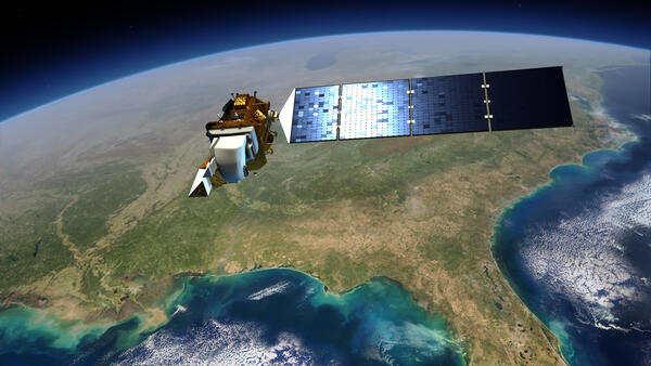
Image of Landsat 8 over the US
This illustration shows the Landsat 8 satellite in space over the southeastern United States.
This illustration shows the Landsat 8 satellite in space over the southeastern United States.

Geologists in Search of Tsunami Deposits on Simeonof Island
Geologists in Search of Tsunami Deposits on Simeonof IslandScientists from the USGS, University of Rhode Island, and the Alaska Dept of Geological and Geophysical Surveys use a hand-driven corer to sample soils and marsh sediment on Simeonof Island as part of an investigation to investigate evidence for earthquakes and tsunamis in the Shumagin Islands.

Green frog USGS photo by Mark Roth.jpg
A green frog blends in well in a grassy wetland. ARMI photo by Mark Roth. Northern Highland-American Legion State Forest, Wisconsin
A green frog blends in well in a grassy wetland. ARMI photo by Mark Roth. Northern Highland-American Legion State Forest, Wisconsin

Baydzherakhs
These are baydzherakhs that form when Pleistocene-aged ice wedges thaw and leave behind a mound of unfrozen soil that is easily susceptible to decomposition. This sediment has not thawed for at least 40,000 years.
These are baydzherakhs that form when Pleistocene-aged ice wedges thaw and leave behind a mound of unfrozen soil that is easily susceptible to decomposition. This sediment has not thawed for at least 40,000 years.

Auwahi Reforestation Area, Maui
View of trees in the Auwahi reforestation area with glimpses of the invasive grassland in the distance.
View of trees in the Auwahi reforestation area with glimpses of the invasive grassland in the distance.

Soil Core Sample #1
Soil core obtained from existing goose grazing lawn along the Smith River in the Teshekpuk Lake Special Area of the National Petroleum Reserve - Alaska. The buried layer of peat beneath goose grazing lawn demonstrates that vegetation change has occurred in this area.
Soil core obtained from existing goose grazing lawn along the Smith River in the Teshekpuk Lake Special Area of the National Petroleum Reserve - Alaska. The buried layer of peat beneath goose grazing lawn demonstrates that vegetation change has occurred in this area.

Auwahi Reforestation Area, Maui
View of the Auwahi reforestation area fence line with native species on the left and invasive grassland on the right.
View of the Auwahi reforestation area fence line with native species on the left and invasive grassland on the right.

Water Sampling with a Kemmerer
Sampling surface waters on Lake Michigan using a Kemmerer Water Sampler
Sampling surface waters on Lake Michigan using a Kemmerer Water Sampler

Soil Core Sample #2
Soil core obtained from existing goose grazing lawn along the Smith River in the Teshekpuk Lake Special Area of the National Petroleum Reserve - Alaska. Buried peat layer broken open. Closer examination of the buried peat layer demonstrates that non-salt-tolerant vegetation from the past was buried in sediment which now supports high-quality goose forage
Soil core obtained from existing goose grazing lawn along the Smith River in the Teshekpuk Lake Special Area of the National Petroleum Reserve - Alaska. Buried peat layer broken open. Closer examination of the buried peat layer demonstrates that non-salt-tolerant vegetation from the past was buried in sediment which now supports high-quality goose forage