
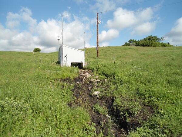
North Dakota Discovery Farms Dazey waterway site 1. Located southeast of Dazey, North Dakota.
Images
Images
Filter Total Items: 9448
Dazey Waterway
North Dakota Discovery Farms Dazey waterway site 1. Located southeast of Dazey, North Dakota.

Railroad Tracks Surrounded by Floodwater
Railroad tracks in Minot, North Dakota surrounded by floodwaters of the Souris River.
Railroad tracks in Minot, North Dakota surrounded by floodwaters of the Souris River.

Jack Hoeven Park Flooded
The Souris River flooding the Jack Hoeven Park in Minot, North Dakota.
The Souris River flooding the Jack Hoeven Park in Minot, North Dakota.

Jack Hoeven Park Underwater
The Souris River flooding the Jack Hoeven Park in Minot, North Dakota.
The Souris River flooding the Jack Hoeven Park in Minot, North Dakota.

Acoustic Doppler
USGS personnel were measuring the streamflow of the Souris River above Minot, ND on June 27, 2011. Streamflow was approximately 23,900 cubic feet per second, stage approximately 23.82 feet.
USGS personnel were measuring the streamflow of the Souris River above Minot, ND on June 27, 2011. Streamflow was approximately 23,900 cubic feet per second, stage approximately 23.82 feet.

Souris River Flooding
Souris River flooding many homes in Minot, ND. The Souris River went over the large dikes along 5th Ave and Edwards Ave in Minot, ND.
Photo taken by USGS personnel during a FEMA Flood Inundation Mapping Project.
Souris River flooding many homes in Minot, ND. The Souris River went over the large dikes along 5th Ave and Edwards Ave in Minot, ND.
Photo taken by USGS personnel during a FEMA Flood Inundation Mapping Project.

Central Ave East Flooded
Looking east on Central Ave East from the intersection of 2nd St. NE and Central Ave East in Minot, North Dakota.
Photo taken by USGS personnel during a FEMA Flood Inundation Mapping Project.
Looking east on Central Ave East from the intersection of 2nd St. NE and Central Ave East in Minot, North Dakota.
Photo taken by USGS personnel during a FEMA Flood Inundation Mapping Project.

Souris River Flooding
Souris River in Minot, North Dakota flooded many buildings and homes in the Odds Mobile Home Park.
Photo taken by USGS personnel during a FEMA Flood Inundation Mapping Project.
Souris River in Minot, North Dakota flooded many buildings and homes in the Odds Mobile Home Park.
Photo taken by USGS personnel during a FEMA Flood Inundation Mapping Project.

Odds Moblie Home Park Flooded
Souris River in Minot, North Dakota flooded many buildings and homes in the Odds Mobile Home Park.
Photo taken by USGS personnel during a FEMA Flood Inundation Mapping Project.
Souris River in Minot, North Dakota flooded many buildings and homes in the Odds Mobile Home Park.
Photo taken by USGS personnel during a FEMA Flood Inundation Mapping Project.

Flooded Outhouse in N.D. Wildlife Preserve
While the Souris River is in the throes of record high flooding in Minot, N.D., O.C. Fisher Lake near San Angelo, Texas has been experiencing the exact opposite for a number of years now - a ground-cracking drought.
While the Souris River is in the throes of record high flooding in Minot, N.D., O.C. Fisher Lake near San Angelo, Texas has been experiencing the exact opposite for a number of years now - a ground-cracking drought.

Flooding near Lake Darling
Flooded roadway near Lake Darling in North Dakota.
Flooded roadway near Lake Darling in North Dakota.

Souris River Flooding
Souris River flooding 8th Ave SE and the bridge in Minot, ND.
Photo taken by USGS personnel during a FEMA Flood Inundation Mapping Project.
Souris River flooding 8th Ave SE and the bridge in Minot, ND.
Photo taken by USGS personnel during a FEMA Flood Inundation Mapping Project.

Highway 2 by Minot, Nroth Dakota
Looking northeast along Highway 2 by Minot, North Dakota.
Photo taken by USGS personnel during a FEMA Flood Inundation Mapping Project.
Looking northeast along Highway 2 by Minot, North Dakota.
Photo taken by USGS personnel during a FEMA Flood Inundation Mapping Project.

Flooded Highway
Looking northeast along Highway 2 by Minot, North Dakota.
Photo taken by USGS personnel during a FEMA Flood Inundation Mapping Project.
Looking northeast along Highway 2 by Minot, North Dakota.
Photo taken by USGS personnel during a FEMA Flood Inundation Mapping Project.

SunPrairie Grain Surounded by Water
Looking north where the Souris River floods the SunPrairie Grain (left), and TLC Pet Resort and Salon (right).
Photo taken by USGS personnel during a FEMA Flood Inundation Mapping Project.
Looking north where the Souris River floods the SunPrairie Grain (left), and TLC Pet Resort and Salon (right).
Photo taken by USGS personnel during a FEMA Flood Inundation Mapping Project.

Flooding in Downtown Minot, N.D.
While the Souris River is in the throes of record high flooding in Minot, N.D., O.C. Fisher Lake near San Angelo, Texas has been experiencing the exact opposite for a number of years now - a ground-cracking drought.
While the Souris River is in the throes of record high flooding in Minot, N.D., O.C. Fisher Lake near San Angelo, Texas has been experiencing the exact opposite for a number of years now - a ground-cracking drought.

Flooding Odds Mobile Home Park
Souris River in Minot, North Dakota flooded many buildings and homes in the Odds Mobile Home Park.
Photo taken by USGS personnel during a FEMA Flood Inundation Mapping Project.
Souris River in Minot, North Dakota flooded many buildings and homes in the Odds Mobile Home Park.
Photo taken by USGS personnel during a FEMA Flood Inundation Mapping Project.

Odds Moblie Home Park Underwater
Souris River in Minot, North Dakota flooded many buildings and homes in the Odds Mobile Home Park.
Photo taken by USGS personnel during a FEMA Flood Inundation Mapping Project.
Souris River in Minot, North Dakota flooded many buildings and homes in the Odds Mobile Home Park.
Photo taken by USGS personnel during a FEMA Flood Inundation Mapping Project.

Sunset near Lake Darling
Floodedwaters at sunset near Lake Darling in North Dakota.
Floodedwaters at sunset near Lake Darling in North Dakota.

Flooding in Minot, North Dakota
Souris River flooding 8th Ave SE bridge in Minot, ND.
Photo taken by USGS personnel during a FEMA Flood Inundation Mapping Project.
Souris River flooding 8th Ave SE bridge in Minot, ND.
Photo taken by USGS personnel during a FEMA Flood Inundation Mapping Project.

Souris River Rises
Looking east at Burdick Expressway as the Souris River rises in Minot, North Dakota.
Photo taken by USGS personnel during a FEMA Flood Inundation Mapping Project.
Looking east at Burdick Expressway as the Souris River rises in Minot, North Dakota.
Photo taken by USGS personnel during a FEMA Flood Inundation Mapping Project.