
Hydropower turbines at Garrison Dam in North Dakota.
Images
Images
Filter Total Items: 9448

Garrison Dam
Hydropower turbines at Garrison Dam in North Dakota.

Devils Lake Basin Flyover
U.S. Geological Survey participiated in a flyover of the Devils Lake Basin to view continued severe flooding.
U.S. Geological Survey participiated in a flyover of the Devils Lake Basin to view continued severe flooding.

Devils Lake Basin Flyover
U.S. Geological Survey participiated in a flyover of the Devils Lake Basin to view continued severe flooding.
U.S. Geological Survey participiated in a flyover of the Devils Lake Basin to view continued severe flooding.

Devils Lake Basin Flyover
U.S. Geological Survey participiated in a flyover of Devils Lake Basin, North Dakota, to view continued severe flooding.
U.S. Geological Survey participiated in a flyover of Devils Lake Basin, North Dakota, to view continued severe flooding.

Devils Lake Basin Flyover
U.S. Geological Survey participiated in a flyover of the Devils Lake Basin to view continued severe flooding.
U.S. Geological Survey participiated in a flyover of the Devils Lake Basin to view continued severe flooding.

Devils Lake Basin Flyover
U.S. Geological Survey participiated in a flyover of the Devils Lake Basin to view continued severe flooding.
U.S. Geological Survey participiated in a flyover of the Devils Lake Basin to view continued severe flooding.

Devils Lake Basin Flyover
U.S. Geological Survey participiated in a flyover of the Devils Lake Basin to view continued severe flooding.
U.S. Geological Survey participiated in a flyover of the Devils Lake Basin to view continued severe flooding.

Garrison Dam Spillway
On June 9, 2011, USGS personel were at the Garrison Dam Spillway, between Pick City and Riverdale, North Dakota.
On June 9, 2011, USGS personel were at the Garrison Dam Spillway, between Pick City and Riverdale, North Dakota.

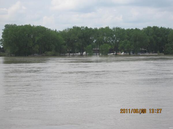
Missouri River
As the Missouri River is rising, it's flooding a lot of land.
As the Missouri River is rising, it's flooding a lot of land.

Garrison Dam Spillway
On June 9, 2011, USGS personel were at the Garrison Dam Spillway, between Pick City and Riverdale, North Dakota.
On June 9, 2011, USGS personel were at the Garrison Dam Spillway, between Pick City and Riverdale, North Dakota.

Keelboat Boat Ramp and Parking Lot Underwater
The Missouri River flooding the parking lot and the Keelboat Boat Ramp in Bismarck, North Dakota.
The Missouri River flooding the parking lot and the Keelboat Boat Ramp in Bismarck, North Dakota.

Garrison Dam Spillway
On June 9, 2011, USGS personel were at the Garrison Dam Spillway, between Pick City and Riverdale, North Dakota.
On June 9, 2011, USGS personel were at the Garrison Dam Spillway, between Pick City and Riverdale, North Dakota.

Keelboat Park and Boat Ramp
The Missouri River flooding Keelboat Park and Keelboat Boat Ramp in Bismarck, ND. In the background is the Burlington Northern SantaFe Railway Bridge.
The Missouri River flooding Keelboat Park and Keelboat Boat Ramp in Bismarck, ND. In the background is the Burlington Northern SantaFe Railway Bridge.
Bismarck, North Dakota Gage House
This is the Bismarck, ND gage house located along the Missouri River. The gage house includes information on the Missouri River flooding in 2011, along with the marking of the flood stage at 27.90 feet on April 6, 1952. The tan line that goes all the way around the gage house is the mark.
This is the Bismarck, ND gage house located along the Missouri River. The gage house includes information on the Missouri River flooding in 2011, along with the marking of the flood stage at 27.90 feet on April 6, 1952. The tan line that goes all the way around the gage house is the mark.
Dike Protecting Homes
Large Dike along the Missouri River protects homes along the West side of the River in Mandan, ND.
Large Dike along the Missouri River protects homes along the West side of the River in Mandan, ND.

Flooded Park Shelter
The Missouri River floods Pioneer Park and its shelter. Located in Bismarck, North Dakota.
The Missouri River floods Pioneer Park and its shelter. Located in Bismarck, North Dakota.

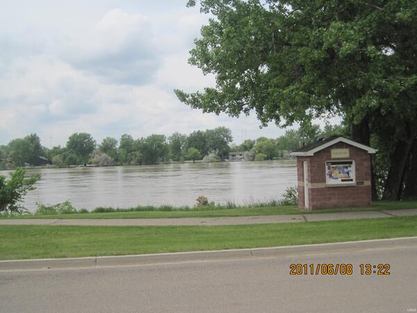
Steamboat Replica
The Steamboat replica located in Streamboat Park along River Road in Bismarck, North Dakota.
The Steamboat replica located in Streamboat Park along River Road in Bismarck, North Dakota.

Geese in the Missouri River
Geese swimming in the flooding Missouri River along River Road in Bismarck, North Dakota.
Geese swimming in the flooding Missouri River along River Road in Bismarck, North Dakota.
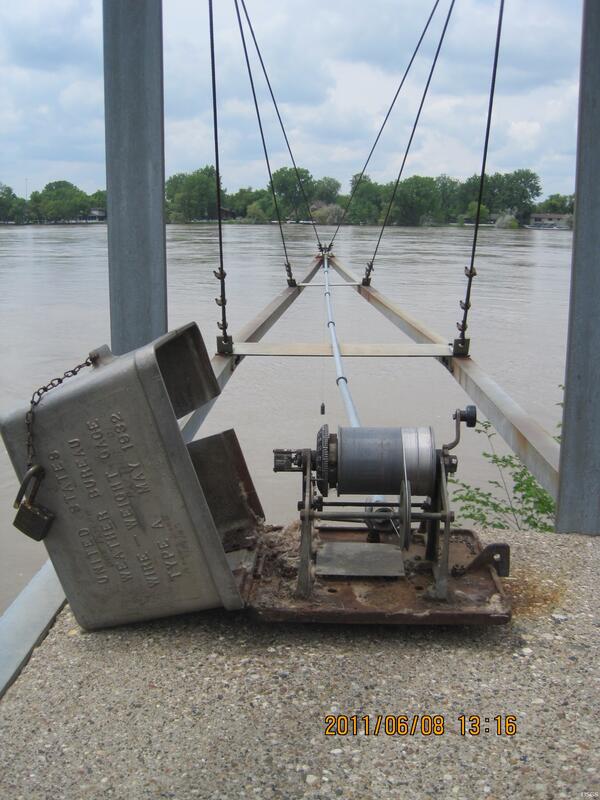
Wire Weight
Wire weight is lowered to water surface to measure stage at a site. Levels are made to the wire weights elevation from known benchmarks to ensure correct readings. This wire weight is located along the Missouri River in Bismarck, ND.
Wire weight is lowered to water surface to measure stage at a site. Levels are made to the wire weights elevation from known benchmarks to ensure correct readings. This wire weight is located along the Missouri River in Bismarck, ND.
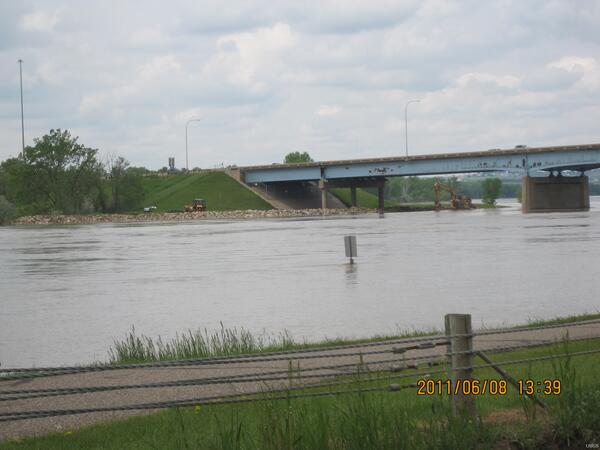
Rip Rap Around Grant Marsh Bridge
Crews add rip rap around key river structures to inhibit erosion and scouring from occuring and possibly underminding the stability of the structure. Creating rip rap around the Grant Marsh Bridge between Mandan and Bismarck, ND.
Crews add rip rap around key river structures to inhibit erosion and scouring from occuring and possibly underminding the stability of the structure. Creating rip rap around the Grant Marsh Bridge between Mandan and Bismarck, ND.

Pioneer Park Pumping Station
The Pioneer Park Pumping Station City of Bismarck is surrounded by a dike to protect it from the rising Missouri River.
The Pioneer Park Pumping Station City of Bismarck is surrounded by a dike to protect it from the rising Missouri River.