
The USGS Souris River at Foxholm, N.D. streamgage (center of photo) is half inundated by water about 30 miles northwest of Minot. This water channel, normally only about 30 feet wide, runs through a wildlife preserve.
Images
Images
Filter Total Items: 9448

USGS Streamgage Flooded by Souris River
The USGS Souris River at Foxholm, N.D. streamgage (center of photo) is half inundated by water about 30 miles northwest of Minot. This water channel, normally only about 30 feet wide, runs through a wildlife preserve.

Souris River above Minot, North Dakota
USGS personnel were measuring the streamflow of the Souris River above Minot, ND on June 24, 2011. Streamflow was approximately 20,800 cubic feet per second, stage approximately 23.46 feet.
USGS personnel were measuring the streamflow of the Souris River above Minot, ND on June 24, 2011. Streamflow was approximately 20,800 cubic feet per second, stage approximately 23.46 feet.

Black-and-White Larval Sturgeon
Collected in the Lower Missouri River on May 20, 2011, near Arrow Rock, Missouri, this larval sturgeon is estimated to be one day old.
Collected in the Lower Missouri River on May 20, 2011, near Arrow Rock, Missouri, this larval sturgeon is estimated to be one day old.

Field sampling boat with USGS PFD in the Great Salt wetlands
Field sampling boat with USGS PFD in the Great Salt wetlandsWetland habitats, such as the Great Salt Lake wetlands, provide critical feeding areas for many fish and wildlife species.
Field sampling boat with USGS PFD in the Great Salt wetlands
Field sampling boat with USGS PFD in the Great Salt wetlandsWetland habitats, such as the Great Salt Lake wetlands, provide critical feeding areas for many fish and wildlife species.

Missouri River Spring Flood
Release of 80,000 cfs from Oahe Dam, near Pierre SD on May 27, 2011. This is the largest release since Oahe Reservoir Filled in 1959. Releases are expected to increase to 150,000 cfs before mid-June.
Release of 80,000 cfs from Oahe Dam, near Pierre SD on May 27, 2011. This is the largest release since Oahe Reservoir Filled in 1959. Releases are expected to increase to 150,000 cfs before mid-June.

Keelboat Park Boat Ramp
The Keelboat Park Boat Ramp in Bismarck, ND, underwater while the Missouri River keeps rising.
The Keelboat Park Boat Ramp in Bismarck, ND, underwater while the Missouri River keeps rising.

Missouri River Spring Flood
USGS Crews collecting a discharge measurement on the Missouri River downstream of Oahe Reservoir near Pierre, SD. Releases from Oahe Reservoir are at 80,000 cfs on May 27 and projected to increase to 150,000 by mid-June at the latest. Evacuations in Pierre, SD have been issued and sandbagging in an effort to protect homes and infrastructure is ongo
USGS Crews collecting a discharge measurement on the Missouri River downstream of Oahe Reservoir near Pierre, SD. Releases from Oahe Reservoir are at 80,000 cfs on May 27 and projected to increase to 150,000 by mid-June at the latest. Evacuations in Pierre, SD have been issued and sandbagging in an effort to protect homes and infrastructure is ongo

Burlington Northern Santa Fe Railway Bridge
The Burlington Northern Santa Fe Railway Bridge in Bismarck, ND, with high waters of the Missouri River.
The Burlington Northern Santa Fe Railway Bridge in Bismarck, ND, with high waters of the Missouri River.

The Little Missouri River
The Little Missouri River at Watford City, North Dakota, on May 26, 2011.
The Little Missouri River at Watford City, North Dakota, on May 26, 2011.
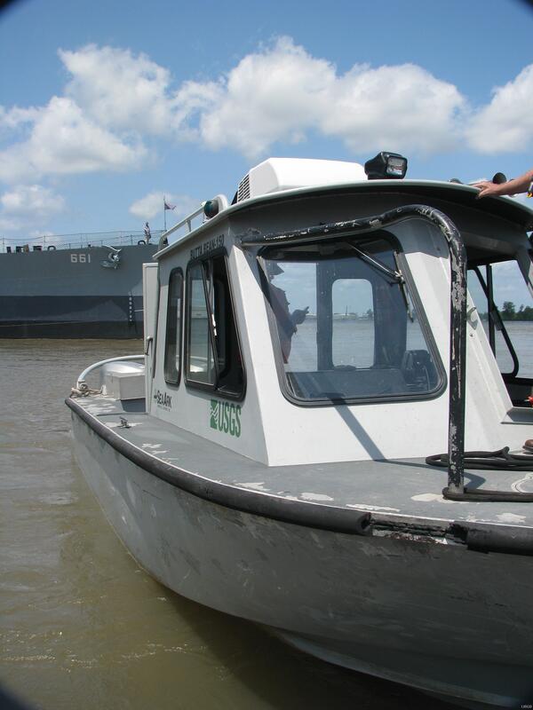
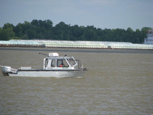
The Butta Bean-150
The Butta Bean-150, one of the USGS Louisiana Water Science Center's fleet. She measures 23 feet long and is used to take streamflow and water quality measurements.
The Butta Bean-150, one of the USGS Louisiana Water Science Center's fleet. She measures 23 feet long and is used to take streamflow and water quality measurements.
USGS Baton Rouge Streamgage
The USGS streamgage at the Baton Rouge City Docks.
The USGS streamgage at the Baton Rouge City Docks.
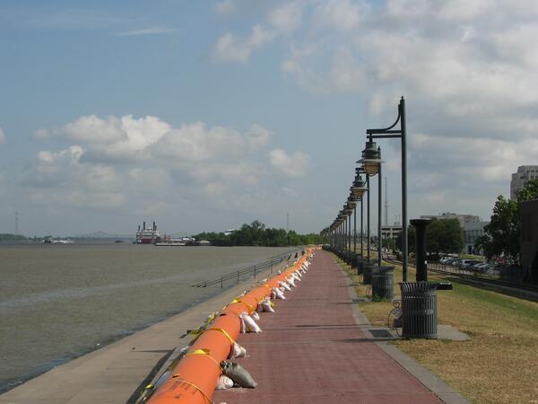
Tiger Dams Reinforce Baton Rouge Levees
Tiger Dams line the Baton Rouge Mississippi River levee during the 2011 Flood. Previously used to prevent oil from reaching Louisiana's coast during the 2010 Deepwater Horizon oil spill, these Tiger Dams are filled with water and reinforced with sandbags to give the Baton Rouge Mississippi River levee an extra foot of height. This additional height is pr
Tiger Dams line the Baton Rouge Mississippi River levee during the 2011 Flood. Previously used to prevent oil from reaching Louisiana's coast during the 2010 Deepwater Horizon oil spill, these Tiger Dams are filled with water and reinforced with sandbags to give the Baton Rouge Mississippi River levee an extra foot of height. This additional height is pr
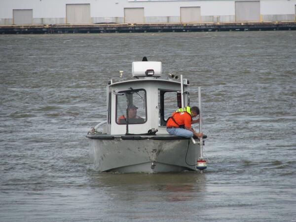
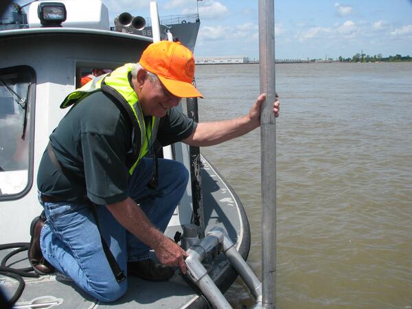
USGS Takes Streamflow Measurements
USGS hydrologist Todd Baumann makes a streamflow measurement of the Mississippi River aboard the Butta Bean during the 2011 Flood. USGS makes streamflow measurements by using an Acoustic Doppler Current Profiler (ADCP), which emits soundwaves through the water column. These soundwaves rebound off particles in the water until they reach the river bottom.
USGS hydrologist Todd Baumann makes a streamflow measurement of the Mississippi River aboard the Butta Bean during the 2011 Flood. USGS makes streamflow measurements by using an Acoustic Doppler Current Profiler (ADCP), which emits soundwaves through the water column. These soundwaves rebound off particles in the water until they reach the river bottom.
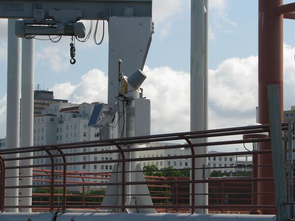
George Arcement Demonstrates the ADCP
USGS Water Science Center Director George Arcement demonstrates the Acoustic Doppler Current Profiler (ADCP) to legislative staffers. USGS uses the ADCP to make streamflow measurements. The ADCP emits soundwaves through the water column, which rebound off particles in the water until they reach the river bottom.
USGS Water Science Center Director George Arcement demonstrates the Acoustic Doppler Current Profiler (ADCP) to legislative staffers. USGS uses the ADCP to make streamflow measurements. The ADCP emits soundwaves through the water column, which rebound off particles in the water until they reach the river bottom.

Yellowstone River
High waters in the Yellowstone River at Glendive, Montana.
High waters in the Yellowstone River at Glendive, Montana.
USGS Takes Streamflow Measurements
USGS crews aboard the Butta Bean measure streamflow on the Mississippi River during the 2011 Flood. At the height of the flood, USGS crews are out every other day taking streamflow measurements to ensure the US Army Corps of Engineers has accurate, up-to-date information with which to base its river management decisions.
USGS crews aboard the Butta Bean measure streamflow on the Mississippi River during the 2011 Flood. At the height of the flood, USGS crews are out every other day taking streamflow measurements to ensure the US Army Corps of Engineers has accurate, up-to-date information with which to base its river management decisions.
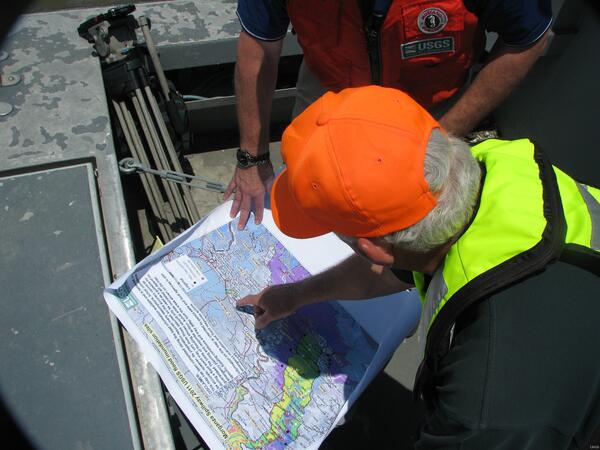
George Arcement Shows Locations of USGS Streamgages
George Arcement Shows Locations of USGS StreamgagesUSGS Louisiana Water Science Center Director George Arcement shows the locations of USGS' streamgage network to WAFB Meteorologist Jay Grymes. USGS maintains more than 30 real-time streamgages throughout the area affected by the 2011 Flood.

Yellowstone River
Bridge over the Yellowstone River at Glendive, Montana.
Bridge over the Yellowstone River at Glendive, Montana.

2011 Spring Flood
Invasive Giant Salvinia clogs one end of Lake Murphy. Lake Murphy is home to three of Louisiana's most problematic invasive aquatic plant species: Giant Salvinia, Water Hyacinth, and Hydrilla. As the record-setting 2011 floodwaters push through the Atchafalaya Basin, USGS crews are monitoring these invasive species to see what effects the water have on them.
Invasive Giant Salvinia clogs one end of Lake Murphy. Lake Murphy is home to three of Louisiana's most problematic invasive aquatic plant species: Giant Salvinia, Water Hyacinth, and Hydrilla. As the record-setting 2011 floodwaters push through the Atchafalaya Basin, USGS crews are monitoring these invasive species to see what effects the water have on them.

2011 Spring Flood
Invasive species Giant Salvinia and Water Hyacinth clog one end of Lake Murphy. Lake Murphy is home to three of Louisiana’s most problematic invasive aquatic plant species: Giant Salvinia, Water Hyacinth, and Hydrilla.
Invasive species Giant Salvinia and Water Hyacinth clog one end of Lake Murphy. Lake Murphy is home to three of Louisiana’s most problematic invasive aquatic plant species: Giant Salvinia, Water Hyacinth, and Hydrilla.

2011 Spring Flood
A camp lies flooded on the edge of the Florida Gas Canal. Rising floodwaters during the 2011 flood have inundated many hunting camps and residences. Flooded even before the additional water from the Morganza Spillway arrived, these camps were built on land that is usually well above the water level and safely back from the canal's edge.
A camp lies flooded on the edge of the Florida Gas Canal. Rising floodwaters during the 2011 flood have inundated many hunting camps and residences. Flooded even before the additional water from the Morganza Spillway arrived, these camps were built on land that is usually well above the water level and safely back from the canal's edge.