Ticks spread the widest variety of diseases that are harmful to humans, including Lyme disease. This image shows a female blacklegged tick, or deer tick (species Ixodes scapularis).
Images
Images
Filter Total Items: 9448

Female Deer Tick
Ticks spread the widest variety of diseases that are harmful to humans, including Lyme disease. This image shows a female blacklegged tick, or deer tick (species Ixodes scapularis).

Mississippi River Flooding 2011: Birds Point-New Madrid Floodway
Mississippi River Flooding 2011: Birds Point-New Madrid FloodwayUSGS Hydrographer measures streamflow at Birds Point-New Madrid floodway using a tethered acoustic Doppler current profiling from a moving boat. USGS scientists are measuring the amount of water spilling into the New Madrid floodway as a result of the recent intentional breaching of the Birds Point Levee in Missouri in support of the Corps of Engineers operation.

Mississippi River Flooding 2011: Birds Point-New Madrid Floodway
Mississippi River Flooding 2011: Birds Point-New Madrid FloodwayUSGS National Flood Specialist answers questions for CNN at the Birds Point-NewMadrid Floodway. USGS scientists are measuring the amount of water spilling into the New Madrid floodway as a result of the recent intentional breaching of the Birds Point Levee in Missouri in support of the Corps of Engineers operation.
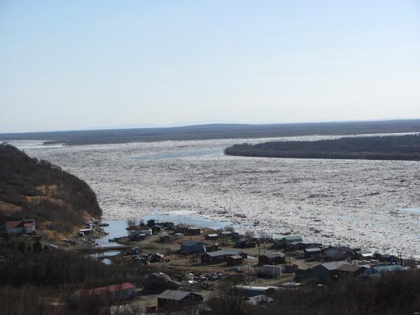
Yukon River
Yukon River at Pilot Station AK ice movement during breakup.
Yukon River at Pilot Station AK ice movement during breakup.

Disappearing Shorebird Habitat
Shorebirds feeding on a diked-off area of former intertidal mudflats at a reclamation project in Bohai Bay, Yellow Sea, China. The substrate the birds are feeding on is mud and sand that has been pumped into the impoundment from beyond the levee (dredge in background).
Shorebirds feeding on a diked-off area of former intertidal mudflats at a reclamation project in Bohai Bay, Yellow Sea, China. The substrate the birds are feeding on is mud and sand that has been pumped into the impoundment from beyond the levee (dredge in background).

Lamprey
Pacific lamprey, Hamma-Hamma River, dwarf adult.
Pacific lamprey, Hamma-Hamma River, dwarf adult.

Lamprey
River lamprey (L. ayresii), macrophthalmia, dentition.
River lamprey (L. ayresii), macrophthalmia, dentition.

Prescribed Burn
Prescribed burn in a coastal sawgrass marsh at a USGS hydrologic station in Everglades National Park.
Prescribed burn in a coastal sawgrass marsh at a USGS hydrologic station in Everglades National Park.
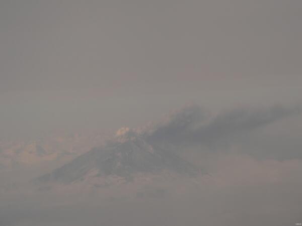
Mt Redoubt Volcanic Explosion
Mt Redoubt southcentral AK ice movement during breakup.
Mt Redoubt southcentral AK ice movement during breakup.

Magnificent Seven
Marine ecologists from USGS Western Ecological Research Center, USGS Alaska Science Center, UC Santa Cruz and Monterey Bay Aquarium prepare to board the R/V Alaska Gyre for their 2011 May sea otter capture expedition for the Pacific Nearshore Project.
Marine ecologists from USGS Western Ecological Research Center, USGS Alaska Science Center, UC Santa Cruz and Monterey Bay Aquarium prepare to board the R/V Alaska Gyre for their 2011 May sea otter capture expedition for the Pacific Nearshore Project.

When Elk are Excluded, Aspen Growth Dramatically Increases
When Elk are Excluded, Aspen Growth Dramatically IncreasesClimate change in the form of reduced snowfall in mountains is causing powerful and cascading shifts in montane plant and bird communities through the increased ability of elk to stay at high elevations over winter and consume plants. Here, you can see an example of the difference in aspen growth inside versus outside a fence that excludes elk.

Emerging Contaminants Might Affect Tree Swallow Reproduction
Emerging Contaminants Might Affect Tree Swallow ReproductionContamination from commercial products such as nonstick cookware and stain repellents could reduce the reproduction of tree swallows nesting in Minnesota and Wisconsin.
Emerging Contaminants Might Affect Tree Swallow Reproduction
Emerging Contaminants Might Affect Tree Swallow ReproductionContamination from commercial products such as nonstick cookware and stain repellents could reduce the reproduction of tree swallows nesting in Minnesota and Wisconsin.

Setting Collection Trap in Coastal Waters
Researchers setting a trap to collect specimens in nearshore coastal waters
Researchers setting a trap to collect specimens in nearshore coastal waters

Helicopters
Helicopters assisting USGS scientists in Everglades National Park.
Helicopters assisting USGS scientists in Everglades National Park.

Diver with Tape
USGS divers Steve Rubin and Reg Reisenbichler laying out a survey transect. Completing his 12th dive at the site in 2023, Rubin has been conducting dive surveys around the mouth of the Elwha River for over a decade as part of an evaluation of ecosystem health and recovery since the Elwha dams were breached in 2011.
USGS divers Steve Rubin and Reg Reisenbichler laying out a survey transect. Completing his 12th dive at the site in 2023, Rubin has been conducting dive surveys around the mouth of the Elwha River for over a decade as part of an evaluation of ecosystem health and recovery since the Elwha dams were breached in 2011.

Silver and Bighead Carp
These silver and bighead carp were collected on the Illinois River to learn more about the anatomy and physiology of Asian carp. This information will guide the development of potential biological or chemical controls as part of an integrated pest management approach for natural resource managers.
These silver and bighead carp were collected on the Illinois River to learn more about the anatomy and physiology of Asian carp. This information will guide the development of potential biological or chemical controls as part of an integrated pest management approach for natural resource managers.

Mississippi River Flooding 2011: Birds Point-New Madrid Floodway
Mississippi River Flooding 2011: Birds Point-New Madrid FloodwayUSGS Missouri Water Science Center Deputy Director near inflow/outflow of the levee breach near New Madrid, MO. USGS scientists are measuring the amount of water spilling into the New Madrid floodway as a result of the recent intentional breaching of the Birds Point Levee in Missouri in support of the Corps of Engineers operation.

Black River at Pocahontas, AR
USGS Arkansas Water Science Cneter technicians measuring the flow across a US Highway being passed by a fan boat.
USGS Arkansas Water Science Cneter technicians measuring the flow across a US Highway being passed by a fan boat.

Lamprey
Pacific lamprey ammocoete, tail pattern.
Pacific lamprey ammocoete, tail pattern.

Bighead Carp
This bighead carp was collected on the Illinois River to learn more about the anatomy and physiology of Asian carp. This information will guide the development of potential biological or chemical controls as part of an integrated pest management approach for natural resource managers.
This bighead carp was collected on the Illinois River to learn more about the anatomy and physiology of Asian carp. This information will guide the development of potential biological or chemical controls as part of an integrated pest management approach for natural resource managers.