
Discovery Farm Dazey waterway site 3 located southeast of Dazey, North Dakota. Dazey waterway saite 3 is the most downstream data shelter at farm- added larger 2.5 foot flume and reinforced metal weir after 2009 spring runoff flow damaged site.
Images
Images
Filter Total Items: 9448
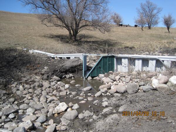
Discovery Farm Dazey Waterway Site 3
Discovery Farm Dazey waterway site 3 located southeast of Dazey, North Dakota. Dazey waterway saite 3 is the most downstream data shelter at farm- added larger 2.5 foot flume and reinforced metal weir after 2009 spring runoff flow damaged site.
Underwood Farm Feedlot Runoff
North Dakota Discovery Farms Underwood Farm owned and operated by Doyle and Patsy Johannes and their family since 19.4. Located west of Underwood, North Dakota. In 2008, Underwood Farm became the first farm in the North Dakota Discovery Farms project.
North Dakota Discovery Farms Underwood Farm owned and operated by Doyle and Patsy Johannes and their family since 19.4. Located west of Underwood, North Dakota. In 2008, Underwood Farm became the first farm in the North Dakota Discovery Farms project.

Black River Flooding
USGS employees Joey Fleming and Steve Flants taking flow measurements on the Black River at Black Rock, AR. Waters reached 16 feet above floodstage.
USGS employees Joey Fleming and Steve Flants taking flow measurements on the Black River at Black Rock, AR. Waters reached 16 feet above floodstage.

Tuscaloosa-Birmingham Tornado Scar, April 2011
The roughly west-east trail of destruction from the April 27, 2011, Tuscaloosa-Birmingham tornado is clearly visible in these Landsat images. This was one of 358 recorded tornadoes during the April 25-28, 2011, tornado outbreak, the most severe in U.S. history.
The roughly west-east trail of destruction from the April 27, 2011, Tuscaloosa-Birmingham tornado is clearly visible in these Landsat images. This was one of 358 recorded tornadoes during the April 25-28, 2011, tornado outbreak, the most severe in U.S. history.

Black River Flooding
USGS employees Joey Fleming and Steve Flants taking flow measurements on the Black River at Black Rock, AR. Waters reached 16 feet above floodstage.
USGS employees Joey Fleming and Steve Flants taking flow measurements on the Black River at Black Rock, AR. Waters reached 16 feet above floodstage.

Black River Flooding
USGS employee Tedd Wallace taking flow measurments with a teathered boat on the Black River at Black Rock, AR. Waters reached 16 feet above floodstage.
USGS employee Tedd Wallace taking flow measurments with a teathered boat on the Black River at Black Rock, AR. Waters reached 16 feet above floodstage.

Flooding of the Souris River
April 27, 2011, flooding of the Souris (Mouse) River near Westhope, North Dakota. The small building is the U.S. Geological Survey gage house and is normally on the river bank and raised so that one needs to take stairs up to get into the gage house. There is also an access road next to the gage house and electrical pole.
April 27, 2011, flooding of the Souris (Mouse) River near Westhope, North Dakota. The small building is the U.S. Geological Survey gage house and is normally on the river bank and raised so that one needs to take stairs up to get into the gage house. There is also an access road next to the gage house and electrical pole.

Muskrat at the Souris River
One of many muskrats at the Souris River near Westhope, North Dakota. Streamflow was measured by USGS personnel in the boat and was approximately 12,200 cubic feet per second and gage height (stage) was 18.90 feet. For perspective, flood stage is 10 feet, moderate flood stage is 14 feet, and major flood stage is 16 feet.
One of many muskrats at the Souris River near Westhope, North Dakota. Streamflow was measured by USGS personnel in the boat and was approximately 12,200 cubic feet per second and gage height (stage) was 18.90 feet. For perspective, flood stage is 10 feet, moderate flood stage is 14 feet, and major flood stage is 16 feet.

Gasconade River Flood
USGS field crew taking measurments of the Gasconade River at Jerome, MO. The measurement was taken using an Acoustic Doppler Current Profiler (ADCP) on a tethered boat.
USGS field crew taking measurments of the Gasconade River at Jerome, MO. The measurement was taken using an Acoustic Doppler Current Profiler (ADCP) on a tethered boat.

Black River Flooding
USGS employee Tedd Wallace taking flow measurments with a teathered boat on the Black River at Black Rock, AR. Waters reached 16 feet above floodstage.
USGS employee Tedd Wallace taking flow measurments with a teathered boat on the Black River at Black Rock, AR. Waters reached 16 feet above floodstage.

Flooding of the Souris River
April 27, 2011, flooding of the Souris (Mouse) River near Westhope, North Dakota. The small building is the U.S. Geological Survey gage house and is normally on the river bank and raised so that one needs to take stairs up to get into the gage house. There is also an access road next to the gage house and electrical pole.
April 27, 2011, flooding of the Souris (Mouse) River near Westhope, North Dakota. The small building is the U.S. Geological Survey gage house and is normally on the river bank and raised so that one needs to take stairs up to get into the gage house. There is also an access road next to the gage house and electrical pole.

Souris River Muskrat
One of many muskrats at the Souris River near Westhope, North Dakota.Streamflow was measured by USGS personnel in the boat and was approximately 12,200 cubic feet per second and gage height (stage) was 18.90 feet. For perspective, flood stage is 10 feet, moderate flood stage is 14 feet, and major flood stage is 16 feet.
One of many muskrats at the Souris River near Westhope, North Dakota.Streamflow was measured by USGS personnel in the boat and was approximately 12,200 cubic feet per second and gage height (stage) was 18.90 feet. For perspective, flood stage is 10 feet, moderate flood stage is 14 feet, and major flood stage is 16 feet.

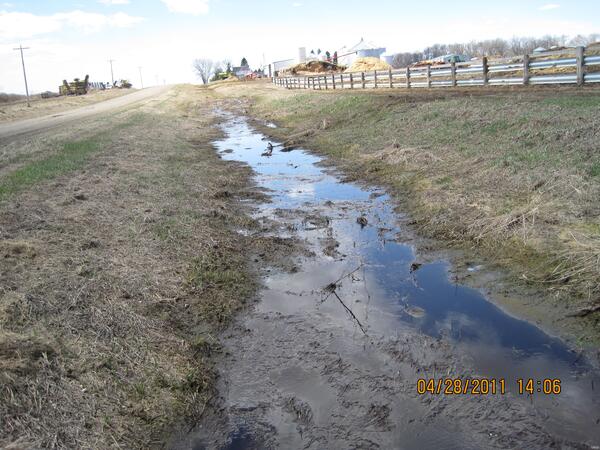
Underwood Waterway Site
North Dakota Discovery Farms Underwood waterway site 1, located west of Underwood, ND.
North Dakota Discovery Farms Underwood waterway site 1, located west of Underwood, ND.

ND Discovery Farm Underwood Waterway
North Dakota Discovery Farms Underwood waterway site 3 at Underwood, ND
North Dakota Discovery Farms Underwood waterway site 3 at Underwood, ND

USGS Crews Measure Flooding in Missouri
USGS scientist, Paul Brenden makes a flood measurement on the Big Piney near Big Piney Missouri.
USGS scientist, Paul Brenden makes a flood measurement on the Big Piney near Big Piney Missouri.

French Lick Creek Flood
French Lick Creek flood west of Baden Springs, IN.
French Lick Creek flood west of Baden Springs, IN.

Flood Overflow
Overflow on West Baden Springs Resort Road.
Overflow on West Baden Springs Resort Road.

Lost River Flood
Lost River flood, Prospect, IN.
Lost River flood, Prospect, IN.

French Lick Creek Flood
French Lick Creek flood west Baden Springs, IN.
French Lick Creek flood west Baden Springs, IN.

Flood at USGS station 07048600, White River nr. Fayetteville, Arkansas
Flood at USGS station 07048600, White River nr. Fayetteville, ArkansasFlood of April 25, 2011, at USGS streamflow-gaging station 07048600, White River near Fayetteville, Arkansas. Photograph by K.M. Hubbs, Lower Mississippi-Gulf Water Science Center.

French Lick Creek Flood
French Lick Creek flood west Baden Springs, IN.
French Lick Creek flood west Baden Springs, IN.