
James River above Arrowwood Lake near Kensal, North Dakota on April 13. James River had a streamflow of 6,550 cubic feet per second and stage of 13.84 feet.
Images
Images
Filter Total Items: 9448

James River above Arrowwood Lake
James River above Arrowwood Lake near Kensal, North Dakota on April 13. James River had a streamflow of 6,550 cubic feet per second and stage of 13.84 feet.

Water Flowing Under the Bridge
James River above Arrowwood Lake near Kensal, North Dakota on April 13. James River had a streamflow of 6,550 cubic feet per second and stage of 13.84 feet.
James River above Arrowwood Lake near Kensal, North Dakota on April 13. James River had a streamflow of 6,550 cubic feet per second and stage of 13.84 feet.

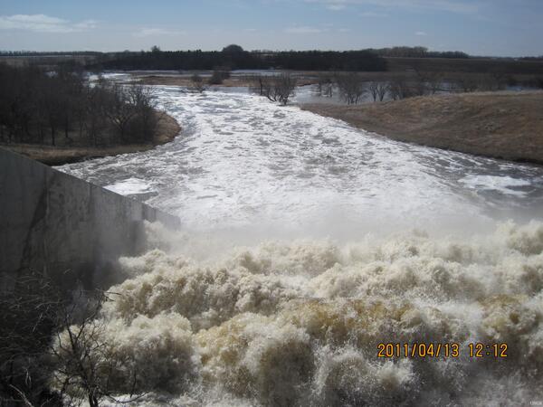
View of Maple River Dam Overflow Chute
Water flowing over the baffles of the overflow chute at streamgage 05059715 Maple River Dam near Sheldon, North Dakota.
Water flowing over the baffles of the overflow chute at streamgage 05059715 Maple River Dam near Sheldon, North Dakota.

Flooding of James River above Arrowwood Lake
James River above Arrowwood Lake near Kensal, North Dakota flooding on April 13. James River had a streamflow of 6,550 cubic feet per second and stage of 13.84 feet.
James River above Arrowwood Lake near Kensal, North Dakota flooding on April 13. James River had a streamflow of 6,550 cubic feet per second and stage of 13.84 feet.

Maple River Dam Overflow Chute
Water flowing over the baffles of the overflow chute at streamgage 05059715 Maple River Dam near Sheldon, North Dakota.
Water flowing over the baffles of the overflow chute at streamgage 05059715 Maple River Dam near Sheldon, North Dakota.

Sorlie Bridge Flooded
Looking at the Sorlie Bridge at Grand Forks, ND from downstream.
Looking at the Sorlie Bridge at Grand Forks, ND from downstream.
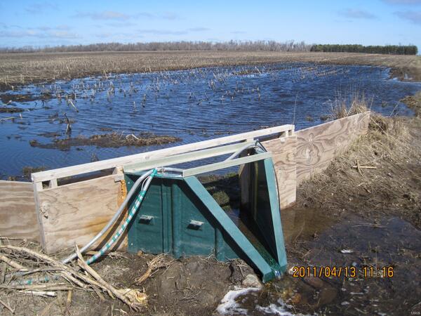
Flume at Embden
Embden 1 is a surface-water site. The 2.0- foot flume sites just north of this data shelter for Embden sites 1 and 2.
Embden 1 is a surface-water site. The 2.0- foot flume sites just north of this data shelter for Embden sites 1 and 2.
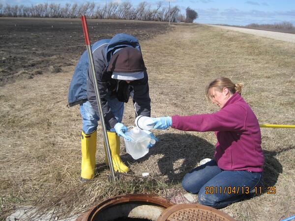
Sampling at Embden
Matt Lindsey (USGS) and Lori Clark (Cass County WCD) collecting samples at Embden 3. Embden 3 is a 60-degree V trapezoidal flume in a bured concreate culvert located on the other side of the north-south road east of the large data shelter.
Matt Lindsey (USGS) and Lori Clark (Cass County WCD) collecting samples at Embden 3. Embden 3 is a 60-degree V trapezoidal flume in a bured concreate culvert located on the other side of the north-south road east of the large data shelter.
Sheyenne River near Baldhill Dam, North Dakota
Sheyenne River at Baldhill Dam north of Valley City, North Dakota. USGS personnel were there at 5:00 p.m., to inspect the streamgage. Streamflow was approximately 6,500 cubic feet per second.
Sheyenne River at Baldhill Dam north of Valley City, North Dakota. USGS personnel were there at 5:00 p.m., to inspect the streamgage. Streamflow was approximately 6,500 cubic feet per second.

Baldhill Creek and Dazey 3
Discovery Farm Dazey waterway site 3 (seen between the trees) and Baldhill Creek. Located southeast of Dazey, North Dakota.
Discovery Farm Dazey waterway site 3 (seen between the trees) and Baldhill Creek. Located southeast of Dazey, North Dakota.

2011 Interstate 29 Flooding in North Dakota
Overland flooding on Interstate 29 in North Dakota caused by the Red River of the North (nearest town Oslo, Minnesota). This photograph was taken by the USGS National Flood Hazard Coordinator in one of the last small vehicles to drive on this stretch of the Interstate. About 15 minutes later, the North Dakota State Highway Patrol closed a stretch of the
Overland flooding on Interstate 29 in North Dakota caused by the Red River of the North (nearest town Oslo, Minnesota). This photograph was taken by the USGS National Flood Hazard Coordinator in one of the last small vehicles to drive on this stretch of the Interstate. About 15 minutes later, the North Dakota State Highway Patrol closed a stretch of the
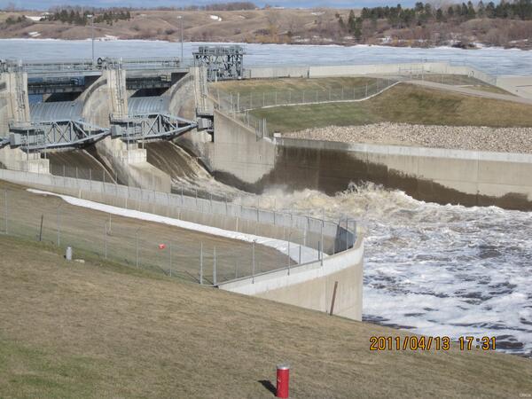
Maple River Dam below Sheldon, North Dakota
Maple River Dam north of Sheldon, southeast North Dakota. USGS personnel were there at 12:00 p.m., to inspect the streamgage. Streamflow was approximately 5,000 cubic feet per second.
Maple River Dam north of Sheldon, southeast North Dakota. USGS personnel were there at 12:00 p.m., to inspect the streamgage. Streamflow was approximately 5,000 cubic feet per second.

James River near New Rockford North Dakota
Rapid deployment gage on the James River at the BNSF bridge crossing, located 6 miles west of New Rockford. Equipment removing debris piled up on the bridge.
Rapid deployment gage on the James River at the BNSF bridge crossing, located 6 miles west of New Rockford. Equipment removing debris piled up on the bridge.

Removing Debris at gage 474300099153700
Rapid deployment gage on the James River at the BNSF bridge crossing, located 6 miles west of New Rockford. Equipment removing debris piled up on the bridge.
Rapid deployment gage on the James River at the BNSF bridge crossing, located 6 miles west of New Rockford. Equipment removing debris piled up on the bridge.

Deepwater Creek at Mouth near Raub, North Dakota
On April 11, 2011, USGS personnel were at the Deepwater Creek at Mouth near Raub, ND to measure the streamflow. Streamflow was approximately 2,610 cubic feet per second, stage approximately 13.82 feet.
On April 11, 2011, USGS personnel were at the Deepwater Creek at Mouth near Raub, ND to measure the streamflow. Streamflow was approximately 2,610 cubic feet per second, stage approximately 13.82 feet.

East Fork Shell Creek near Parshall, North Dakota
On April 10, 2011, USGS personnel were at the East Fork Shell Creek near Parchall, ND to measure the streamflow. Streamflow was approximately 911 cubic feet per second, stage approximately 6.68 feet.
On April 10, 2011, USGS personnel were at the East Fork Shell Creek near Parchall, ND to measure the streamflow. Streamflow was approximately 911 cubic feet per second, stage approximately 6.68 feet.

Media Film USGS Research in Fargo
USGS scientists Art Lilienthal and Dan Thomas bring a television news crew on a rainy tour of the flooded Red River, where they take water level and streamflow measurements during the Fargo flood.
USGS scientists Art Lilienthal and Dan Thomas bring a television news crew on a rainy tour of the flooded Red River, where they take water level and streamflow measurements during the Fargo flood.

Souris River near Sherwood, North Dakota
On April 10, 2011, USGS personnel were at the Souris River near Sherwood, ND to measure the streamflow. Streamflow was approximately 2,810 cubic feet per second, stage approximately 19.31 feet.
On April 10, 2011, USGS personnel were at the Souris River near Sherwood, ND to measure the streamflow. Streamflow was approximately 2,810 cubic feet per second, stage approximately 19.31 feet.