
Two U.S. Coast Guard members are being transported by crane from U.S. Coast Guard Cutter Healy onto a piece of multi-year ice. This was during a scientific expedition to map the Arctic seafloor. The expedition was a joint effort using two ships, Healy and the Canadian Coast Guard Ship Louis S. St. Laurent.
Images
Images
Filter Total Items: 9448

Lowered by Crane to Arctic Sea Ice
Two U.S. Coast Guard members are being transported by crane from U.S. Coast Guard Cutter Healy onto a piece of multi-year ice. This was during a scientific expedition to map the Arctic seafloor. The expedition was a joint effort using two ships, Healy and the Canadian Coast Guard Ship Louis S. St. Laurent.

XBT Used to Measure Speed of Sound
A U.S. Coast Guard member is preparing to launch an Expendable Bathythermograph (XBT) to help calculate the speed of sound in the ocean. The launcher sends a probe into the water to measure depth and temperature variation below the ship. There is a copper wire attached to both the launcher and the probe.
A U.S. Coast Guard member is preparing to launch an Expendable Bathythermograph (XBT) to help calculate the speed of sound in the ocean. The launcher sends a probe into the water to measure depth and temperature variation below the ship. There is a copper wire attached to both the launcher and the probe.

U.S. and Canadian Ships in Arctic Ocean
Helicopter view of Canadian Coast Guard Ship Louis S. St. Laurent (top) and U.S. Coast Guard Cutter Healy (bottom) on the Arctic Ocean. The ships are coming together because the crews are planning to meet and learn the operations of the other ship. This was during a scientific expedition to map the Arctic seafloor.
Helicopter view of Canadian Coast Guard Ship Louis S. St. Laurent (top) and U.S. Coast Guard Cutter Healy (bottom) on the Arctic Ocean. The ships are coming together because the crews are planning to meet and learn the operations of the other ship. This was during a scientific expedition to map the Arctic seafloor.

U.S. and Canadian Ships in Arctic Ocean
Helicopter view of U.S. Coast Guard Cutter Healy (left) and Canadian Coast Guard Ship Louis S. St. Laurent (right) on the Arctic Ocean. The ships are coming together because the crews are planning to meet and learn the operations of the other ship. This was during a scientific expedition to map the Arctic seafloor.
Helicopter view of U.S. Coast Guard Cutter Healy (left) and Canadian Coast Guard Ship Louis S. St. Laurent (right) on the Arctic Ocean. The ships are coming together because the crews are planning to meet and learn the operations of the other ship. This was during a scientific expedition to map the Arctic seafloor.

U.S. and Canadian Ships in Arctic Ocean
Helicopter view of Canadian Coast Guard Ship Louis S. St. Laurent (left) and U.S. Coast Guard Cutter Healy (right) on the Arctic Ocean. The ships are coming together because the crews are planning to meet and learn the operations of the other ship. This was during a scientific expedition to map the Arctic seafloor.
Helicopter view of Canadian Coast Guard Ship Louis S. St. Laurent (left) and U.S. Coast Guard Cutter Healy (right) on the Arctic Ocean. The ships are coming together because the crews are planning to meet and learn the operations of the other ship. This was during a scientific expedition to map the Arctic seafloor.

Bridge Operations on Healy
Visitors from Canadian Coast Guard Ship Louis S. St. Laurent learn about bridge operations on U.S. Coast Guard Cutter Healy. This was during a scientific expedition to map the Arctic seafloor.
Visitors from Canadian Coast Guard Ship Louis S. St. Laurent learn about bridge operations on U.S. Coast Guard Cutter Healy. This was during a scientific expedition to map the Arctic seafloor.

Flight Preparation
A group dressed in their flight suits and receiving final instructions for helicopter flight preparation before boarding U.S. Coast Guard Cutter Healy. This was during a scientific expedition to map the Arctic seafloor.
A group dressed in their flight suits and receiving final instructions for helicopter flight preparation before boarding U.S. Coast Guard Cutter Healy. This was during a scientific expedition to map the Arctic seafloor.

USGS and Japan Scientists Discuss Arctic Data
USGS oceanographer Ellyn Montgomery and Shigeto Nishino with the Japan Agency for Marine Earth Science & Technology (JAMSTEC) discuss measurements in a lab on Healy. Shigeto has spent three months on Canadian Coast Guard Ship Louis S. St.
USGS oceanographer Ellyn Montgomery and Shigeto Nishino with the Japan Agency for Marine Earth Science & Technology (JAMSTEC) discuss measurements in a lab on Healy. Shigeto has spent three months on Canadian Coast Guard Ship Louis S. St.

Low flow on the Knife River
Low flow with exposed rocks on the Knife River near Golden Valley, North Dakota.
Low flow with exposed rocks on the Knife River near Golden Valley, North Dakota.

Polar Bear Tracks Along Arctic Sea Ice
Polar bear tracks along a piece of Arctic sea ice.
Polar bear tracks along a piece of Arctic sea ice.
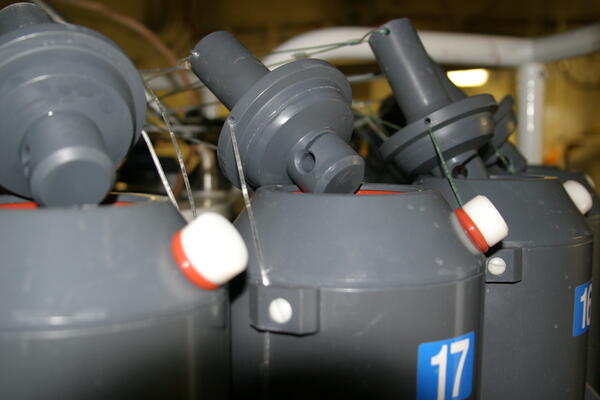
Conductivity Temperature Depth Profiler (CTD)
These are the lids both on top and below the water bottles on the Conductivity Temperature Depth Profiler (CTD). When the CTD is placed in the ocean and reaches a desired depth, an electronic signal is sent from the ship that closes the bottles and a water sample is collected.
These are the lids both on top and below the water bottles on the Conductivity Temperature Depth Profiler (CTD). When the CTD is placed in the ocean and reaches a desired depth, an electronic signal is sent from the ship that closes the bottles and a water sample is collected.

Canadian Helicopter Flying Over Arctic Ocean
A Canadian helicopter is flying over the Arctic Ocean during a trip from the Canadian Coast Guard ship Louis S. St. Laurent to U.S. Coast Guard Cutter Healy.
A Canadian helicopter is flying over the Arctic Ocean during a trip from the Canadian Coast Guard ship Louis S. St. Laurent to U.S. Coast Guard Cutter Healy.

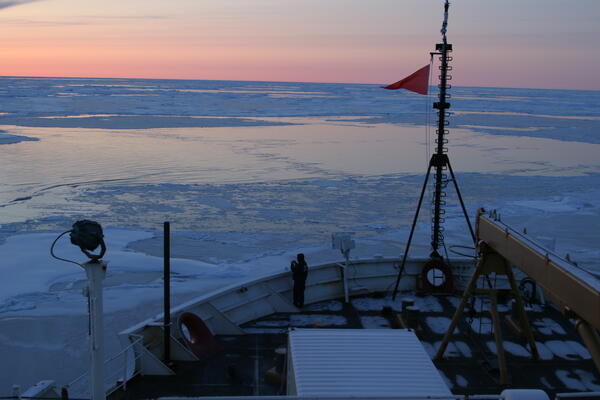
U.S. Coast Guard Cutter Healy
This is a view from the back of the U.S. Coast Guard Cutter Healy as it heads north in the Arctic Ocean.
This is a view from the back of the U.S. Coast Guard Cutter Healy as it heads north in the Arctic Ocean.

Polar Bears along Arctic Sea Ice
Polar bears along sea ice in the Arctic Ocean.
Polar bears along sea ice in the Arctic Ocean.

Conductivity Temperature Depth Profiler (CTD)
This is the top of the Conductivity Temperature Depth Profiler (CTD). When the instrument is lowered into the water and reaches a desired depth, an electronic signal is sent along these wires from the ship that closes the bottles and a water sample is collected.
This is the top of the Conductivity Temperature Depth Profiler (CTD). When the instrument is lowered into the water and reaches a desired depth, an electronic signal is sent along these wires from the ship that closes the bottles and a water sample is collected.

Arctic Sea Ice
Image of sea ice along the Arctic Ocean.
Image of sea ice along the Arctic Ocean.

Arctic Sea Ice
Image of sea ice along the Arctic Ocean.
Image of sea ice along the Arctic Ocean.

Arctic Sea Ice
Image of sea ice along the Arctic Ocean.
Image of sea ice along the Arctic Ocean.
Arctic Sea Ice
Image of Arctic sea ice.
Arctic Sea Ice
Image of Arctic sea ice.

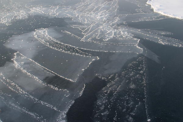
Arctic Sea Ice
This is an image of nilas, which is thin ice, in the Arctic Ocean. As nilas comes together like fingers, which is known as finger rafting, it creates thicker ice called young ice.
This is an image of nilas, which is thin ice, in the Arctic Ocean. As nilas comes together like fingers, which is known as finger rafting, it creates thicker ice called young ice.