
Native Americans of the Miwok tribe in the northern Sierra Nevada, California carved these basins into the granite bedrock to produce salt for trade. They filled the basins with water from a salt spring and let the water evaporate, leaving a salt residue in the basin. The basins are about a meter in diameter and span the area of a football field.
Images
Images
Filter Total Items: 9454

Native American Salt Basins in the Sierra Nevada
Native Americans of the Miwok tribe in the northern Sierra Nevada, California carved these basins into the granite bedrock to produce salt for trade. They filled the basins with water from a salt spring and let the water evaporate, leaving a salt residue in the basin. The basins are about a meter in diameter and span the area of a football field.

Brutus the North Pole Wolf
Brutus, a radio-tagged wolf being studied by USGS scientists, is a member of a pack of at least 12 adults and an unknown number of pups.
Brutus, a radio-tagged wolf being studied by USGS scientists, is a member of a pack of at least 12 adults and an unknown number of pups.

Brutus the North Pole Wolf
A mother wolf carries an errant pup back to their den.
A mother wolf carries an errant pup back to their den.

Massachusetts inner continental shelf
Massachusetts inner continental shelf bottom photograph showing seafloor life.
Massachusetts inner continental shelf bottom photograph showing seafloor life.
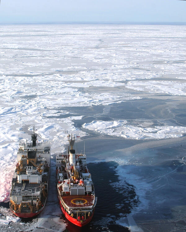
Cooperative Neighbors on Arctic Diplomacy
This photograph is of Canadian Coast Guard ship Louis S. St. Laurent alongside U.S. Coast Guard Cutter Healy in the Arctic Ocean. The U.S. and Canada are mapping the Arctic seafloor and gathering data to help define the outer limits of the continental shelf.
This photograph is of Canadian Coast Guard ship Louis S. St. Laurent alongside U.S. Coast Guard Cutter Healy in the Arctic Ocean. The U.S. and Canada are mapping the Arctic seafloor and gathering data to help define the outer limits of the continental shelf.

Bald Cypress Trunk and Cavity
Bald Cypress trees are iconic symbols of wetlands, but their distribution and range may be vulnerable to climate change impacts.
Bald Cypress trees are iconic symbols of wetlands, but their distribution and range may be vulnerable to climate change impacts.

Charcoal and Fireweed
Fireweed after fire in Alaska
Fireweed after fire in Alaska

Ice Queen
Block of Ice on Vitus Lake, from Bering Glacier, Alaska
Block of Ice on Vitus Lake, from Bering Glacier, Alaska

Ram in the Rockies
Foothills of the Front Range, Denver, CO
Foothills of the Front Range, Denver, CO

Lake Michigan Sand Waves
Calm Lake Michigan morning while sampling dead and dying fish for viral hemorrhagic septicemia virus (VHSV). This virus has recently emerged in the Great Lakes and caused severe epidemics in many fish species.
Calm Lake Michigan morning while sampling dead and dying fish for viral hemorrhagic septicemia virus (VHSV). This virus has recently emerged in the Great Lakes and caused severe epidemics in many fish species.

Lake Quinault Tribal Fish Netpens
Quinault tribal netpen facility in Lake Quinault, for rearing steelhead trout and chinook salmon
Quinault tribal netpen facility in Lake Quinault, for rearing steelhead trout and chinook salmon

Sunrise on the North Platte River
Sunrise on the North Platte River at Broadwater, Nebraska. Looking downstream from Hwy 92 bridge. January 2007.
Sunrise on the North Platte River at Broadwater, Nebraska. Looking downstream from Hwy 92 bridge. January 2007.

Establishing Fish Release Site on North Fork of Toutle River
Establishing Fish Release Site on North Fork of Toutle RiverEstablishing a release site for salmonids implanted with radio transmitters. Behavior and movement of salmon are monitored as they migrate through the Toutle River.
Establishing Fish Release Site on North Fork of Toutle River
Establishing Fish Release Site on North Fork of Toutle RiverEstablishing a release site for salmonids implanted with radio transmitters. Behavior and movement of salmon are monitored as they migrate through the Toutle River.

Retreating Glacier and Runoff from Glacial Melt
Retreating glacier south of Mt. Pendleton in Denali National Park, Alaska, with runoff from glacial melt seen in the foreground.
Retreating glacier south of Mt. Pendleton in Denali National Park, Alaska, with runoff from glacial melt seen in the foreground.

Mt. Hood
Picture taken while climbing Mt. Hood, Oregon, at sunset looking east.
Picture taken while climbing Mt. Hood, Oregon, at sunset looking east.
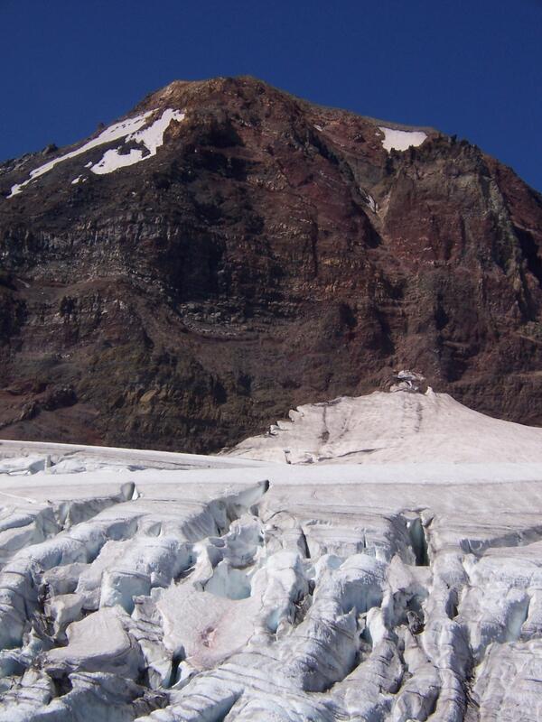
Middle Sister and Hayden Glacier
The North face of Middle Sister and Hayden Glacier, in Three Sisters Wilderness, Deschutes National Forest, Oregon. This Picture was taken while climbing Middle Sister. Middle Sister is also known as "Hope" and is an extinct stratovolcano.
The North face of Middle Sister and Hayden Glacier, in Three Sisters Wilderness, Deschutes National Forest, Oregon. This Picture was taken while climbing Middle Sister. Middle Sister is also known as "Hope" and is an extinct stratovolcano.

Surviving in the Arctic
This image is of two polar bears cuddled together on a piece of Arctic sea ice, surrounded by ocean water and thin layers of sea ice. This image allows for a deeper understanding of the endangered species and highlights the need for USGS research to help in their protection.
This image is of two polar bears cuddled together on a piece of Arctic sea ice, surrounded by ocean water and thin layers of sea ice. This image allows for a deeper understanding of the endangered species and highlights the need for USGS research to help in their protection.
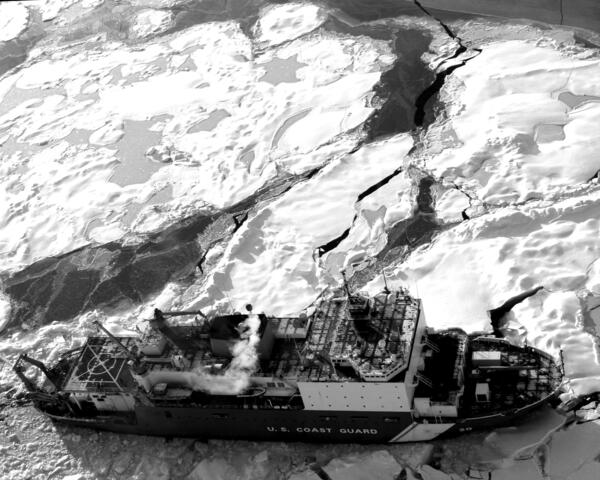
Healy Breaking Ice and Mapping Ground
This photograph is of U.S. Coast Guard Cutter Healy in the Arctic Ocean, where USGS scientists are helping map the Arctic seafloor and gather data to help define the outer limits of the continental shelf. The U.S. and Canada are working together in this mission, and the U.S. effort is through the U.S.
This photograph is of U.S. Coast Guard Cutter Healy in the Arctic Ocean, where USGS scientists are helping map the Arctic seafloor and gather data to help define the outer limits of the continental shelf. The U.S. and Canada are working together in this mission, and the U.S. effort is through the U.S.

Spiking a Quality Control Sample with MTBE
A scientist creates a quality control sample for a study of MTBE, (methyl tert-butyl ether) a fuel oxygenate used in gasoline.
A scientist creates a quality control sample for a study of MTBE, (methyl tert-butyl ether) a fuel oxygenate used in gasoline.

Camps Bay
Camps Bay, South Africa

Stream
Stream in Shenandoah National Park, Virginia.
Stream in Shenandoah National Park, Virginia.