
Nymph stage box elder bugs gather on the leaves of a hosta plant.
Images
Images
Filter Total Items: 9454

Boxelder Bugs Gather on the Leaves of Hosta 1
Nymph stage box elder bugs gather on the leaves of a hosta plant.

Boxelder Bugs Gather on the Leaves of Hosta 2
Adult and nymph stage box elder bugs gather on the leaves of a hosta plant growing at the base of a silver maple tree. Adults have fully formed, mainly black wings.
Adult and nymph stage box elder bugs gather on the leaves of a hosta plant growing at the base of a silver maple tree. Adults have fully formed, mainly black wings.

Boxelder Bugs Gather on the Leaves of Hosta 3
Adult, immature, and nymph stage box elder bugs gather on the leaves of a hosta plant growing at the base of a silver maple tree. Adults have fully formed, mainly black wings.
Adult, immature, and nymph stage box elder bugs gather on the leaves of a hosta plant growing at the base of a silver maple tree. Adults have fully formed, mainly black wings.

Crumbling blocks of permafrost along the Beaufort Coast
Crumbling blocks of permafrost along the Beaufort CoastCrumbling blocks of permafrost along the Beaufort Coast
Crumbling blocks of permafrost along the Beaufort Coast
Crumbling blocks of permafrost along the Beaufort CoastCrumbling blocks of permafrost along the Beaufort Coast

Early USGS streamgage on the San Saba river in Texas
Early USGS streamgage on the San Saba river in TexasAn early streamgage is used to measure water levels on San Saba River. USGS crews would visit this equipment to collect water level readings.
Early USGS streamgage on the San Saba river in Texas
Early USGS streamgage on the San Saba river in TexasAn early streamgage is used to measure water levels on San Saba River. USGS crews would visit this equipment to collect water level readings.

Alligator and Python Struggle
An American alligator and a Burmese python locked in a struggle to prevail in Everglades National Park. This python appears to be losing, but snakes in similar situations have apparently escaped unharmed, and in other situations pythons have eaten alligators.
An American alligator and a Burmese python locked in a struggle to prevail in Everglades National Park. This python appears to be losing, but snakes in similar situations have apparently escaped unharmed, and in other situations pythons have eaten alligators.

Routine Maintenance on a Ground-Water Monitoring Well.
Routine Maintenance on a Ground-Water Monitoring Well.Routine maintenance on a ground-water monitoring well,
Perry Park, Brunswick, Glynn County, Georgia. At one time this well was used by the City of Brunswick for drinking water. Saltwater intrusion forced the city to abandon the well, so the USGS started monitoring it for water levels and specific conductance.

Earthwork in Parkfield
The earthwork in context of the small town of Parkfield, CA.
The earthwork in context of the small town of Parkfield, CA.

Aerial Photo of Shake Table
Photo taken from a kite-lofted camera, showing the shake table and control bunker.
Photo taken from a kite-lofted camera, showing the shake table and control bunker.

View of the San Andreas Fault
View looking southeast along the surface trace of the San Andreas fault in the Carrizo Plain, north of Wallace Creek. Elkhorn Rd. meets the fault near the top of the photo.
View looking southeast along the surface trace of the San Andreas fault in the Carrizo Plain, north of Wallace Creek. Elkhorn Rd. meets the fault near the top of the photo.

Bois de Sioux River
The Bois de Sioux river channel near White Rock, SD.
The Bois de Sioux river channel near White Rock, SD.

Road Repair in Indian Country
Workers repairing a road.

Stillwater Mine
Rocks from the Stillwater Mine are collected, ground, and blended with other rocks and materials to make the lunar regolith simulant.
__________
Rocks from the Stillwater Mine are collected, ground, and blended with other rocks and materials to make the lunar regolith simulant.
__________

Molten Rock Streaming into Water
The molten rock streams through an opening in the melter into a large container of water below, where it instantly cools into glass.
__________
The molten rock streams through an opening in the melter into a large container of water below, where it instantly cools into glass.
__________

Stocking Walleye Fish
An FWS employee stocks walleye in a lined pond at Garrison Dam National Fish Hatchery, the Service's largest walleye production hatchery. Related to the R6PC Replace 9 Clay Pond Liners Garrison Dam NFH project.
An FWS employee stocks walleye in a lined pond at Garrison Dam National Fish Hatchery, the Service's largest walleye production hatchery. Related to the R6PC Replace 9 Clay Pond Liners Garrison Dam NFH project.

Proposed Construction Site at Audubon NWR
This is a view of the plot of land at Audubon National Wildlife Refuge selected for the Headquarters and Visitor Center that will be built with Recovery Act funding. Related to the R6BB Construct Headquarters Visitor Building Audubon NWR project.
This is a view of the plot of land at Audubon National Wildlife Refuge selected for the Headquarters and Visitor Center that will be built with Recovery Act funding. Related to the R6BB Construct Headquarters Visitor Building Audubon NWR project.
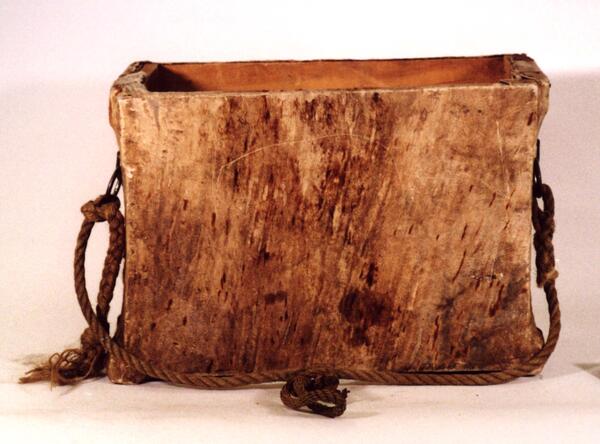
Rawhide Pannier
This rawhide pannier was made for Dr. J. D. Love in 1945. It consists of rawhide stretched over wooden frames. For transportation, this type of pannier was made to hang on animals with wooden pack saddles.
Object ID: USGS-000027
This rawhide pannier was made for Dr. J. D. Love in 1945. It consists of rawhide stretched over wooden frames. For transportation, this type of pannier was made to hang on animals with wooden pack saddles.
Object ID: USGS-000027
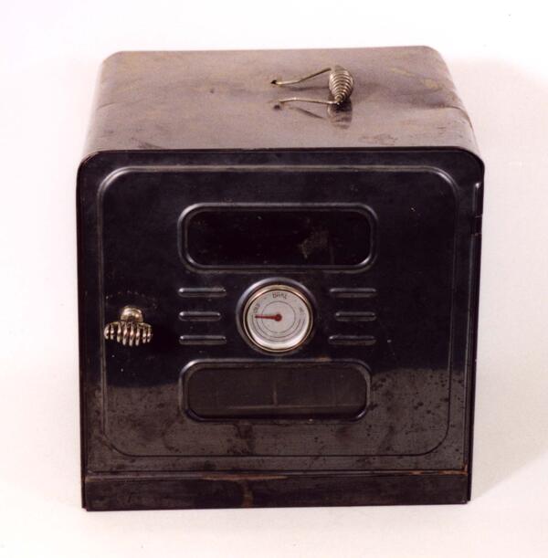
Warming Oven
This oven was made for cooking on top of a stove. There is no heating source, but the bottom is open and the oven sits on a heated stove for warmth. There are racks inside and a small temperature gauge on the oven door. The oven was used by scientists at their campsites.
Object ID: USGS-000111
This oven was made for cooking on top of a stove. There is no heating source, but the bottom is open and the oven sits on a heated stove for warmth. There are racks inside and a small temperature gauge on the oven door. The oven was used by scientists at their campsites.
Object ID: USGS-000111
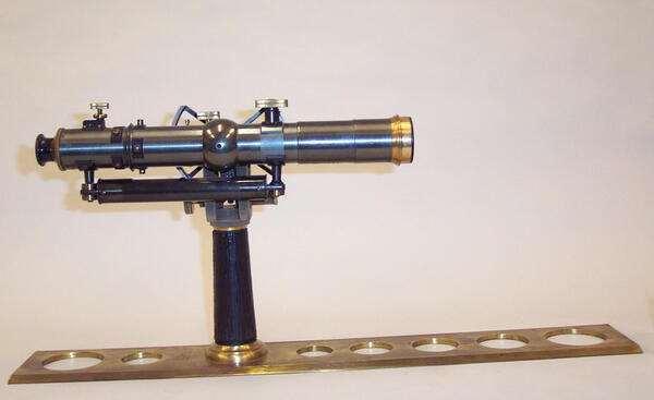
Explorer's Alidade
Manufactured by Keuffel & Esser, New York & New Jersey. In this type of alidade, as opposed to the high standard, the telescope mounted close to the straightedge, producing a more compact instrument. A right-angle prism is attached to the eyepiece and permits viewing by looking down.
Manufactured by Keuffel & Esser, New York & New Jersey. In this type of alidade, as opposed to the high standard, the telescope mounted close to the straightedge, producing a more compact instrument. A right-angle prism is attached to the eyepiece and permits viewing by looking down.
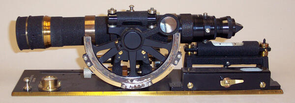
Telescopic Alidade
A high standard alidade; this type of alidade permits direct viewing through the telescope. The level is mounted below the inverting telescope and the base (blade) is solid brass with circular voids. Manufactured by Keuffel & Esser, New York & New Jersey.
Object ID: USGS-000165
A high standard alidade; this type of alidade permits direct viewing through the telescope. The level is mounted below the inverting telescope and the base (blade) is solid brass with circular voids. Manufactured by Keuffel & Esser, New York & New Jersey.
Object ID: USGS-000165
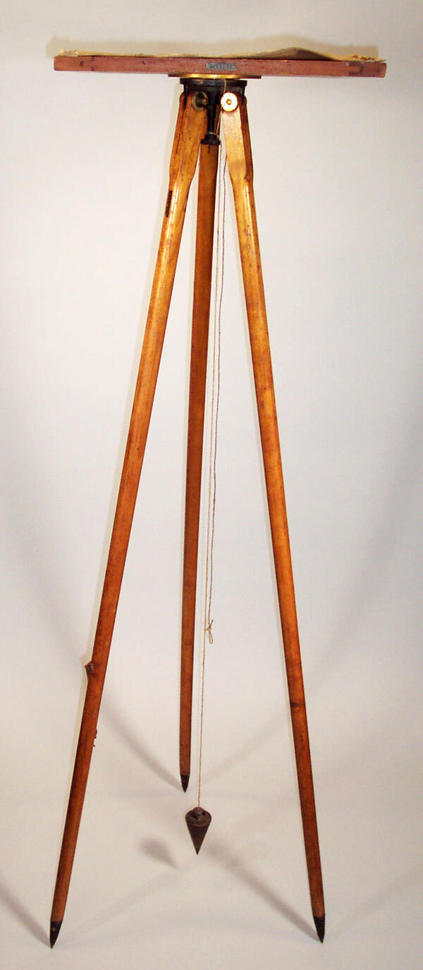
Plane Table with Tripod
Plane tables are also known as drawing boards. The round leg tripod is made from hardwood, with a bronze head, steel tips and plum bob.
Object ID: USGS-000210
Plane tables are also known as drawing boards. The round leg tripod is made from hardwood, with a bronze head, steel tips and plum bob.
Object ID: USGS-000210