
Sinabung volcano in Indonesia on August 14, 2016. Photograph credit: Christoph Kern, USGS
Images
Images
Filter Total Items: 9449

Sinabung Volcano
Sinabung volcano in Indonesia on August 14, 2016. Photograph credit: Christoph Kern, USGS

Sinabung Volcano
Monitoring equipment being installed at Sinabung volcano in Indonesia on August 14, 2016. Photograph credit: Christoph Kern, USGS
Monitoring equipment being installed at Sinabung volcano in Indonesia on August 14, 2016. Photograph credit: Christoph Kern, USGS

Flooded House in Denham Springs
A flooded house near the confluence of the Comite and Amite Rivers near Denham Springs, LA.
A flooded house near the confluence of the Comite and Amite Rivers near Denham Springs, LA.

Flooded Neighborhood in Denham Springs
A flooded neighborhood near the confluence of the Comite and Amite Rivers near Denham Springs, LA.
A flooded neighborhood near the confluence of the Comite and Amite Rivers near Denham Springs, LA.

Flooded Street in Denham Springs
Backwater flooding across Florida Blvd near the Amite River Bridge in Denham Springs, LA.
Backwater flooding across Florida Blvd near the Amite River Bridge in Denham Springs, LA.

USGS scientists prepare water-quality instruments
USGS scientists prepare water-quality instruments before going out on the Great Salt Lake. USGS scientists are conducting a study to gain a better understanding of nutrient levels, which could help determine how to best manage algal bloom outbreaks.
USGS scientists prepare water-quality instruments before going out on the Great Salt Lake. USGS scientists are conducting a study to gain a better understanding of nutrient levels, which could help determine how to best manage algal bloom outbreaks.

USGS scientists conducting a study on the Great Salt Lake
USGS scientists conducting a study on the Great Salt LakeUSGS scientists conducting a study on the Great Salt Lake to gain a better understanding of nutrient levels, which could help determine how to best manage algal bloom outbreaks.
USGS scientists conducting a study on the Great Salt Lake
USGS scientists conducting a study on the Great Salt LakeUSGS scientists conducting a study on the Great Salt Lake to gain a better understanding of nutrient levels, which could help determine how to best manage algal bloom outbreaks.

USGS scientists conducting a study on the Great Salt Lake
USGS scientists conducting a study on the Great Salt LakeUSGS scientists conducting a study on the Great Salt Lake to gain a better understanding of nutrient levels, which could help determine how to best manage algal bloom outbreaks.
USGS scientists conducting a study on the Great Salt Lake
USGS scientists conducting a study on the Great Salt LakeUSGS scientists conducting a study on the Great Salt Lake to gain a better understanding of nutrient levels, which could help determine how to best manage algal bloom outbreaks.

USGS water-quality instruments to measure nutrient levels
USGS water-quality instruments to measure nutrient levelsUSGS scientists use multiple high-frequency water quality instruments contained in a cage to measure nutrients and algal changes in surface water. Scientists are conducting an experimental study on two Utah water bodies to gain a better understanding of nutrient levels, which could help determine how to best manage algal bloom outbreaks.

Scientists measure nutrient levels
USGS scientists Christopher L. Shope, Bryan Downing, Katy O'Donnell and Mike Freeman measure nutrient levels in Goggin Drain, Utah. USGS scientists are conducting an experimental study on two Utah water bodies to gain a better understanding of nutrient levels, which could help determine how to best manage algal bloom outbreaks.
USGS scientists Christopher L. Shope, Bryan Downing, Katy O'Donnell and Mike Freeman measure nutrient levels in Goggin Drain, Utah. USGS scientists are conducting an experimental study on two Utah water bodies to gain a better understanding of nutrient levels, which could help determine how to best manage algal bloom outbreaks.

USGS scientist measures nutrient levels
USGS scientist Mike Freeman measures nutrient levels in Goggin Drain, Utah. USGS scientists are conducting an experimental study on two Utah water bodies to gain a better understanding of nutrient levels, which could help determine how to best manage algal bloom outbreaks.
USGS scientist Mike Freeman measures nutrient levels in Goggin Drain, Utah. USGS scientists are conducting an experimental study on two Utah water bodies to gain a better understanding of nutrient levels, which could help determine how to best manage algal bloom outbreaks.

USGS scientists measure nutrient levels
USGS scientists Christopher L. Shope, Bryan Downing, Katy O'Donnell and Mike Freeman measure nutrient levels in Goggin Drain, Utah. USGS scientists are conducting an experimental study on two Utah water bodies to gain a better understanding of nutrient levels, which could help determine how to best manage algal bloom outbreaks.
USGS scientists Christopher L. Shope, Bryan Downing, Katy O'Donnell and Mike Freeman measure nutrient levels in Goggin Drain, Utah. USGS scientists are conducting an experimental study on two Utah water bodies to gain a better understanding of nutrient levels, which could help determine how to best manage algal bloom outbreaks.

Utah Nutrient Study
USGS scientists Bryan Downing, Mike Freeman and Katy O'Donnell measure nutrient levels in Goggin Drain, Utah. USGS scientists are conducting an experimental study on two Utah water bodies to gain a better understanding of nutrient levels, which could help determine how to best manage algal bloom outbreaks.
USGS scientists Bryan Downing, Mike Freeman and Katy O'Donnell measure nutrient levels in Goggin Drain, Utah. USGS scientists are conducting an experimental study on two Utah water bodies to gain a better understanding of nutrient levels, which could help determine how to best manage algal bloom outbreaks.

USGS Biologist prepares to release a reproductive female sturgeon.
USGS Biologist prepares to release a reproductive female sturgeon.USGS Biologist Sabrina Davenport prepares to release a reproductive female pallid sturgeon.
USGS Biologist prepares to release a reproductive female sturgeon.
USGS Biologist prepares to release a reproductive female sturgeon.USGS Biologist Sabrina Davenport prepares to release a reproductive female pallid sturgeon.

Lake sturgeon at the USGS Columbia Environmental Research Center
Lake sturgeon at the USGS Columbia Environmental Research CenterUSGS Biologist prepares to artificially spawn a female lake sturgeon in the laboratory at the Columbia Environmental Research Center.
Lake sturgeon at the USGS Columbia Environmental Research Center
Lake sturgeon at the USGS Columbia Environmental Research CenterUSGS Biologist prepares to artificially spawn a female lake sturgeon in the laboratory at the Columbia Environmental Research Center.
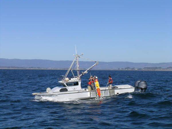
Tethys 1
Monterey Bay Aquarium Research Institute researchers launch the long-range autonomous underwater vehicle Tethys from the research vessel Paragon in Monterey Bay. This AUV travels through the water without direct control from shore, collecting information about the physical, chemical, and biological characteristics of the surrounding seawater.
Monterey Bay Aquarium Research Institute researchers launch the long-range autonomous underwater vehicle Tethys from the research vessel Paragon in Monterey Bay. This AUV travels through the water without direct control from shore, collecting information about the physical, chemical, and biological characteristics of the surrounding seawater.
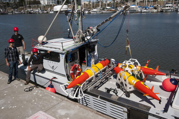
Tethys 3
MBARI researchers with three long-range autonomous underwater vehicles on the Research Vessel Paragon.
MBARI researchers with three long-range autonomous underwater vehicles on the Research Vessel Paragon.
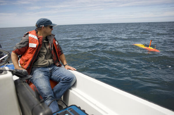
Tethys 2
Tethys, MBARI's long-range AUV, at sea in Monterey Bay.
Tethys, MBARI's long-range AUV, at sea in Monterey Bay.

USGS scientist and girls next to a lake, seiving sediment
USGS scientist and girls next to a lake, seiving sedimentLed by USGS scientist Cynthia Gardner, GeoGirls collect and sort sediments from the shore of Coldwater Lake, near Mount St. Helens, examining evidence of the May 18, 1980 landslide that dammed Coldwater Creek to create the lake.

Uncrewed underwater vehicle
The information collected by advanced technologies, like this uncrewed underwater vehicle, can be used by managers to sustain and support the Great Lakes’ valuable natural resources.
The information collected by advanced technologies, like this uncrewed underwater vehicle, can be used by managers to sustain and support the Great Lakes’ valuable natural resources.

Sampling for Bsal
Scientists sample a rough-skinned newt for the fungal pathogen Batrachochytrium salamandrivorans, or Bsal, at a pond near Portland, Oregon. Bsal is decimating wild salamander populations in Europe and could emerge in the U.S. thro
Scientists sample a rough-skinned newt for the fungal pathogen Batrachochytrium salamandrivorans, or Bsal, at a pond near Portland, Oregon. Bsal is decimating wild salamander populations in Europe and could emerge in the U.S. thro