
Scientists sample a rough-skinned newt for the fungal pathogen Batrachochytrium salamandrivorans, or Bsal, at a pond near Portland, Oregon. Bsal is decimating wild salamander populations in Europe and could emerge in the U.S. thro
Images
Images
Filter Total Items: 9449

Sampling for Bsal
Scientists sample a rough-skinned newt for the fungal pathogen Batrachochytrium salamandrivorans, or Bsal, at a pond near Portland, Oregon. Bsal is decimating wild salamander populations in Europe and could emerge in the U.S. thro

Water-quality sensors kept clean for harmful algal bloom monitoring
Water-quality sensors kept clean for harmful algal bloom monitoringSensors are cleaned with an automatic wiper brush on the continuous water-quality monitors.
Water-quality sensors kept clean for harmful algal bloom monitoring
Water-quality sensors kept clean for harmful algal bloom monitoringSensors are cleaned with an automatic wiper brush on the continuous water-quality monitors.
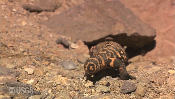
Gila Shake
Can you do the Charleston? This animated GIF takes frames from a USGS video on the gila monster and reverses them to make this Southwestern lizard shake his tail...or perhaps dancing the Charleston.
Can you do the Charleston? This animated GIF takes frames from a USGS video on the gila monster and reverses them to make this Southwestern lizard shake his tail...or perhaps dancing the Charleston.

USGS scientist collects noble gas sample from spring site
USGS scientist collects noble gas sample from spring siteUSGS scientist collects noble gas sample from spring site near Roaring Judy, Colorado. Groundwater discharge that flows into the Upper Colorado River Basin varies in response to drought, which is likely due to aquifer systems that contain relatively young groundwater, according to a new U

Coarse Diabase
Diabase is a mafic (meaning high in magnesium and iron), igneous rock that usually forms below the Earth’s surface. This particular one has large amounts of augite and labradorite minerals, and comes from the Lucke Quarry, which is southeast of Leesburg, VA.
Diabase is a mafic (meaning high in magnesium and iron), igneous rock that usually forms below the Earth’s surface. This particular one has large amounts of augite and labradorite minerals, and comes from the Lucke Quarry, which is southeast of Leesburg, VA.

USGS National Center North Entrance and Volcanic Crystal Columns
USGS National Center North Entrance and Volcanic Crystal ColumnsGranite is an igneous rock that we’ve used for building materials for thousands of years. It’s name comes from the Latin word “granum,” meaning “grain,” which refers to the grains of quartz and feldspar that define granite. This one is from the Barre formation in Vermont.

Leesburg Conglomerate
Conglomerates are sedimentary rocks that are made up of various fragments of rock interspersed with finer grained material. This particular conglomerate was deposited as a fan on the northwest side of the Culpeper Basin.
Conglomerates are sedimentary rocks that are made up of various fragments of rock interspersed with finer grained material. This particular conglomerate was deposited as a fan on the northwest side of the Culpeper Basin.

Cockeysville Marble
Marble is a famous metamorphic rock known for its use in sculpture and architecture. This particular marble came from the Campbell Quarry in Texas, Maryland.
Marble is a famous metamorphic rock known for its use in sculpture and architecture. This particular marble came from the Campbell Quarry in Texas, Maryland.

Diopside Crystals
Diopside crystals are made up of Magnesium, Calcium, Silicon and Oxygen, and are usually found in metamorphic rocks. These crystals have developed in some Cockeysville Marble from Texas, Maryland.
Diopside crystals are made up of Magnesium, Calcium, Silicon and Oxygen, and are usually found in metamorphic rocks. These crystals have developed in some Cockeysville Marble from Texas, Maryland.

USGS National Center
The USGS National Center

Cordierite Hornfels
Hornfels rocks are metamorphic rocks. They usually start out as sedimentary rocks like sandstone or shale, but then volcanic material pushes up from below and bakes the sedimentary rock into a metamorphic one. Hornfels are known for being exceptionally tough and durable. This one is from Chantilly, VA.
Hornfels rocks are metamorphic rocks. They usually start out as sedimentary rocks like sandstone or shale, but then volcanic material pushes up from below and bakes the sedimentary rock into a metamorphic one. Hornfels are known for being exceptionally tough and durable. This one is from Chantilly, VA.

Cannel Coal
Cannel coal is a type of bituminous coal, which is the second-highest rank of coal (just behind anthracite). This particular sample has a high carbon content with high pollen and spore content as well. Unlike most bituminous coal, Cannel coal can be carved into ornaments. This sample came from the Eastern Interior Coalfield in Kentucky.
Cannel coal is a type of bituminous coal, which is the second-highest rank of coal (just behind anthracite). This particular sample has a high carbon content with high pollen and spore content as well. Unlike most bituminous coal, Cannel coal can be carved into ornaments. This sample came from the Eastern Interior Coalfield in Kentucky.

Spring sampling in Wyoming
Spring sampling location along Little Sandy River in southern Wyoming. Groundwater discharge that flows into the Upper Colorado River Basin varies in response to drought, which is likely due to aquifer systems that contain relatively young groundwater, according to a new U.S.
Spring sampling location along Little Sandy River in southern Wyoming. Groundwater discharge that flows into the Upper Colorado River Basin varies in response to drought, which is likely due to aquifer systems that contain relatively young groundwater, according to a new U.S.

Water quality and sampling at spring site
Water quality and sampling equipment deployed at spring site near Roaring Judy, Colorado. Groundwater discharge that flows into the Upper Colorado River Basin varies in response to drought, which is likely due to aquifer systems that contain relatively young groundwater, according to a new U.S
Water quality and sampling equipment deployed at spring site near Roaring Judy, Colorado. Groundwater discharge that flows into the Upper Colorado River Basin varies in response to drought, which is likely due to aquifer systems that contain relatively young groundwater, according to a new U.S

USGS National Center Benchmark
A USGS benchmark at the USGS National Center.
A USGS benchmark at the USGS National Center.

Barre Granite
Granite is an igneous rock that we’ve used for building materials for thousands of years. It’s name comes from the Latin word “granum,” meaning “grain,” which refers to the grains of quartz and feldspar that define granite. This one is from the Barre formation in Vermont.
Granite is an igneous rock that we’ve used for building materials for thousands of years. It’s name comes from the Latin word “granum,” meaning “grain,” which refers to the grains of quartz and feldspar that define granite. This one is from the Barre formation in Vermont.

Landsat Pine Beetle Pair
Landsat image taken in 1992 shows the Uinta Mountains east of Salt Lake City. The shades of dark green indicate healthy, undisturbed forest. Landsat image of the same area in 2010 captures the dramatic assault of mountain pine beetles. The dark red stains reveal widespread pine beetle destruction.
Landsat image taken in 1992 shows the Uinta Mountains east of Salt Lake City. The shades of dark green indicate healthy, undisturbed forest. Landsat image of the same area in 2010 captures the dramatic assault of mountain pine beetles. The dark red stains reveal widespread pine beetle destruction.

Pallid sturgeon free embryo at approximately 2 days post-hatch
Pallid sturgeon free embryo at approximately 2 days post-hatchPallid sturgeon free embryo at approximately 2 days post-hatch, approximately 11-12 mm (about 0.45 of an inch) in length.
Pallid sturgeon free embryo at approximately 2 days post-hatch
Pallid sturgeon free embryo at approximately 2 days post-hatchPallid sturgeon free embryo at approximately 2 days post-hatch, approximately 11-12 mm (about 0.45 of an inch) in length.

Pallid sturgeon free embryo at approximately 5 days post-hatch
Pallid sturgeon free embryo at approximately 5 days post-hatchFigure 3. Pallid sturgeon free embryo at approximately 5 days post-hatch, approximately 14-15 mm (about 0.57 of an inch) in length.
Pallid sturgeon free embryo at approximately 5 days post-hatch
Pallid sturgeon free embryo at approximately 5 days post-hatchFigure 3. Pallid sturgeon free embryo at approximately 5 days post-hatch, approximately 14-15 mm (about 0.57 of an inch) in length.

Pallid sturgeon free embryo at approximately 10 days post-hatch
Pallid sturgeon free embryo at approximately 10 days post-hatchPallid sturgeon free embryo at approximately 10 days post-hatch, approximately 19-20 mm (about 0.77 of an inch) in length.
Pallid sturgeon free embryo at approximately 10 days post-hatch
Pallid sturgeon free embryo at approximately 10 days post-hatchPallid sturgeon free embryo at approximately 10 days post-hatch, approximately 19-20 mm (about 0.77 of an inch) in length.

Newly hatched pallid sturgeon free embryos.
Pallid sturgeon free embryos on the day of hatch, approximately 8-9 mm (about 0.33 of an inch) in length.
Pallid sturgeon free embryos on the day of hatch, approximately 8-9 mm (about 0.33 of an inch) in length.